Difference between revisions of "User:Tonique"
From Geohashing
imported>Thomcat m |
m (fix, sorry) |
||
| (One intermediate revision by the same user not shown) | |||
| Line 9: | Line 9: | ||
==Geohashings== | ==Geohashings== | ||
| − | *[[2008-06-28 62 25|2008-06-28]]: The spot was in | + | *[[2008-06-28 62 25|2008-06-28]]: The spot was in {{egl|2008-06-28|62|25|text=lake Summanen}} – [http://kansalaisen.karttapaikka.fi/koordinaatit/koordinaatit.html?y=62.6581109587854854&x=25.3656341768225246&srsName=LATLON%3Aetrs&show=N%C3%A4yt%C3%A4+kartalla&lang=FI&scale=16000&tool=siirra&styles=normal&lang=FI Finnish map service] between the island of Summassaari and mainland. The centre of Saarijärvi is about 4 km away. No boat, so I went to the nearby, narrow cape, Haikanniemi (you can browse the Finnish map). Some people seemed to be fishing near the actual spot. This first try was a failed one. |
<gallery caption="Pictures" widths="150px" perrow="3"> | <gallery caption="Pictures" widths="150px" perrow="3"> | ||
Latest revision as of 19:28, 18 January 2022
tonique
Jyväskylä, Finland (62, 25)
Connections to Hetta, Finland (68, 23) and Peltovuoma, Finland (68,24)
I haven't got a GPS navigator/thingy, so exact proofs must wait.
Geohashings
- 2008-06-28: The spot was in lake Summanen – Finnish map service between the island of Summassaari and mainland. The centre of Saarijärvi is about 4 km away. No boat, so I went to the nearby, narrow cape, Haikanniemi (you can browse the Finnish map). Some people seemed to be fishing near the actual spot. This first try was a failed one.
- Pictures
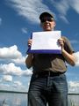
tonique at the uttermost point of Haikanniemi
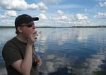
Made some soap bubbles!
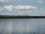
This is the approximate direction to the actual spot from the place marked on the map.


