Difference between revisions of "Helgoland, Germany"
From Geohashing
imported>ReletBot m (Updated graticule template with information from All Graticules, using standard format.) |
m (per Renaming Proposal) |
||
| (8 intermediate revisions by 4 users not shown) | |||
| Line 7: | Line 7: | ||
| w = [[North Sea 54, 6|North Sea]] | | w = [[North Sea 54, 6|North Sea]] | ||
| name = [[Helgoland, Germany|Helgoland]] | | name = [[Helgoland, Germany|Helgoland]] | ||
| − | | e = [[ | + | | e = [[Westerland, Germany|Westerland]] |
| sw = [[Groningen, Netherlands]] | | sw = [[Groningen, Netherlands]] | ||
| s = [[Emden, Germany|Emden]] | | s = [[Emden, Germany|Emden]] | ||
| Line 13: | Line 13: | ||
}} | }} | ||
| − | == About == | + | ==About== |
| − | + | The Helgoland [[graticule]] is at {{Today's location|lat=54|lon=7|text=latitude 54, longitude 7}}. With the only landmasses being two islands totaling about 4.2 km², the odds of a hash being in the sea are overwhelming. The graticule's area is distributed as follows: | |
| − | The Helgoland [[graticule]] is at | ||
<pre> | <pre> | ||
99.98% Water | 99.98% Water | ||
| Line 21: | Line 20: | ||
</pre> | </pre> | ||
Statistically, a geohash in this graticule falls on land rougly once in 14 years, meaning one land geohash from the inception of the game through 2020. | Statistically, a geohash in this graticule falls on land rougly once in 14 years, meaning one land geohash from the inception of the game through 2020. | ||
| + | ===Map and stats=== | ||
| + | [[File:Region 54,7 Admin 4.svg|200px]] | ||
| + | {| class="wikitable" | ||
| + | !Name!!code!!area type!!Geohash<br />probability | ||
| + | |- | ||
| + | |<span style="color:rgba(237,244,168,255)">■</span> Schleswig-Holstein||SH||land||0.024% | ||
| + | |- | ||
| + | |<span style="color:rgba(217,239,211,255)">■</span> Schleswig-Holstein||SH||incl. waters||18.1% | ||
| + | |- | ||
| + | |<span style="color:rgba(226,244,223,255)">■</span> Niedersachsen||NI||waters||1.6% | ||
| + | |} | ||
| + | |||
| + | ==Expeditions== | ||
| + | * [[2018-11-29 54 7]] - [[User:Fippe|Fippe]] was the first to document a geohashing expedition on Helgoland. | ||
==Previous hash locations== | ==Previous hash locations== | ||
| − | + | * On {{egl|2008-05-21|54|7|text=2008-05-21}} (the first day of geohashing), the hash was about 1.050 meters off the western shore. | |
| − | * On | + | * On {{egl|2008-09-18|54|7|text=2008-09-18}} the geohash was about 50 meters off the eastern shore of Helgoland, between the two islands. |
| − | * On | + | * Hit! On {{egl|2013-01-08|54|7|text=2013-01-08}} the geohash was located on the island Helgoland-Düne (Heligoland dune). |
| − | * Hit! On | ||
| − | |||
[[Category:Germany]] | [[Category:Germany]] | ||
[[Category:Inactive graticules]] | [[Category:Inactive graticules]] | ||
| + | [[Category:Unlocked graticules]] | ||
Latest revision as of 01:56, 20 March 2024
| North Sea | North Sea | Esbjerg, Denmark |
| North Sea | Helgoland | Westerland |
| Groningen, Netherlands | Emden | Bremen |
|
Today's location: geohashing.info google osm bing/os kml crox | ||
About
The Helgoland graticule is at latitude 54, longitude 7. With the only landmasses being two islands totaling about 4.2 km², the odds of a hash being in the sea are overwhelming. The graticule's area is distributed as follows:
99.98%	Water
 0.02%  Land
Statistically, a geohash in this graticule falls on land rougly once in 14 years, meaning one land geohash from the inception of the game through 2020.
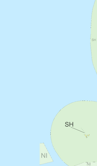
Map and stats
| Name | code | area type | Geohash probability |
|---|---|---|---|
| ■ Schleswig-Holstein | SH | land | 0.024% |
| ■ Schleswig-Holstein | SH | incl. waters | 18.1% |
| ■ Niedersachsen | NI | waters | 1.6% |
Expeditions
- 2018-11-29 54 7 - Fippe was the first to document a geohashing expedition on Helgoland.
Previous hash locations
- On 2008-05-21 (the first day of geohashing), the hash was about 1.050 meters off the western shore.
- On 2008-09-18 the geohash was about 50 meters off the eastern shore of Helgoland, between the two islands.
- Hit! On 2013-01-08 the geohash was located on the island Helgoland-Düne (Heligoland dune).
