Difference between revisions of "2021-05-19 48 11"
Clearlucid9 (talk | contribs) (→Photos) |
Clearlucid9 (talk | contribs) |
||
| (3 intermediate revisions by the same user not shown) | |||
| Line 1: | Line 1: | ||
{{meetup graticule | {{meetup graticule | ||
| − | | date=2021-05- | + | | date=2021-05-19 |
| lat=48 | | lat=48 | ||
| lon=11 | | lon=11 | ||
| Line 19: | Line 19: | ||
<gallery> | <gallery> | ||
File:2021-05-19 17.35.37.jpg | logproof | File:2021-05-19 17.35.37.jpg | logproof | ||
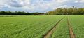
| − | File:2021-05-19 17.36.01.jpg | + | File:2021-05-19 17.36.01.jpg | standing at the hash coordinates |
| − | File:2021-05-19 17.36.08.jpg | + | File:2021-05-19 17.36.08.jpg | looking towards Grasbrunn |
| − | File:2021-05-19 17.36.13.jpg | + | File:2021-05-19 17.36.13.jpg | looking towards the Autobahn |
| − | File:2021-05-19 17.36.19.jpg | + | File:2021-05-19 17.36.19.jpg | way back |
</gallery> | </gallery> | ||
| − | + | __NOTOC__ | |
| + | [[Category:Expeditions]] | ||
| + | [[Category:Coordinates reached]] | ||
| + | [[Category:Expeditions with photos]] | ||
{{location|DE|BY|M}} | {{location|DE|BY|M}} | ||
| + | [[Category:Expeditions by Clearlucid9]] | ||
Latest revision as of 17:23, 19 May 2021
| Wed 19 May 2021 in Munich: 48.0870125, 11.7448975 geohashing.info google osm bing/os kml crox |
Location
in a field between Grasbrunn and the A99 motorway
Participants
Expedition
It's been raining on and off today, but at the time I finished in the homeoffice there was a glimpse of sunshine. Hence I opted to go to the hash get some fresh air and relax a little. It took me about 15 minutes to drive to the parking of the local sports center and from there I went walking. The hash was in the middle of a field, but as far as I could tell it wasn't fresh crops, but it rather looked like standard grass, but all freshly seeded. Therefore I took the long way around the field to a point on the other side that was just 30m off from the hash. I carefully walked in a straight line to the hash coordinates. After taking my pictures I took the direct way back to the car, getting my boots real dirty...
Photos
logproof
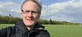
standing at the hash coordinates
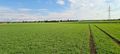
looking towards Grasbrunn
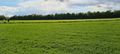
looking towards the Autobahn
way back


