Difference between revisions of "2021-06-14 53 6"
(Expedition page creation) |
(Report not getting the Last Man Standing achievement.) |
||
| (3 intermediate revisions by 2 users not shown) | |||
| Line 1: | Line 1: | ||
| − | + | [[Image:{{{image|2021-06-14 53 6 trees.jpg}}}|thumb|left]] | |
| − | + | {{meetup graticule | |
| − | [[Image:{{{image| | + | | lat=53 |
| − | + | | lon=6 | |
| − | + | | date=2021-06-14 | |
| − | + | }} | |
| − | |||
| − | |||
| − | |||
| − | | lat= | ||
| − | | lon= | ||
| − | | date= | ||
| − | }} | ||
__NOTOC__ | __NOTOC__ | ||
== Location == | == Location == | ||
<!-- where you've surveyed the hash to be --> | <!-- where you've surveyed the hash to be --> | ||
| + | The hash is a few meters off a bicycle path in Kropswolde. There are some trees there and it should be pretty easy to reach. | ||
== Participants == | == Participants == | ||
<!-- who attended: If you link to your wiki user name in this section, your expedition will be picked up by the various statistics generated for geohashing. You may use three tildes ~ as a shortcut to automatically insert the user signature of the account you are editing with. | <!-- who attended: If you link to your wiki user name in this section, your expedition will be picked up by the various statistics generated for geohashing. You may use three tildes ~ as a shortcut to automatically insert the user signature of the account you are editing with. | ||
--> | --> | ||
| + | [[User:Shevek|Shevek]] | ||
== Plans == | == Plans == | ||
<!-- what were the original plans --> | <!-- what were the original plans --> | ||
| + | I asked a few friends if they were interested in joining, but they already had other plans. So I decided to go on my own. It's just under 20 km, so it's a nice distance to do by bike. | ||
== Expedition == | == Expedition == | ||
<!-- how it all turned out. your narrative goes here. --> | <!-- how it all turned out. your narrative goes here. --> | ||
| + | Due to my health, I have been sitting inside for about a year now. I could have gone outside for a walk, or with my bike, but I have rarely done that. So when this geohash was in such a well reachable spot, at just about the perfect distance to get some excercise without overdoing it, I felt I had to go. So I did. I planned to post a video about it on YouTube, so I packed my camera and lapel microphone. Bicycle repair materials are always in there, I never take them out (except when I use them). I packed some food, because you never want to be without food on a trip. It was very sunny, but I packed a jacket anyway, because you never know what will happen. | ||
| + | |||
| + | So that sounds like I was well prepared, right? Well, I also forgot several things, unfortunately. Somehow I had not taken any water with me. It's not the worst thing in the world, but on a sunny day it would have been nice (and healthy) to drink some water. Also, even though I packed the voice recorder for the lapel mic, I forgot to pack the mic itself. So that was just dumb of me. | ||
| + | |||
| + | The road from my house to the hash was very nice. The sunny weather obviously helped, but aside from that I also enjoyed the variation of the scenery a lot. There's parts with farmland where you can view really far. And other parts with more trees. Some streams and canals with nice bridges. I enjoyed it a lot. | ||
| + | |||
| + | When I reached the hash, I recorded a video for YouTube, as planned. (I didn't do any recordings during the trip.) I couldn't be bothered to set up my "real" camera, so I just did a hand held recording on my phone. Because I didn't have the lapel mic, I just hoped that the audio quality would be acceptable. Turns out it's not great, but better than I expected and I would indeed call it acceptable. So that was nice. | ||
| − | == Tracklog == | + | On the way back I encountered another guy in a bike similar to mine. So we had a chat about bikes (somehow that's what people with those bikes always talk about) and we cycled a part of the way together. That was fun as well. |
| − | + | ||
| + | So now I'm back home and I've do some editing of the recordings and uploaded the [https://youtu.be/98u_4GUTJ3g result]. Note that it's in Dutch. | ||
| + | |||
| + | Now that I'm writing this report, I see that nobody has filed an attempt yet for this day. So the fact that my friends had other plans may grant me the last man standing achievement. That'd be pretty awesome. I'll have to check back to see if that doesn't change. Update: [[2021-06-14_50_8|another expedition]] was reported for this day, so I'm not getting the achievement. Ah well. | ||
| + | |||
| + | <!--== Tracklog == | ||
| + | if your GPS device keeps a log, you may post a link here --> | ||
== Photos == | == Photos == | ||
| Line 34: | Line 43: | ||
--> | --> | ||
<gallery perrow="5"> | <gallery perrow="5"> | ||
| + | Image:2021-06-14 53 6 hash.jpg | The hash is a few meters this way | ||
| + | Image:2021-06-14 53 6 goal.jpg | I reached the hash | ||
| + | Image:2021-06-14 53 6 gps.jpg | No really, I reached the hash | ||
| + | Image:2021-06-14 53 6 trees.jpg | Some trees | ||
| + | Image:2021-06-14 53 6 view.jpg | Some fields | ||
| + | Image:2021-06-14 53 6 water.jpg | Some water | ||
| + | Image:2021-06-14 53 6 404.jpg | I can't seem to find the community center... | ||
| + | |||
</gallery> | </gallery> | ||
| Line 39: | Line 56: | ||
{{#vardefine:ribbonwidth|800px}} | {{#vardefine:ribbonwidth|800px}} | ||
<!-- Add any achievement ribbons you earned below, or remove this section --> | <!-- Add any achievement ribbons you earned below, or remove this section --> | ||
| − | + | {{land geohash | latitude = 53 | longitude = 6 | date = 2021-06-14 | name = Shevek | image = 2021-06-14 53 6 goal.jpg}} | |
| − | + | {{bicycle geohash | latitude = 53 | longitude = 6 | date = 2021-06-14 | name = Shevek | distance = 36 km | bothways = true | image = 2021-06-14 53 6 bike.jpg}} | |
| − | + | <!-- Maybe? {{Last man standing | latitude = 53 | longitude = 6 | date = 2021-06-14 | name = Shevek | image = 2021-06-14 53 6 inbike.jpg }} --> | |
| − | |||
<!-- ==REQUEST FOR TWITTER BOT== Please leave either the New report or the Expedition planning category in as long as you work on it. This helps the twitter bot a lot with announcing the right outcome at the right moment. --> | <!-- ==REQUEST FOR TWITTER BOT== Please leave either the New report or the Expedition planning category in as long as you work on it. This helps the twitter bot a lot with announcing the right outcome at the right moment. --> | ||
| − | |||
| − | |||
| − | |||
| − | |||
| − | |||
| − | |||
| − | |||
| − | |||
[[Category:Expeditions]] | [[Category:Expeditions]] | ||
| − | |||
[[Category:Expeditions with photos]] | [[Category:Expeditions with photos]] | ||
| − | |||
[[Category:Expedition without GPS]] | [[Category:Expedition without GPS]] | ||
| − | |||
| − | |||
| − | |||
[[Category:Coordinates reached]] | [[Category:Coordinates reached]] | ||
| − | + | [[Category:Shevek]] | |
| − | + | {{location|NL|GR}} | |
| − | |||
| − | |||
| − | |||
| − | |||
| − | |||
| − | |||
| − | |||
| − | |||
| − | |||
| − | |||
| − | [[Category: | ||
| − | |||
| − | |||
| − | |||
| − | |||
| − | |||
Latest revision as of 08:55, 24 June 2021

| Mon 14 Jun 2021 in 53,6: 53.1436465, 6.7115806 geohashing.info google osm bing/os kml crox |
Location
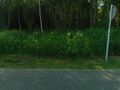
The hash is a few meters off a bicycle path in Kropswolde. There are some trees there and it should be pretty easy to reach.
Participants
Plans
I asked a few friends if they were interested in joining, but they already had other plans. So I decided to go on my own. It's just under 20 km, so it's a nice distance to do by bike.
Expedition
Due to my health, I have been sitting inside for about a year now. I could have gone outside for a walk, or with my bike, but I have rarely done that. So when this geohash was in such a well reachable spot, at just about the perfect distance to get some excercise without overdoing it, I felt I had to go. So I did. I planned to post a video about it on YouTube, so I packed my camera and lapel microphone. Bicycle repair materials are always in there, I never take them out (except when I use them). I packed some food, because you never want to be without food on a trip. It was very sunny, but I packed a jacket anyway, because you never know what will happen.
So that sounds like I was well prepared, right? Well, I also forgot several things, unfortunately. Somehow I had not taken any water with me. It's not the worst thing in the world, but on a sunny day it would have been nice (and healthy) to drink some water. Also, even though I packed the voice recorder for the lapel mic, I forgot to pack the mic itself. So that was just dumb of me.
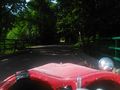
The road from my house to the hash was very nice. The sunny weather obviously helped, but aside from that I also enjoyed the variation of the scenery a lot. There's parts with farmland where you can view really far. And other parts with more trees. Some streams and canals with nice bridges. I enjoyed it a lot.
When I reached the hash, I recorded a video for YouTube, as planned. (I didn't do any recordings during the trip.) I couldn't be bothered to set up my "real" camera, so I just did a hand held recording on my phone. Because I didn't have the lapel mic, I just hoped that the audio quality would be acceptable. Turns out it's not great, but better than I expected and I would indeed call it acceptable. So that was nice.
On the way back I encountered another guy in a bike similar to mine. So we had a chat about bikes (somehow that's what people with those bikes always talk about) and we cycled a part of the way together. That was fun as well.
So now I'm back home and I've do some editing of the recordings and uploaded the result. Note that it's in Dutch.
Now that I'm writing this report, I see that nobody has filed an attempt yet for this day. So the fact that my friends had other plans may grant me the last man standing achievement. That'd be pretty awesome. I'll have to check back to see if that doesn't change. Update: another expedition was reported for this day, so I'm not getting the achievement. Ah well.
Photos
The hash is a few meters this way
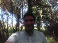
I reached the hash
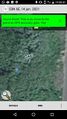
No really, I reached the hash
Some trees
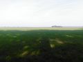
Some fields
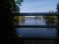
Some water
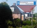
I can't seem to find the community center...


Achievements
Shevek earned the Land geohash achievement
|
Shevek earned the Bicycle geohash achievement
|