Difference between revisions of "2021-08-12 48 7"
From Geohashing
(Create expedition) |
|||
| (2 intermediate revisions by 2 users not shown) | |||
| Line 11: | Line 11: | ||
== Plans == | == Plans == | ||
| − | I will cycle from Sélestat to Molsheim in the afternoon. I plan to stop at the coordinates at about 13: | + | I will cycle from Sélestat to Molsheim in the afternoon. I plan to stop at the coordinates at about 13:15 before continuing my way. |
| + | |||
| + | == Expedition == | ||
| + | The coordinates were located in a small clearing in the middle of a vineyard, just outside Dambach-la-Ville. It took me 25 minutes to cycle there from Sélestat. | ||
| + | |||
| + | After recording proof, I continued on the EuroVelo 5 to Molsheim. I stopped at a café to eat the customary ice cream and replenish my bidons. Then I followed the Canal de la Bruche to Strasbourg and went home by train. | ||
| + | |||
| + | == Photos == | ||
| + | <gallery> | ||
| + | Image:2021-08-12 48 7 01.jpg | In Dambach-la-Ville | ||
| + | Image:2021-08-12 48 7 02.jpg | Cycling on the EuroVelo 5 | ||
| + | Image:2021-08-12 48 7 03.jpg | My bicycle near the geohash | ||
| + | Image:2021-08-12 48 7 04.jpg | The geohash | ||
| + | Image:2021-08-12 48 7 05.png | Coordinates reached | ||
| + | Image:2021-08-12 48 7 06.jpg | Stupid grin | ||
| + | Image:2021-08-12 48 7 07.jpg | Surroundings | ||
| + | Image:2021-08-12 48 7 08.jpg | Continuing on the EuroVelo 5 | ||
| + | </gallery> | ||
| + | |||
| + | == Achievements == | ||
| + | {{#vardefine:ribbonwidth|100%}} | ||
| + | {{land geohash | ||
| + | | latitude = 48 | ||
| + | | longitude = 7 | ||
| + | | date = 2021-08-12 | ||
| + | | name = [[User:Baarde|Baarde]] | ||
| + | }} | ||
| + | {{bicycle geohash | ||
| + | | latitude = 48 | ||
| + | | longitude = 7 | ||
| + | | date = 2021-08-12 | ||
| + | | name = [[User:Baarde|Baarde]] | ||
| + | | distance = 75 km | ||
| + | | bothways = true | ||
| + | }} | ||
__NOTOC__ | __NOTOC__ | ||
[[Category:Expeditions]] | [[Category:Expeditions]] | ||
| + | [[Category:Expeditions with photos]] | ||
| + | [[Category:Coordinates reached]] | ||
| + | {{location|FR|67}} | ||
Latest revision as of 11:37, 16 August 2021
| Thu 12 Aug 2021 in 48,7: 48.3285096, 7.4318147 geohashing.info google osm bing/os kml crox |
Location
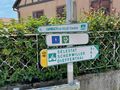
In a vineyard near Dambach-la-Ville.
Participants
Plans
I will cycle from Sélestat to Molsheim in the afternoon. I plan to stop at the coordinates at about 13:15 before continuing my way.
Expedition
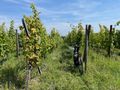
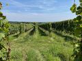
The coordinates were located in a small clearing in the middle of a vineyard, just outside Dambach-la-Ville. It took me 25 minutes to cycle there from Sélestat.
After recording proof, I continued on the EuroVelo 5 to Molsheim. I stopped at a café to eat the customary ice cream and replenish my bidons. Then I followed the Canal de la Bruche to Strasbourg and went home by train.
Photos
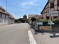
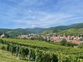
In Dambach-la-Ville
Cycling on the EuroVelo 5
My bicycle near the geohash
The geohash
Coordinates reached
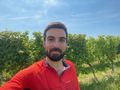
Stupid grin
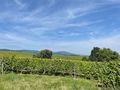
Surroundings
Continuing on the EuroVelo 5


Achievements
Baarde earned the Land geohash achievement
|
Baarde earned the Bicycle geohash achievement
|