Difference between revisions of "2008-07-05 32 -110"
imported>Tjtrumpet2323 m (→Photos: making into a gallery) |
m |
||
| (5 intermediate revisions by 5 users not shown) | |||
| Line 1: | Line 1: | ||
| + | {{meetup graticule | ||
| + | | map=<map lat="32" lon="-110" date="2008-07-05" /> | ||
| + | | lat=32 | ||
| + | | lon=-110 | ||
| + | | date=2008-07-05 | ||
| + | }} | ||
| + | |||
== Story == | == Story == | ||
| Line 9: | Line 16: | ||
I got a lot of strange looks by the people in passing cars, but I had a fun time. There was an empty lot a few blocks west, but I did not have proper foot attire to safely explore. | I got a lot of strange looks by the people in passing cars, but I had a fun time. There was an empty lot a few blocks west, but I did not have proper foot attire to safely explore. | ||
| − | + | ===Question=== | |
| + | Currently, the map above is showing a completely different location for that day's geohash, way over in the southeast corner of the graticule. The [[32,-111]] geohash is closer to Tucson, but still certainly not at the intersection you described. Any idea how this happened? --[[User:KarMann|KarMann]] 02:38, 4 November 2008 (UTC) | ||
== Photos == | == Photos == | ||
| − | <gallery widths="160px" align=center perrow= | + | <gallery widths="160px" align=center perrow="3"> |
Image:5July08Tucson1.jpg | Monsoon cloud | Image:5July08Tucson1.jpg | Monsoon cloud | ||
Image:5July08Tucson2.jpg | The spot | Image:5July08Tucson2.jpg | The spot | ||
| Line 21: | Line 29: | ||
</gallery> | </gallery> | ||
| − | + | [[Category:Expeditions]] | |
| − | [[Category: | ||
[[Category:Expeditions with photos]] | [[Category:Expeditions with photos]] | ||
| + | [[Category:Coordinates reached]] | ||
| + | [[Category:Expedition without GPS]] | ||
| + | {{location|US|AZ|PM}} | ||
Latest revision as of 21:22, 2 March 2020
| Sat 5 Jul 2008 in 32,-110: 32.1489437, -110.9212957 geohashing.info google osm bing/os kml crox |
Story
Today's geohash was just east of the intersection of S. Masterson Ave. and E. Drexel Rd. in South Tucson. It's the first Saturday geohash that I can recall being in the city. I grabbed an Eegee's drink (kind of like a slushy but far superior) and arrived at exactly 3:58 PM. I waited till I was finished my drink at 4:30, but no one showed up. A man walked by, but I'm pretty positive he wasn't a fellow geohasher.
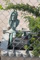
Without a GPS device, I had to rely on Google maps. The spot looked like it was right on the fence of the house by the mailbox. in that space was a fake mallard duck, a bust of a Native American, a somewhat offensive "Lazy Mexican" statue, and a little wagon.
The monsoon clouds to the northeast were amazing and gigantic. A beautiful sight to see in person.
I got a lot of strange looks by the people in passing cars, but I had a fun time. There was an empty lot a few blocks west, but I did not have proper foot attire to safely explore.
Question
Currently, the map above is showing a completely different location for that day's geohash, way over in the southeast corner of the graticule. The 32,-111 geohash is closer to Tucson, but still certainly not at the intersection you described. Any idea how this happened? --KarMann 02:38, 4 November 2008 (UTC)
Photos
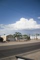
Monsoon cloud
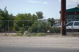
The spot
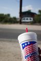
Eegee's 24 oz. flavor of the month
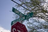
Nearby intersection
Stuff at the spot

Mike fighting off the hot desert sun


