Difference between revisions of "2021-10-29 51 10"
| Line 22: | Line 22: | ||
== Photos == | == Photos == | ||
| − | |||
<gallery> | <gallery> | ||
Image:2021-10-29_51_10_001.jpg|Approaching the field - some 25 meters to the hash... | Image:2021-10-29_51_10_001.jpg|Approaching the field - some 25 meters to the hash... | ||
| Line 34: | Line 33: | ||
[[Category:Expeditions with photos]] | [[Category:Expeditions with photos]] | ||
[[Category:Coordinates reached]] | [[Category:Coordinates reached]] | ||
| − | |||
{{location|DE|TH|EIC}} | {{location|DE|TH|EIC}} | ||
Latest revision as of 16:41, 29 October 2021
| Fri 29 Oct 2021 in 51,10: 51.2311175, 10.0829573 geohashing.info google osm bing/os kml crox |
Location
On a field east of Kella
Participants
Plans
The hash is located on the edge of a field, which I hope to be a harvested corn field, so I can get the few (maybe only some ten) meters onto it, without causing any destruction...
Expedition
On my day off I drove to Kella and parked my car only some 40 meters from the hash. Had to walk only a little to get onto the field, which was indeed harvested and in fact I didn't even had to enter it, to get a 5 meter accuracy. There was no mobile phone connection in this area, so I was lucky to have the hash-coordinates saved on my Garmin Etrex 20! Nothing exciting today, so this is all for the report...
Photos
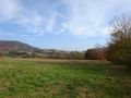
Approaching the field - some 25 meters to the hash...
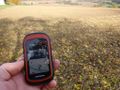
Five meters to the hash from here

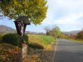
The hasher at the hash location
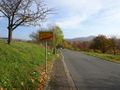
Near the hash location
The hash was on the field to the left


