Difference between revisions of "2008-07-07 47 12"
imported>Fedora m (2008-07-08 47 12 moved to 2008-07-07 47 12: Wrong date!) |
m (fix, sorry) |
||
| (6 intermediate revisions by 5 users not shown) | |||
| Line 8: | Line 8: | ||
==About== | ==About== | ||
| − | + | {{egl|2008-07-07|47|12|text=47.950188°, 12.873372°}} | |
This hashpoint was located east of Hof in the [[Rosenheim, Germany]] graticule, in a small forest. The nearest road passes under a railroad bridge - from there, a dirt road leads to the forest, and a tractor path can get you close to the hashpoint. | This hashpoint was located east of Hof in the [[Rosenheim, Germany]] graticule, in a small forest. The nearest road passes under a railroad bridge - from there, a dirt road leads to the forest, and a tractor path can get you close to the hashpoint. | ||
| Line 14: | Line 14: | ||
==Attending== | ==Attending== | ||
| − | [[User:Fedora|Jeremy]] will attend | + | [[User:Fedora|Jeremy]] will attend, arriving by bicycle from Waging in the late afternoon. |
==Expeditions== | ==Expeditions== | ||
| Line 26: | Line 26: | ||
Image:7708hash2.JPG | I wonder how long this will stay here? | Image:7708hash2.JPG | I wonder how long this will stay here? | ||
</gallery> | </gallery> | ||
| + | |||
| + | [[Category:Expeditions]] | ||
| + | [[Category:Expeditions with photos]] | ||
| + | [[Category:Coordinates not reached]] | ||
| + | [[Category:Not reached - No public access]] | ||
| + | {{location|DE|BY|TS}} | ||
Latest revision as of 18:52, 18 January 2022
| Mon 7 Jul 2008 in 47,12: 47.9501883, 12.8733725 geohashing.info google osm bing/os kml crox |
Contents
About
This hashpoint was located east of Hof in the Rosenheim, Germany graticule, in a small forest. The nearest road passes under a railroad bridge - from there, a dirt road leads to the forest, and a tractor path can get you close to the hashpoint.
Attending
Jeremy will attend, arriving by bicycle from Waging in the late afternoon.
Expeditions
Jeremy 17:45
I set out from Waging am See by bike (with my towel, of course) at about 17:00. The weather was miserable, alternating between light and heavy rain for the entire trip. When I arrived in Hof, I had to guess the rest of the route, because I didn't have a map or a GPS unit. However, I found a dirt road that ran parallel to the railroad tracks toward the woods. From there, a tractor path ran through the woods, connecting the fields north and south of the geohash. A fence on the east side of the path kept me about 500 feet from the hash itself - so I got as close as I could before snapping some pictures, enjoying a locally brewed beer, and heading back. I left behind some broken sticks spelling out "xkcd" for anyone who should stumble upon them.
- Rosenheim 07.07.2008: Jeremy
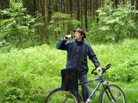
Enjoying a Schörnramer Festweiße in the rain.
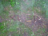
I wonder how long this will stay here?

