Difference between revisions of "2021-11-27 49 8"
(New Expedition Report) |
m |
||
| (4 intermediate revisions by 2 users not shown) | |||
| Line 1: | Line 1: | ||
| − | + | {{meetup graticule | |
| − | |||
| − | |||
| − | |||
| − | |||
| − | |||
| − | |||
| − | |||
| − | |||
| lat=49 | | lat=49 | ||
| lon=8 | | lon=8 | ||
| Line 13: | Line 5: | ||
}}<!-- edit as necessary --> | }}<!-- edit as necessary --> | ||
__NOTOC__ | __NOTOC__ | ||
| + | |||
== Location == | == Location == | ||
| − | + | ||
| + | In the Pfälzerwald near Frankweiler. | ||
== Participants == | == Participants == | ||
| − | + | ||
| − | + | [[User:DLichti|DLichti]] and some members of his family. | |
== Plans == | == Plans == | ||
| − | + | ||
| + | Take the car to Frankweiler, go for a walk to the Orensfels, find the location on the way back. | ||
== Expedition == | == Expedition == | ||
| − | |||
| − | + | We reached Frankweiler at around 14:00 in the afternoon. | |
| − | + | It was a chilly day with low clouds and a mix of rain and snow. | |
| + | |||
| + | We passed by the Landauer Hütte near Neuscharfeneck castle. | ||
| + | From there, a path leads up to the Orensfels. | ||
| + | Up in the hills, the forest floor was covered by the first snow of the winter. | ||
| + | |||
| + | Near the Orensfels, there is a paraglider launch site. | ||
| + | From there and from the view point on the rock, there was a nice vista over the Queich valley. | ||
| + | Especially with the sun peeking through the clouds at some moments. | ||
| + | |||
| + | We took a different way back to Frankweiler. | ||
| + | Just before arriving at the small town, we had to go down a hillside to find the exact location. | ||
| + | All of my family wanted to follow me and we did it with only some minor accidents. | ||
| + | I had to climb up and down a bit until I was satified with my position. | ||
| + | |||
| + | At around 16:00, we came back to the place where we had left the car and drove home. | ||
== Photos == | == Photos == | ||
| Line 34: | Line 43: | ||
--> | --> | ||
<gallery perrow="5"> | <gallery perrow="5"> | ||
| + | Image:2021-11-27 49-8 duddefliecher.jpeg|view over the Queich valley | ||
| + | Image:2021-11-27 49-8 hillside.jpeg|the hillside | ||
| + | Image:2021-11-27 49-8 location.jpeg|the location | ||
| + | Image:2021-11-27 49-8 proof.png|proof | ||
</gallery> | </gallery> | ||
| − | |||
| − | |||
| − | |||
| − | |||
| − | |||
| − | |||
| − | |||
| − | |||
| − | |||
| − | |||
| − | |||
| − | |||
| − | |||
| − | |||
| − | |||
| − | |||
| − | |||
| − | |||
[[Category:Expeditions]] | [[Category:Expeditions]] | ||
| − | + | [[Category:Coordinates reached]] | |
[[Category:Expeditions with photos]] | [[Category:Expeditions with photos]] | ||
| − | + | {{location|DE|RP|SÜW}} | |
| − | |||
| − | |||
| − | |||
| − | |||
| − | |||
| − | |||
| − | |||
| − | |||
| − | |||
| − | |||
| − | |||
| − | |||
| − | |||
| − | |||
| − | |||
| − | |||
| − | |||
| − | |||
| − | |||
| − | |||
| − | |||
| − | |||
| − | |||
Latest revision as of 13:47, 28 November 2021
| Sat 27 Nov 2021 in 49,8: 49.2356061, 8.0503141 geohashing.info google osm bing/os kml crox |
Location
In the Pfälzerwald near Frankweiler.
Participants
DLichti and some members of his family.
Plans
Take the car to Frankweiler, go for a walk to the Orensfels, find the location on the way back.
Expedition
We reached Frankweiler at around 14:00 in the afternoon. It was a chilly day with low clouds and a mix of rain and snow.
We passed by the Landauer Hütte near Neuscharfeneck castle. From there, a path leads up to the Orensfels. Up in the hills, the forest floor was covered by the first snow of the winter.
Near the Orensfels, there is a paraglider launch site. From there and from the view point on the rock, there was a nice vista over the Queich valley. Especially with the sun peeking through the clouds at some moments.
We took a different way back to Frankweiler. Just before arriving at the small town, we had to go down a hillside to find the exact location. All of my family wanted to follow me and we did it with only some minor accidents. I had to climb up and down a bit until I was satified with my position.
At around 16:00, we came back to the place where we had left the car and drove home.
Photos
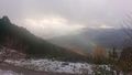
view over the Queich valley
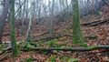
the hillside
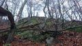
the location
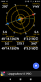
proof


