Difference between revisions of "2022-02-16 -37 149"
Felix Dance (talk | contribs) m (→Expedition) |
m |
||
| (One intermediate revision by one other user not shown) | |||
| Line 114: | Line 114: | ||
[[Category:Expeditions with photos]] | [[Category:Expeditions with photos]] | ||
[[Category:Coordinates not reached]] | [[Category:Coordinates not reached]] | ||
| + | [[Category:Not reached - Mother Nature]] | ||
| + | {{location|AU|NSW|BV}} | ||
Latest revision as of 11:56, 14 March 2022
| Wed 16 Feb 2022 in -37,149: -37.1770642, 149.9049489 geohashing.info google osm bing/os kml crox |
Location
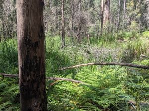
Past a creek in the thick bush of the Kiah Valley, south of Eden.
Participants
Expedition
Alex: Possible geohash for Lachie ~45km ride each way doesn't help the vic streak
Matt: Lachie counts as a Victorian
Lachie: It was a slow start But in finally hitting the road -Links GPS tracker-
John: lachie looks very close
Lachie: I am...
Only 200m to go But it's dense And sharp
John: you can do it!
Lachie:
This creek is more significant than I anticipated
John: traversable?
Steve: Ooh that does look exciting
Lachie: I give up
Steve: oh no!
Alex: You probably won't want to do this, but have you considered going in further from the north? Might avoid the creek
Lachie: I considered it But it would still be incredibly thick bush
Matt: Condolences Lachie! 😞
Lachie: And the creek doesn't follow the blue line on the map so it was hard to make a plan I'm at the Kiah store having lunch now
Matt: Kiah Valley Iced Coffee?
Lachie: The one and only I'm taking a different way back to Burragate The Snake Track
Ed: snek trek
Felix: Sorry to hear that Lachie. Sounds like an impressive expedition though
Tracklog
Photos
Achievements
Lachie earned the My kingdom for a boat consolation prize
|


