Difference between revisions of "2022-02-27 50 11"
ScepticAnna (talk | contribs) (→Photos) |
(Categories) |
||
| (6 intermediate revisions by one other user not shown) | |||
| Line 28: | Line 28: | ||
== Expedition == | == Expedition == | ||
<!-- how it all turned out. your narrative goes here. --> | <!-- how it all turned out. your narrative goes here. --> | ||
| + | The morning was cold enough to achieve a frozen geohash, but cycling 20 km in below freezing temperatures is a bit too extreme for me. I waited until it had warmed up a bit. Even so, some parts of the route were very cold and windy. Even on the way back, one small stream was still half frozen over! Otherwise, it was very nice, sunny weather. | ||
| + | |||
| + | I was very pleased to see that multiple new bike paths have been built along the expedition route since I last cycled in that region. Even so, I made the mistake to follow my GPS instead of the signposted bike path when I left Mellingen towards Oettern. The GPS sent me down some gnarly, steep hiking paths that would probably have been fun for mountain bikers, but forced me to get off and walk. | ||
| + | |||
| + | As predicted, the point was in a field; the last few hundred meters of the approach were very muddy paths. The point itself was pretty boring and I called the 4 m shot close enough, because I didn't want to trample the young plants in the field. | ||
| + | |||
| + | On the way back, I followed the official bike path and had a very pleasant ride home. | ||
| + | === Notable flora and fauna === | ||
| + | * multiple [https://en.wikipedia.org/wiki/Red_kite Red Kites] hunting on newly planted fields | ||
| + | * [https://en.wikipedia.org/wiki/Eurasian_coot Eurasian Coots] on an aquaculture pond | ||
| + | * off-leash dogs on the bike path (argh, why?!) | ||
| + | * a strip of last years sunflowers at the edge of a field that were never harvested (maybe a distraction for birds?) | ||
== Tracklog == | == Tracklog == | ||
<!-- if your GPS device keeps a log, you may use Template:Tracklog, post a link here, or both --> | <!-- if your GPS device keeps a log, you may use Template:Tracklog, post a link here, or both --> | ||
| + | {{tracklog | 2022-02-27 50 11 ANNA.gpx}} | ||
== Photos == | == Photos == | ||
| Line 39: | Line 52: | ||
Image:2022-02-27_50_11_Anna_approach_rs.JPG | Approach to the point | Image:2022-02-27_50_11_Anna_approach_rs.JPG | Approach to the point | ||
Image:2022-02-27_50_11_Anna_mud_rs.JPG | Which is worse: frozen or liquid mud? | Image:2022-02-27_50_11_Anna_mud_rs.JPG | Which is worse: frozen or liquid mud? | ||
| − | Image:2022-02-27_50_11_Anna_proof_rs.JPG | Proof, or close enough | + | Image:2022-02-27_50_11_Anna_proof_rs.JPG | Proof, or close enough (ignore the odometer, I forgot to reset) |
Image:2022-02-27_50_11_Anna_point_rs.JPG | View from the point | Image:2022-02-27_50_11_Anna_point_rs.JPG | View from the point | ||
Image:2022-02-27_50_11_Anna_icestream_rs.JPG | Stream still half frozen over after noon | Image:2022-02-27_50_11_Anna_icestream_rs.JPG | Stream still half frozen over after noon | ||
| Line 48: | Line 61: | ||
<!-- Add any achievement ribbons you earned below, or remove this section --> | <!-- Add any achievement ribbons you earned below, or remove this section --> | ||
| − | |||
| − | |||
| − | |||
| − | |||
| − | |||
| − | |||
| − | |||
| − | |||
| − | |||
| − | |||
| − | |||
| − | |||
| − | |||
| − | |||
[[Category:Expeditions]] | [[Category:Expeditions]] | ||
| − | |||
[[Category:Expeditions with photos]] | [[Category:Expeditions with photos]] | ||
| − | |||
| − | |||
| − | |||
| − | |||
| − | |||
[[Category:Coordinates reached]] | [[Category:Coordinates reached]] | ||
| − | |||
| − | |||
| − | |||
| − | |||
| − | |||
| − | |||
| − | |||
| − | |||
| − | |||
| − | |||
| − | |||
| − | |||
| − | |||
| − | |||
| − | |||
| − | |||
| − | |||
| − | |||
| − | |||
| − | |||
| − | |||
{{location|DE|TH|AP}} | {{location|DE|TH|AP}} | ||
Latest revision as of 13:09, 1 March 2022
| Sun 27 Feb 2022 in 50,11: 50.9300790, 11.3497674 geohashing.info google osm bing/os kml crox |
Location
In a field near Oettern. Looks like it's close to a path, so it should be reachable.
Participants
Plans
I'm planning to go there by bike from Jena, start time depends on the temperature. Anna
Expedition
The morning was cold enough to achieve a frozen geohash, but cycling 20 km in below freezing temperatures is a bit too extreme for me. I waited until it had warmed up a bit. Even so, some parts of the route were very cold and windy. Even on the way back, one small stream was still half frozen over! Otherwise, it was very nice, sunny weather.
I was very pleased to see that multiple new bike paths have been built along the expedition route since I last cycled in that region. Even so, I made the mistake to follow my GPS instead of the signposted bike path when I left Mellingen towards Oettern. The GPS sent me down some gnarly, steep hiking paths that would probably have been fun for mountain bikers, but forced me to get off and walk.
As predicted, the point was in a field; the last few hundred meters of the approach were very muddy paths. The point itself was pretty boring and I called the 4 m shot close enough, because I didn't want to trample the young plants in the field.
On the way back, I followed the official bike path and had a very pleasant ride home.
Notable flora and fauna
- multiple Red Kites hunting on newly planted fields
- Eurasian Coots on an aquaculture pond
- off-leash dogs on the bike path (argh, why?!)
- a strip of last years sunflowers at the edge of a field that were never harvested (maybe a distraction for birds?)
Tracklog
Photos
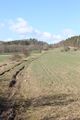
Approach to the point

Which is worse: frozen or liquid mud?

Proof, or close enough (ignore the odometer, I forgot to reset)

View from the point

Stream still half frozen over after noon


