Difference between revisions of "2022-03-06 -37 143"
m (subst-ing) |
|||
| (3 intermediate revisions by 2 users not shown) | |||
| Line 1: | Line 1: | ||
<!-- If you did not specify these parameters in the template, please substitute appropriate values for IMAGE, LAT, LON, and DATE (YYYY-MM-DD format) | <!-- If you did not specify these parameters in the template, please substitute appropriate values for IMAGE, LAT, LON, and DATE (YYYY-MM-DD format) | ||
| − | |||
| − | |||
Remove this section if you don't want an image at the top (left) of your report. You should remove the "Image:" or "File:" | Remove this section if you don't want an image at the top (left) of your report. You should remove the "Image:" or "File:" | ||
| Line 8: | Line 6: | ||
And DON'T FORGET to add your expedition and the best photo you took to the gallery on the Main Page! We'd love to read your report, but that means we first have to discover it! :) | And DON'T FORGET to add your expedition and the best photo you took to the gallery on the Main Page! We'd love to read your report, but that means we first have to discover it! :) | ||
-->{{meetup graticule | -->{{meetup graticule | ||
| − | | lat= | + | | lat=-37 |
| − | | lon= | + | | lon=143 |
| − | | date= | + | | date=2022-03-06 |
}}<!-- edit as necessary --> | }}<!-- edit as necessary --> | ||
| + | |||
| + | |||
| + | |||
__NOTOC__ | __NOTOC__ | ||
== Location == | == Location == | ||
| Line 17: | Line 18: | ||
== Participants == | == Participants == | ||
| + | |||
*[[User:Stevage|Stevage]] | *[[User:Stevage|Stevage]] | ||
*EB | *EB | ||
*KP | *KP | ||
| − | |||
== Expedition == | == Expedition == | ||
| + | [[File:PXL_20220306_054023505.jpg|400px|thumb|left]] | ||
The three of us were driving back from a hiking trip around Mt Buangor. I'd seen the geohash location, and was a bit undecided. On the one hand, it looked pretty dubious: 870m from the road inside a farm, further than I really want to go. On the other, it was such a short detour, it seemed silly not to at least check it out. | The three of us were driving back from a hiking trip around Mt Buangor. I'd seen the geohash location, and was a bit undecided. On the one hand, it looked pretty dubious: 870m from the road inside a farm, further than I really want to go. On the other, it was such a short detour, it seemed silly not to at least check it out. | ||
| Line 38: | Line 40: | ||
Image:2020-##-## ## ## Alpha.jpg | Witty Comment | Image:2020-##-## ## ## Alpha.jpg | Witty Comment | ||
--> | --> | ||
| − | <gallery | + | <gallery> |
| + | File:PXL_20220306_054023505.jpg | ||
| + | File:PXL_20220306_054106007.jpg | ||
</gallery> | </gallery> | ||
| Line 44: | Line 48: | ||
{{#vardefine:ribbonwidth|800px}} | {{#vardefine:ribbonwidth|800px}} | ||
<!-- Add any achievement ribbons you earned below, or remove this section --> | <!-- Add any achievement ribbons you earned below, or remove this section --> | ||
| − | |||
| − | |||
| − | |||
| − | |||
| − | |||
| − | |||
| − | |||
| − | |||
| − | |||
| − | |||
| − | |||
| − | |||
| − | |||
[[Category:Expeditions]] | [[Category:Expeditions]] | ||
| Line 63: | Line 54: | ||
[[Category:Coordinates not reached]] | [[Category:Coordinates not reached]] | ||
[[Category:Not reached - No public access]] | [[Category:Not reached - No public access]] | ||
| + | {{location|AU|VIC|PY}} | ||
Latest revision as of 20:45, 24 May 2024
| Sun 6 Mar 2022 in -37,143: -37.4424864, 143.6064815 geohashing.info google osm bing/os kml crox |
Location
In a farm, not far from Beaufort.
Participants
- Stevage
- EB
- KP
Expedition
The three of us were driving back from a hiking trip around Mt Buangor. I'd seen the geohash location, and was a bit undecided. On the one hand, it looked pretty dubious: 870m from the road inside a farm, further than I really want to go. On the other, it was such a short detour, it seemed silly not to at least check it out.
After a quick bakery stop in Beaufort, we headed off. The road was nice and quiet, uneventful other than a few big clumps of hay apparently fallen off the back of a truck. "HAY!" I yelled. No one laughed.
There was a great view of wind turbines on the hills.
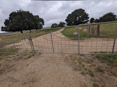
We stopped, got out, had a look at the approach. There was a gate, not locked, but not inviting either.
There was nothing exactly stopping me going in, but I didn't particularly feel like an awkward conversation with a farmer, and there was nothing particularly enticing about the spot.
We got back in the car and vroomed off.


