Difference between revisions of "2022-03-14 -37 145"
(→Photos) |
m (subst-ing) |
||
| (One intermediate revision by the same user not shown) | |||
| Line 1: | Line 1: | ||
{{meetup graticule | {{meetup graticule | ||
| − | | lat= | + | | lat=-37 |
| − | | lon= | + | | lon=145 |
| − | | date= | + | | date=2022-03-14 |
}}<!-- edit as necessary --> | }}<!-- edit as necessary --> | ||
__NOTOC__ | __NOTOC__ | ||
| Line 37: | Line 37: | ||
[[Category:Coordinates not reached]] | [[Category:Coordinates not reached]] | ||
[[Category:Not reached - No public access]] | [[Category:Not reached - No public access]] | ||
| + | {{location|AU|VIC|YR}} | ||
Latest revision as of 20:45, 24 May 2024
| Mon 14 Mar 2022 in -37,145: -37.9318687, 145.3233489 geohashing.info google osm bing/os kml crox |
Location
In bush in Lysterfield Park
Participants
Expedition
Returning from a family visit down the peninsula, the point in Lysterfield Park seemed a nice detour. I used to live much closer to there and went mountain biking a few times. But it has been years! Would it all be changed? Would it still be as full of kangaroos as I remember?
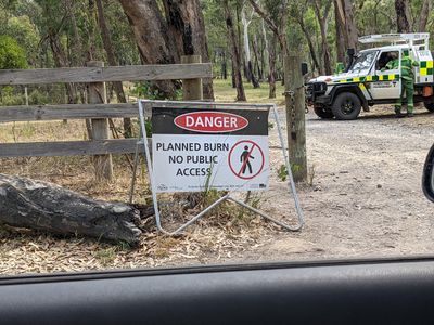
We drove up Reynolds Rd, a steep gravel road that the car didn't particularly appreciate. Then we saw the bad news: there was a controlled burn happening. Government workers were by the gate looking very watchful.
There are certain kinds of signs I'd be happy to ignore. A warning of potentially being incinerated in a giant wall of flame is not one of them.
I then turned my attention to checking out all the hard rubbish that was put out for collection along Reynolds Road, and successfully acquired quite a nice looking bucket. Black, solid, not too big, but bound to be useful in our forthcoming house move.
