Difference between revisions of "2022-04-01 36 -114"
From Geohashing
Felix Dance (talk | contribs) ([retro picture]At the hash) |
m (→Participants) |
||
| (9 intermediate revisions by 4 users not shown) | |||
| Line 1: | Line 1: | ||
| − | + | [[Image:{{{image|2022-04-01_36_-114_Felix Dance_1648939496470.jpg}}}|thumb|left]] | |
| − | + | {{meetup graticule | |
| − | |||
| − | |||
| − | |||
| − | |||
| − | |||
| − | |||
| lat=36 | | lat=36 | ||
| lon=-114 | | lon=-114 | ||
| Line 14: | Line 8: | ||
__NOTOC__ | __NOTOC__ | ||
== Location == | == Location == | ||
| − | + | In the Nevada desert off the highway to Las Vegas. | |
== Participants == | == Participants == | ||
| − | + | *[[User:Felix Dance|Felix Dance]] | |
| − | + | *[[User:Ruth|Ruth]] | |
| − | |||
| − | |||
| − | |||
== Expedition == | == Expedition == | ||
| − | + | An excellent, easy geohash. We were driving down the highway towards Las Vegas, saw that it was on the way and that there was a fortuitous service road granting access, and off we went. | |
| + | We parked our little campervan on the dirt road closest to the hash and tromped 150m over the rocky ground to get there. Took a few photos and returned with minimal incidents. | ||
*Geohash reached! -- [[User:Felix Dance|Felix Dance]] ([[User talk:Felix Dance|talk]]) [https://openstreetmap.org/?mlat=36.09949680&mlon=-115.18377920&zoom=16 @36.0995,-115.1838] 16:44, 2 April 2022 (MDT) | *Geohash reached! -- [[User:Felix Dance|Felix Dance]] ([[User talk:Felix Dance|talk]]) [https://openstreetmap.org/?mlat=36.09949680&mlon=-115.18377920&zoom=16 @36.0995,-115.1838] 16:44, 2 April 2022 (MDT) | ||
| + | |||
== Tracklog == | == Tracklog == | ||
<!-- if your GPS device keeps a log, you may use Template:Tracklog, post a link here, or both --> | <!-- if your GPS device keeps a log, you may use Template:Tracklog, post a link here, or both --> | ||
| Line 38: | Line 31: | ||
Image:2022-04-01_36_-114_Felix Dance_1648939496470.jpg|At the hash | Image:2022-04-01_36_-114_Felix Dance_1648939496470.jpg|At the hash | ||
| + | |||
| + | Image:2022-04-01_36_-114_Felix Dance_1648939824079.jpg|Panorama from the hash | ||
| + | |||
| + | Image:2022-04-01_36_-114_Felix Dance_1648939837044.jpg|Our parked van | ||
| + | |||
| + | Image:2022-04-01_36_-114_Felix Dance_1648939852548.jpg|Desert | ||
| + | |||
| + | Image:2022-04-01_36_-114_Felix Dance_1648939867387.jpg|GPS proof | ||
</gallery> | </gallery> | ||
| Line 44: | Line 45: | ||
<!-- Add any achievement ribbons you earned below, or remove this section --> | <!-- Add any achievement ribbons you earned below, or remove this section --> | ||
| − | |||
| − | |||
| − | |||
| − | |||
| − | |||
| − | |||
| − | |||
| − | |||
| − | |||
| − | |||
| − | |||
| − | |||
| − | |||
| − | |||
[[Category:Expeditions]] | [[Category:Expeditions]] | ||
| − | + | [[Category:Expeditions with photos]] | |
| − | [[Category:Expeditions with photos]] | ||
| − | |||
| − | |||
| − | |||
| − | |||
| − | |||
[[Category:Coordinates reached]] | [[Category:Coordinates reached]] | ||
| − | + | {{location|US|NV|CL}} | |
| − | |||
| − | |||
| − | |||
| − | |||
| − | |||
| − | |||
| − | |||
| − | |||
| − | |||
| − | |||
| − | |||
| − | |||
| − | |||
| − | |||
| − | |||
| − | |||
| − | |||
Latest revision as of 12:49, 24 June 2024

| Fri 1 Apr 2022 in 36,-114: 36.7729124, -114.3780281 geohashing.info google osm bing/os kml crox |
Location
In the Nevada desert off the highway to Las Vegas.
Participants
Expedition
An excellent, easy geohash. We were driving down the highway towards Las Vegas, saw that it was on the way and that there was a fortuitous service road granting access, and off we went.
We parked our little campervan on the dirt road closest to the hash and tromped 150m over the rocky ground to get there. Took a few photos and returned with minimal incidents.
- Geohash reached! -- Felix Dance (talk) @36.0995,-115.1838 16:44, 2 April 2022 (MDT)
Tracklog
Photos
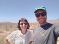
At the hash
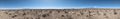
Panorama from the hash
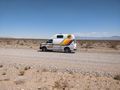
Our parked van
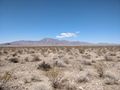
Desert
GPS proof


