Difference between revisions of "2022-04-18 -37 145"
([live picture]Success [https://openstreetmap.org/?mlat=-37.70923333&mlon=145.03973333&zoom=16 @-37.7092,145.0397]) |
(→Participants) |
||
| (15 intermediate revisions by 3 users not shown) | |||
| Line 1: | Line 1: | ||
| − | + | [[Image:2022-04-18_-37_145_stevage_1650279237117.jpg|thumb|left]] | |
| − | + | {{meetup graticule | |
| − | [[Image: | ||
| − | |||
| − | |||
| − | |||
| − | |||
| − | |||
| − | |||
| lat=-37 | | lat=-37 | ||
| lon=145 | | lon=145 | ||
| date=2022-04-18 | | date=2022-04-18 | ||
| − | }} | + | }} |
__NOTOC__ | __NOTOC__ | ||
== Location == | == Location == | ||
| − | + | In Bundoora Park Public Golf Course | |
| − | |||
== Participants == | == Participants == | ||
| − | + | * [[User:Stevage|Stevage]] | |
| − | + | * Laura K | |
| + | * [[User:Johnwrw|John]] | ||
== Plans == | == Plans == | ||
<!-- what were the original plans --> | <!-- what were the original plans --> | ||
| − | == Expedition == | + | == Expedition 1: Steve and Laura== |
| − | <!-- how it all | + | On a very soggy Easter Monday, Laura was dragged along to her first geohash. After considering various transport options to get there, such as me cycling and Laura PT'ng, we ended up with Laura tramming to near my place, and me driving together. |
| + | |||
| + | That should have been the easy bit. Somehow, two very distracted people ended up "meeting" at two very different locations, and hilarity continued to ensue for half an hour while I drove around to where I thought Laura was, misunderstanding a second time. It would be even funnier if we both worked in the spatial industry... | ||
| + | |||
| + | Driving was uneventful. I parked an arbitrary distance from the hash in order to at least do a token walk (500 metres each way, very token). The grass was very squishy. Surprisingly, the rain had not vanquished all golfers, with one foursome gamely gaming away. And there were ducks too. | ||
| + | |||
| + | I had expected to find the point in the middle of a fairway, but it seems the course has been slightly reconfigured and that area is now being rehabilitated as bush. Many little saplings in tree guards. Good luck trees, may you grow tall and proud! | ||
| + | |||
| + | As such we actually overshot slightly and had to squish back to the point, getting to it very quickly. We then squished off to the car in a roundabout fashion, and of course soon found ourselves at a pub. | ||
| + | |||
| + | === Photos === | ||
| + | |||
| + | |||
| + | <gallery> | ||
| + | File:PXL_20220418_013200799.jpg|Brave golfers. | ||
| + | File:PXL_20220418_013527701.jpg|Ducks! | ||
| + | File:PXL_20220418_013759127.jpg|Laura amongst a sea of saplings. Grow hard, trees, reach for the sky! | ||
| + | </gallery> | ||
| + | |||
| + | == Expedition 2: John== | ||
| + | I wasn't feeling brilliant, with a slight headache, but I thought a bit of exercise and fresh air would do me good, and the hash was the obvious direction to head in, even if I mightn't otherwise have gone for quite so much of a ride. Unlike the first expedition, I sensibly waited until the afternoon when the rain had cleared up a bit to have a go at the hash. I set off from Footscray on my bike a little after 2. It was a similar journey to the one for the [[2022-02-09 -37 145|February 9th geohash]], just having to travel marginally further up the Darebin Creek Trail at the end. | ||
| + | |||
| + | On the way, I passed a church in Thornbury that had a rather decrepit looking piano sitting outside, having obviously been exposed to the elements for some time. It was however brightly painted, with the slogan "Make a Joyful sound" adorning it. I was curious as to just how playable it would be given its dilapidated state, so I went over, lifted the lid, and discovered that, indeed, the keys themselves were not a pretty sight. About half the keys didn't function, including just about all the black ones, and naturally the tuning was very iffy as well. I made a valiant attempt to coax a joyful sound from it before I moved on, but it was a struggle. | ||
| + | |||
| + | Along the Darebin Creek Trail, at Olympic Park in Heidelberg West (so-called because it was established for the 1956 Olympics along with the Olympic Village right next to it), I saw a gang of ibises gathered on a sporting oval. What caught my eye is that they had mostly dark bodies, and thus didn't seem to be your standard white ibis/bin chicken. Later research indicated that these were in fact straw-necked ibises. | ||
| + | |||
| + | When I got to the golf course in Bundoora where the hash lay, I locked up my bike and crossed a fairway with care, making sure I wasn't going to be struck with any dimpled projectiles. There were a few golfers around but it was still quite quiet despite the rain having eased. I found the reveg area that Steve mentions above, and very soon after found the hash. I snapped a couple of pics and was on my way. | ||
| + | |||
| + | I had noticed on a previous visit to Bundoora Park the wide array of birdlife that it seems to support, and this impression was reaffirmed by this trip. I got quite close to a few trees that had parrots flapping about in them, both rainbow lorikeets and smaller mostly green parrots, that I didn't get a good enough look at to identify, and there were many other birds flying around and making bird noises. | ||
| + | |||
| + | The ride home was fairly uneventful, by this stage I was feeling better, the fresh air and exercise having done its job. A bit of drizzliness had returned however, so I got a bit damp, but not uncomfortably so. I finally returned home at around 5.30pm having done just over 50km of riding. | ||
== Tracklog == | == Tracklog == | ||
<!-- if your GPS device keeps a log, you may use Template:Tracklog, post a link here, or both --> | <!-- if your GPS device keeps a log, you may use Template:Tracklog, post a link here, or both --> | ||
| − | == Photos == | + | === Photos === |
| − | < | + | |
| − | Image: | + | |
| − | + | <gallery> | |
| − | + | ||
| + | |||
| + | Image:2022-04-18_-37_145_Johnwrw_1650423625790.jpg|Dilapidated piano | ||
| − | Image:2022-04-18_- | + | Image:2022-04-18_-37_145_Johnwrw_1650423651740.jpg|Some sad looking piano keys |
| + | |||
| + | Image:2022-04-18_-37_145_Johnwrw_1650423670039.jpg|Straw necked ibis | ||
| + | |||
| + | Image:2022-04-18_-37_145_Johnwrw_1650423682731.jpg|At the hash [https://openstreetmap.org/?mlat=-37.70922500&mlon=145.03975000&zoom=16 @-37.7092,145.0398] | ||
| + | |||
| + | Image:2022-04-18_-37_145_Johnwrw_1650423714941.jpg|GPS | ||
</gallery> | </gallery> | ||
== Achievements == | == Achievements == | ||
{{#vardefine:ribbonwidth|800px}} | {{#vardefine:ribbonwidth|800px}} | ||
| − | + | {{bicycle geohash | |
| − | |||
| − | |||
| − | |||
| − | |||
| − | + | | latitude = -37 | |
| + | | longitude = 145 | ||
| + | | date = 2022-04-18 | ||
| + | | name = [[User:johnwrw|John]] | ||
| + | | distance = 50.2 kms | ||
| + | | bothways = true | ||
| − | |||
| − | |||
| − | |||
| − | |||
| − | + | }} | |
| − | |||
[[Category:Expeditions]] | [[Category:Expeditions]] | ||
| − | |||
[[Category:Expeditions with photos]] | [[Category:Expeditions with photos]] | ||
| − | |||
| − | |||
| − | |||
| − | |||
| − | |||
[[Category:Coordinates reached]] | [[Category:Coordinates reached]] | ||
| − | + | {{location|AU|VIC|DA}} | |
| − | |||
| − | |||
| − | |||
| − | |||
| − | |||
| − | |||
| − | |||
| − | |||
| − | |||
| − | |||
| − | |||
| − | |||
| − | |||
| − | |||
| − | |||
| − | |||
| − | |||
Latest revision as of 03:16, 20 April 2022

| Mon 18 Apr 2022 in -37,145: -37.7092232, 145.0397539 geohashing.info google osm bing/os kml crox |
Location
In Bundoora Park Public Golf Course
Participants
Plans
Expedition 1: Steve and Laura
On a very soggy Easter Monday, Laura was dragged along to her first geohash. After considering various transport options to get there, such as me cycling and Laura PT'ng, we ended up with Laura tramming to near my place, and me driving together.
That should have been the easy bit. Somehow, two very distracted people ended up "meeting" at two very different locations, and hilarity continued to ensue for half an hour while I drove around to where I thought Laura was, misunderstanding a second time. It would be even funnier if we both worked in the spatial industry...
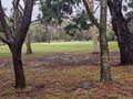
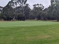
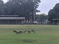
Driving was uneventful. I parked an arbitrary distance from the hash in order to at least do a token walk (500 metres each way, very token). The grass was very squishy. Surprisingly, the rain had not vanquished all golfers, with one foursome gamely gaming away. And there were ducks too.
I had expected to find the point in the middle of a fairway, but it seems the course has been slightly reconfigured and that area is now being rehabilitated as bush. Many little saplings in tree guards. Good luck trees, may you grow tall and proud!
As such we actually overshot slightly and had to squish back to the point, getting to it very quickly. We then squished off to the car in a roundabout fashion, and of course soon found ourselves at a pub.
Photos
Brave golfers.
Ducks!
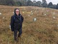
Laura amongst a sea of saplings. Grow hard, trees, reach for the sky!


Expedition 2: John
I wasn't feeling brilliant, with a slight headache, but I thought a bit of exercise and fresh air would do me good, and the hash was the obvious direction to head in, even if I mightn't otherwise have gone for quite so much of a ride. Unlike the first expedition, I sensibly waited until the afternoon when the rain had cleared up a bit to have a go at the hash. I set off from Footscray on my bike a little after 2. It was a similar journey to the one for the February 9th geohash, just having to travel marginally further up the Darebin Creek Trail at the end.
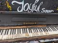
On the way, I passed a church in Thornbury that had a rather decrepit looking piano sitting outside, having obviously been exposed to the elements for some time. It was however brightly painted, with the slogan "Make a Joyful sound" adorning it. I was curious as to just how playable it would be given its dilapidated state, so I went over, lifted the lid, and discovered that, indeed, the keys themselves were not a pretty sight. About half the keys didn't function, including just about all the black ones, and naturally the tuning was very iffy as well. I made a valiant attempt to coax a joyful sound from it before I moved on, but it was a struggle.
Along the Darebin Creek Trail, at Olympic Park in Heidelberg West (so-called because it was established for the 1956 Olympics along with the Olympic Village right next to it), I saw a gang of ibises gathered on a sporting oval. What caught my eye is that they had mostly dark bodies, and thus didn't seem to be your standard white ibis/bin chicken. Later research indicated that these were in fact straw-necked ibises.
When I got to the golf course in Bundoora where the hash lay, I locked up my bike and crossed a fairway with care, making sure I wasn't going to be struck with any dimpled projectiles. There were a few golfers around but it was still quite quiet despite the rain having eased. I found the reveg area that Steve mentions above, and very soon after found the hash. I snapped a couple of pics and was on my way.
I had noticed on a previous visit to Bundoora Park the wide array of birdlife that it seems to support, and this impression was reaffirmed by this trip. I got quite close to a few trees that had parrots flapping about in them, both rainbow lorikeets and smaller mostly green parrots, that I didn't get a good enough look at to identify, and there were many other birds flying around and making bird noises.
The ride home was fairly uneventful, by this stage I was feeling better, the fresh air and exercise having done its job. A bit of drizzliness had returned however, so I got a bit damp, but not uncomfortably so. I finally returned home at around 5.30pm having done just over 50km of riding.
Tracklog
Photos

Dilapidated piano
Some sad looking piano keys
Straw necked ibis
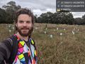
At the hash @-37.7092,145.0398
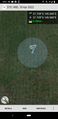
GPS


Achievements
John earned the Bicycle geohash achievement
|