Difference between revisions of "2022-04-24 -37 144"
(An expedition message sent via Geohash Droid for Android.) |
Felix Dance (talk | contribs) (Added achivement) |
||
| (5 intermediate revisions by 2 users not shown) | |||
| Line 1: | Line 1: | ||
| − | + | {{meetup graticule | |
| − | |||
| − | |||
| − | |||
| − | |||
| − | |||
| − | |||
| − | |||
| − | |||
| lat=-37 | | lat=-37 | ||
| lon=144 | | lon=144 | ||
| date=2022-04-24 | | date=2022-04-24 | ||
| − | }} | + | }} |
__NOTOC__ | __NOTOC__ | ||
== Location == | == Location == | ||
| − | + | On a street in Wyndham Vale | |
== Participants == | == Participants == | ||
| − | + | [[User:Johnwrw|John]] | |
| − | + | ||
| + | == Expedition == | ||
| + | A nice straightforward one. On a street less than a kay from Wyndham Vale station, which itself is only 25mins from Footscray station by train. | ||
| − | + | I had neither the time nor the inclination to ride the whole way out there, feeling the effects of having attended a big 30th birthday the night before, but I still wanted to knock this one off, so I enlisted the services of the rail network. | |
| − | |||
| − | + | I checked the train timetable a bit after 4 and saw that if I caught the 4:38 from Footscray, I would leave a perfect 18 minute window in which to visit the hash between arriving at Wyndham Vale and the next train leaving back to Footscray. All in all I should be home in under 90mins. Given the trains were a whole 40mins apart this could have been far less convenient. | |
| − | + | ||
| + | It all went to plan, I headed off on my bike towards the station at 4:31, caught my train and arrived on time at 5:03. As I rolled towards the hash I wondered if there was something I could do more exciting than just reach the point. Since it seemed to be on the road itself I contemplated the speedracer achievement. | ||
| + | |||
| + | I got to the street itself, quiet and residential, and there was no speed limit advertised, so I assumed the limit was 50kph. I found the hash itself, as expected, right in the middle of the road. | ||
| + | |||
| + | I had no easy way of monitoring my speed, so I just decided to record a little section on Strava having a couple of passes at it as fast as I could manage, then see what it could tell me afterwards. I thought 50kph was likely going to be tough to reach though. | ||
| + | |||
| + | My first attempt I had the benefit of a slight downhill, but I didn't manage to get up into an ideal gear. On the way back I got the gearing better, but now I was battling the slight slope. According to Strava for both of them I peaked at a bit over 40kph, so the speedracer achievement will have to wait for another day, because by this time I needed to head back towards to station and not do any more faffing about. | ||
| − | + | I caught my train back, fairly full with Richmond supporters heading in to the game against Melbourne, and got back smoothly, arriving home at 5:56, an 85min trip in total | |
| − | |||
== Photos == | == Photos == | ||
| − | + | ||
| − | |||
| − | |||
<gallery perrow="5"> | <gallery perrow="5"> | ||
| + | |||
| + | Image:2022-04-24_-37_144_Johnwrw_1650785337650.jpg|Hello! [https://openstreetmap.org/?mlat=-37.88016111&mlon=144.60944722&zoom=16 @-37.8802,144.6094] | ||
| + | |||
| + | Image:2022-04-24_-37_144_Johnwrw_1650785486701.jpg|Gps | ||
</gallery> | </gallery> | ||
== Achievements == | == Achievements == | ||
| − | {{ | + | {{bicycle geohash |
| − | |||
| − | + | | latitude = -37 | |
| − | + | | longitude = 144 | |
| − | [[ | + | | date = 2022-04-24 |
| + | | name = [[User:Johnwrw|Johnwrw]] | ||
| + | | distance = 36 kms | ||
| + | | bothways = true | ||
| + | | image = 2022-04-24_-37_144_Johnwrw_1650785337650.jpg | ||
| + | }} | ||
| − | + | [[Category:Expeditions]] | |
| − | |||
| − | |||
| − | |||
| − | |||
| − | |||
| − | |||
| − | |||
| − | |||
| − | |||
| − | |||
[[Category:Expeditions with photos]] | [[Category:Expeditions with photos]] | ||
| − | + | ||
| − | |||
| − | |||
| − | |||
| − | |||
[[Category:Coordinates reached]] | [[Category:Coordinates reached]] | ||
| − | + | {{location|AU|VIC|WY}} | |
| − | |||
| − | |||
| − | |||
| − | |||
| − | |||
| − | |||
| − | |||
| − | |||
| − | |||
| − | |||
| − | |||
| − | |||
| − | |||
| − | |||
| − | |||
| − | |||
| − | |||
Latest revision as of 00:43, 14 June 2023
| Sun 24 Apr 2022 in -37,144: -37.8801597, 144.6094685 geohashing.info google osm bing/os kml crox |
Location
On a street in Wyndham Vale
Participants
Expedition
A nice straightforward one. On a street less than a kay from Wyndham Vale station, which itself is only 25mins from Footscray station by train.
I had neither the time nor the inclination to ride the whole way out there, feeling the effects of having attended a big 30th birthday the night before, but I still wanted to knock this one off, so I enlisted the services of the rail network.
I checked the train timetable a bit after 4 and saw that if I caught the 4:38 from Footscray, I would leave a perfect 18 minute window in which to visit the hash between arriving at Wyndham Vale and the next train leaving back to Footscray. All in all I should be home in under 90mins. Given the trains were a whole 40mins apart this could have been far less convenient.
It all went to plan, I headed off on my bike towards the station at 4:31, caught my train and arrived on time at 5:03. As I rolled towards the hash I wondered if there was something I could do more exciting than just reach the point. Since it seemed to be on the road itself I contemplated the speedracer achievement.
I got to the street itself, quiet and residential, and there was no speed limit advertised, so I assumed the limit was 50kph. I found the hash itself, as expected, right in the middle of the road.
I had no easy way of monitoring my speed, so I just decided to record a little section on Strava having a couple of passes at it as fast as I could manage, then see what it could tell me afterwards. I thought 50kph was likely going to be tough to reach though.
My first attempt I had the benefit of a slight downhill, but I didn't manage to get up into an ideal gear. On the way back I got the gearing better, but now I was battling the slight slope. According to Strava for both of them I peaked at a bit over 40kph, so the speedracer achievement will have to wait for another day, because by this time I needed to head back towards to station and not do any more faffing about.
I caught my train back, fairly full with Richmond supporters heading in to the game against Melbourne, and got back smoothly, arriving home at 5:56, an 85min trip in total
Photos
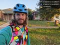
Hello! @-37.8802,144.6094
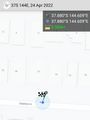
Gps


Achievements
Johnwrw earned the Bicycle geohash achievement
|