Difference between revisions of "2022-06-01 33 -111"
(trying first expiditon) |
m (per Renaming Proposal) |
||
| (7 intermediate revisions by 3 users not shown) | |||
| Line 15: | Line 15: | ||
== Location == | == Location == | ||
33.260850, -111.818460 | 33.260850, -111.818460 | ||
| + | |||
| + | Next to an Amazon warehouse in undeveloped lands. Being only 3km away, not close enough for a near couch-potato, but still impressive. | ||
== Participants == | == Participants == | ||
| − | [[User:BinaryOrbitals|BinaryOrbitals]] | + | [[User:BinaryOrbitals|BinaryOrbitals]] |
== Plans == | == Plans == | ||
| − | + | Later this day, I'll drive over to the location which is near a [https://www.google.com/maps/place/33%C2%B015'39.1%22N+111%C2%B049'06.5%22W/@33.26089,-111.8200581,686 Circle K & Amazon Warehouse] | |
| + | Despite the 100F/38C high today I'll probably need some thicker clothing to get through the plant material. There's a fence on the sides near the street so I will have to go from Airport Blvd. rather than the main roads. | ||
| − | == | + | == Expedition == |
| − | + | At ~2:40 pm I went to the location to try to reach it from the nearest public road (after picking up a GeoSquishy (TM) from the local vendor). I followed a dirt path a some dozen meters before it abruptly stopped. Unfortunately, since the last time google maps updated the satellite imagery some months ago, the plant life had grown so much that the location had become inaccessible, less than 200 metres from where I stood, now defeated. | |
| − | + | {{done with nature | |
| − | |||
| − | == | + | | latitude = 33 |
| − | + | | longitude = -111 | |
| + | | date = 2022-06-01 | ||
| + | | excuse = Outdated Satellite Imagery | ||
| + | | name = BinaryOrbitals | ||
| + | }} | ||
== Photos == | == Photos == | ||
| Line 36: | Line 42: | ||
--> | --> | ||
<gallery perrow="5"> | <gallery perrow="5"> | ||
| + | File:2022-06-01 33 -111 Geosquishy.jpg | Well Earned @ 33.2616425,-111.8231399 A mere 450 meters from the geohash | ||
| + | File:2022-06-01 33 -111 Nearest Approach.jpg | Outdated Satellite Photography strikes again | ||
| + | File:2022-06-01 33 -111 Thickwildlife.jpg | Mother Nature's natural barrier to geohashing | ||
</gallery> | </gallery> | ||
| − | |||
| − | |||
| − | |||
| − | |||
| − | |||
| − | |||
| − | |||
| − | |||
| − | |||
| − | |||
| − | |||
| − | |||
| − | |||
| − | |||
| − | |||
| − | |||
| − | |||
| − | |||
[[Category:Expeditions]] | [[Category:Expeditions]] | ||
| − | |||
[[Category:Expeditions with photos]] | [[Category:Expeditions with photos]] | ||
| − | |||
| − | |||
| − | |||
| − | |||
| − | |||
| − | |||
| − | |||
| − | |||
| − | |||
[[Category:Coordinates not reached]] | [[Category:Coordinates not reached]] | ||
| − | |||
| − | |||
[[Category:Not reached - Mother Nature]] | [[Category:Not reached - Mother Nature]] | ||
| − | + | {{location|US|AZ|MA}} | |
| − | |||
| − | |||
| − | |||
| − | |||
| − | |||
| − | |||
| − | |||
| − | |||
| − | |||
| − | |||
Latest revision as of 14:26, 2 April 2024
| Wed 1 Jun 2022 in 33,-111: 33.2608541, -111.8184593 geohashing.info google osm bing/os kml crox |
Location
33.260850, -111.818460
Next to an Amazon warehouse in undeveloped lands. Being only 3km away, not close enough for a near couch-potato, but still impressive.
Participants
Plans
Later this day, I'll drive over to the location which is near a Circle K & Amazon Warehouse Despite the 100F/38C high today I'll probably need some thicker clothing to get through the plant material. There's a fence on the sides near the street so I will have to go from Airport Blvd. rather than the main roads.
Expedition
At ~2:40 pm I went to the location to try to reach it from the nearest public road (after picking up a GeoSquishy (TM) from the local vendor). I followed a dirt path a some dozen meters before it abruptly stopped. Unfortunately, since the last time google maps updated the satellite imagery some months ago, the plant life had grown so much that the location had become inaccessible, less than 200 metres from where I stood, now defeated.
BinaryOrbitals earned the Done with Nature consolation prize
|
Photos
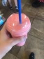
Well Earned @ 33.2616425,-111.8231399 A mere 450 meters from the geohash
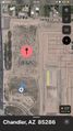
Outdated Satellite Photography strikes again
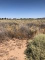
Mother Nature's natural barrier to geohashing


