Difference between revisions of "2022-08-07 50 7"
(→Participants) |
m (→Achievements: Fix tracklog and distance) |
||
| (9 intermediate revisions by 3 users not shown) | |||
| Line 20: | Line 20: | ||
== Plans == | == Plans == | ||
| − | + | Go jogging through the [https://de.wikipedia.org/wiki/Me%C3%9Fdorfer_Feld#/media/Datei:August_Macke_014.jpg Messdorfer Feld] to the hash location and then continue to the Rhine, since I wanted to do a long run today anyway. | |
== Expedition == | == Expedition == | ||
| − | + | Went according to plan, luckily the hash was not only close but due to being on the sidewalk next to a large street really accessible. Running was nice, a bit more urban than usually, but also I discovered some nice new places and then continue to the Rhine river and ran along it. | |
== Tracklog == | == Tracklog == | ||
| − | + | ||
| + | (Somehow, the [[Template:Tracklog]] seems not to be working for me, hopefully not because I accidentally named the gpx file with a .gpx.gpx extension when uploading. Anyway, the gpx file can be downloaded here: | ||
| + | [[File:2022-08-07_50-7_elimik31.gpx.gpx]].) | ||
| + | |||
| + | {{tracklog | 2022-08-07_50-7_elimik31.gpx.gpx }} | ||
== Photos == | == Photos == | ||
| Line 39: | Line 43: | ||
== Achievements == | == Achievements == | ||
{{#vardefine:ribbonwidth|100%}} | {{#vardefine:ribbonwidth|100%}} | ||
| − | |||
| − | |||
| − | |||
| − | |||
| − | |||
| − | |||
| − | |||
| − | + | {{Walk geohash | |
| − | + | | latitude = 50 | |
| − | + | | longitude = 7 | |
| − | -- | + | | date = 2022-08-07 |
| + | | name = Elimik31 | ||
| + | | distance = 15 km | ||
| + | | image = 2022-08-07_50_7_meliache_1659880380880.jpg | ||
| + | }} | ||
| + | {{Tron | ||
| + | | latitude = 50 | ||
| + | | longitude = 7 | ||
| + | | date = 2022-08-07 | ||
| + | | name = Elimik31 | ||
| + | | possessive = his | ||
| + | | tracklog = https://geohashing.site/geohashing/File:2022-08-07_50-7_elimik31.gpx.gpx | ||
| + | }} | ||
| − | |||
| − | |||
| − | |||
[[Category:Expeditions]] | [[Category:Expeditions]] | ||
| − | |||
[[Category:Expeditions with photos]] | [[Category:Expeditions with photos]] | ||
| − | |||
| − | |||
| − | |||
| − | |||
| − | |||
[[Category:Coordinates reached]] | [[Category:Coordinates reached]] | ||
| − | + | {{location|DE|NW|BN}} | |
| − | |||
| − | |||
| − | |||
| − | |||
| − | |||
| − | |||
| − | |||
| − | |||
| − | |||
| − | |||
| − | |||
| − | |||
| − | |||
| − | |||
| − | |||
| − | |||
| − | |||
Latest revision as of 09:44, 8 August 2022
| Sun 7 Aug 2022 in 50,7: 50.7448060, 7.0515324 geohashing.info google osm bing/os kml crox |
Location
In Bonn, Tannenbusch, right on a large road which I know, not far from me, which is why I got a notification about the hash.
Participants
Plans
Go jogging through the Messdorfer Feld to the hash location and then continue to the Rhine, since I wanted to do a long run today anyway.
Expedition
Went according to plan, luckily the hash was not only close but due to being on the sidewalk next to a large street really accessible. Running was nice, a bit more urban than usually, but also I discovered some nice new places and then continue to the Rhine river and ran along it.
Tracklog
(Somehow, the Template:Tracklog seems not to be working for me, hopefully not because I accidentally named the gpx file with a .gpx.gpx extension when uploading. Anyway, the gpx file can be downloaded here: File:2022-08-07 50-7 elimik31.gpx.gpx.)
Photos
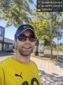
Jogged past the hashpoint which was close to home. @50.7448,7.0515

Achievements
Elimik31 earned the Walk geohash Achievement
|
Elimik31 earned the Tron achievement
|