Difference between revisions of "2022-10-20 36 -115"
(Created page with "<!-- If you did not specify these parameters in the template, please substitute appropriate values for IMAGE, LAT, LON, and DATE (YYYY-MM-DD format) Image:{{{image|IMAGE}}...") |
m (subst-ing) |
||
| (2 intermediate revisions by 2 users not shown) | |||
| Line 8: | Line 8: | ||
And DON'T FORGET to add your expedition and the best photo you took to the gallery on the Main Page! We'd love to read your report, but that means we first have to discover it! :) | And DON'T FORGET to add your expedition and the best photo you took to the gallery on the Main Page! We'd love to read your report, but that means we first have to discover it! :) | ||
-->{{meetup graticule | -->{{meetup graticule | ||
| − | | lat= | + | | lat=36 |
| − | | lon= | + | | lon=-115 |
| − | | date= | + | | date=2022-10-20 |
}}<!-- edit as necessary --> | }}<!-- edit as necessary --> | ||
== Location == | == Location == | ||
| Line 34: | Line 34: | ||
--> | --> | ||
<gallery perrow="5"> | <gallery perrow="5"> | ||
| + | |||
| + | Image:2022-10-20 36 -115.jpg|The end of the line for me. The hash point is about 5 miles ahead. | ||
</gallery> | </gallery> | ||
| − | |||
== Achievements == | == Achievements == | ||
| Line 44: | Line 45: | ||
__NOTOC__ | __NOTOC__ | ||
[[Category:Expeditions]] | [[Category:Expeditions]] | ||
| − | + | [[Category:Expeditions with photos]] | |
[[Category:Coordinates not reached]] | [[Category:Coordinates not reached]] | ||
| − | + | [[Category:Not reached - Time constraints]]<!--Assuming that the problem with the 5 miles was not the nature but the time it would take to walk them.--> | |
{{location|US|NV|CL}} | {{location|US|NV|CL}} | ||
Latest revision as of 20:52, 24 May 2024
| Thu 20 Oct 2022 in 36,-115: 36.0657423, -115.6488946 geohashing.info google osm bing/os kml crox |
Location
Just outside the Spring Mountains National Recreational Area, Clark County, Nevada
Participants
Expedition
This being my first expedition, I figured I would just get as close as I could to the point and then leave once I took a picture. Since this point was in the middle of the desert, I wasn't expecting much. Google Maps briefly lost the GPS signal as I left the Las Vegas city limits, but got it back when I needed to make a crucial turn (which was great as I don't think I would have noticed the road without it). Once I got on the Pahrump Valley Highway, it was smooth sailing from there (although I did get increasingly worried the farther out I drove).
Quite a few minutes later, Google Maps told me to make a right turn onto a road that would get me within walking distance of the point. The problem was, I missed it. I had to make a U-turn further down the highway, pass that road from the other direction, and then make another U-turn further down that way. Once I got back to where I was told the road was (and parked on the shoulder this time), I realized why I didn't notice it the first time: it barely resembled an actual road from the highway.
The road I was supposed to take looked more like a trail, and I didn't feel comfortable driving on it, nor did I really want to walk the remaining 5 miles. I decided to take a picture of the makeshift entrance to the road and get on my way back home, briefly stopping at a gas station in Blue Diamond (just in case I couldn't reach one in Enterprise). Once I got home, I found out that OSM only shows the road going out as far as I got. Go figure! Regardless, I still had fun getting there, and it was still a great experience as a novice geohasher.
Photos
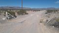
The end of the line for me. The hash point is about 5 miles ahead.
