Difference between revisions of "2023-02-24 -37 145"
(→Achievements) |
Felix Dance (talk | contribs) |
||
| (One intermediate revision by the same user not shown) | |||
| Line 1: | Line 1: | ||
| + | [[Image:{{{image|Geohash 2023-02-24 -37 145 01 Hash.jpg}}}|thumb|left]] | ||
| + | |||
{{meetup graticule|date=2023-02-24|lat=-37|lon=145}} | {{meetup graticule|date=2023-02-24|lat=-37|lon=145}} | ||
| + | |||
==Location== | ==Location== | ||
On a road near a big quarry in Wollert. | On a road near a big quarry in Wollert. | ||
| Line 24: | Line 27: | ||
Image:2023-02-24_-37_145_Johnwrw_1677582433640.jpg|Long grass | Image:2023-02-24_-37_145_Johnwrw_1677582433640.jpg|Long grass | ||
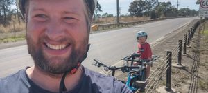
| + | Image:Geohash 2023-02-24 -37 145 01 Hash.jpg|Tom at the hash | ||
</gallery> | </gallery> | ||
Latest revision as of 22:48, 7 March 2023
| Fri 24 Feb 2023 in -37,145: -37.5948580, 145.0426858 geohashing.info google osm bing/os kml crox |
Location
On a road near a big quarry in Wollert.
Participants
Expedition 1 (Tom and Max)
Continuing a recent streak of successful hashes in Victoria, and particularly inspired by an effort of Stevage at the start of the streak, I headed off on the train from Heidelberg station with my four year old son Max and our cargo bike. The trip to Epping station was fairly uneventful, though we did take a bike short cut from Westgarth to Merri station. At Epping station we were met with a strong northerly head wind. We took the Darebin Creek and Findons Creek West Branch bike paths to Bindts Rd. The paths were suprisingly pleasant, meandering through modern housing estates and following the picturesque creeks. At Bindts Rd we found several road closures that were not marked on Google maps, but fortunately they did not take much effort to bypass. Bindts Rd quickly became unsealed and corrugated as we left the last of the housing estates. Bridge Inn road was busy with trucks from a nearby quarry and tip, so I sprinted the final 400m to the hash point at the side of the road in gaps in the traffic. Fortunately there was just enough shoulder on the road to stay safe, but the traffic made it very unpleasant so we quickly took a photo snap and headed back to Bindts Rd. The wind made the return trip very enjoyable!
Expedition 2 (John)
Even though Tom and Max had already maintained the group streak for the day, I wanted to get a three day personal streak. So after a little bit of work at uni in the morning, I headed north around lunchtime. I went up the Upfield bike path, then the Merri creek, then the Darebin creek. It was rather hot, and gaining elevation into a northerly headwind wasn't ideal for speedy progress or comfort but I got there.
After dealing with similar road closures and suboptimal road conditions mentioned in the above section, I too reached the point, and made a record of it. I then decided to continue on to Mernda for a train home, making use of the westerly component off the aforementioned northerly being to my back. I was rather aggrieved to be stopped by lights a couple of times right when I was building up a good head of steam. But I still got to the station swiftly and, after fighting through a throng of school kids getting off the train, I got on the train back. I got off at Rushall and rode home across the inner circle path and then across royal park.
Photos
Achievements
Thomasha earned the Public transport geohash achievement
|
John earned the Bicycle geohash achievement
|


