Difference between revisions of "2023-03-07 47 8"
Globescorer (talk | contribs) |
m (Categories) |
||
| (4 intermediate revisions by one other user not shown) | |||
| Line 3: | Line 3: | ||
== Location == | == Location == | ||
The hashpoint is located in a field near the very small village Gündelhart TG (Switzerland) | The hashpoint is located in a field near the very small village Gündelhart TG (Switzerland) | ||
| − | [[ | + | |
| + | [[File:2023-03-07 47 8 Gündelhart.jpg|500px]] | ||
== Participants == | == Participants == | ||
| Line 12: | Line 13: | ||
==Expedition== | ==Expedition== | ||
| + | It actually happened that i took my motorcycle out of the garage for the first time this year in the afternoon and got ready for a ride. I abandoned my plan to take different routes there and back when I got off the bike and hiked towards Geohash. So: the expedition was successful, but the TRON-plan failed...<p></p> | ||
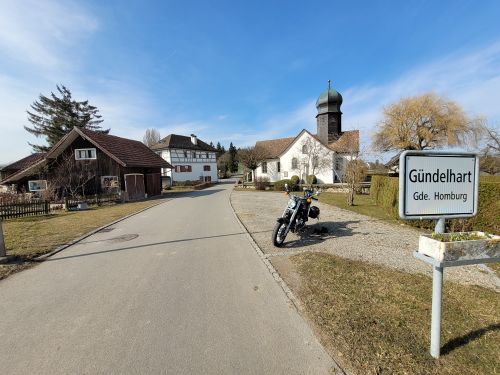
| + | I parked my motorcycle at the church in Gündelhart and continued on foot to Geohash. Once again the field was filled with liquid manure... after more than a month without precipitation it is supposed to start raining soon. After I took the photos, I went on to the former castle Gündelhart which is today a farm estate. A very beautiful and well-kept property.<p></p> | ||
| + | After this visit I had to return to my bike and to drive back home. | ||
==Gallery== | ==Gallery== | ||
| Line 22: | Line 26: | ||
File:2023-03-07 47 8 north.jpg |north | File:2023-03-07 47 8 north.jpg |north | ||
File:2023-03-07 47 8 east.jpg |east | File:2023-03-07 47 8 east.jpg |east | ||
| + | File:2023-03-07 47 8 proof 1.jpg |Proof 1 | ||
| + | File:2023-03-07 47 8 proof 2.jpg |Proof 2 | ||
File:2023-03-07 47 8 The Hasher.jpg |Me | File:2023-03-07 47 8 The Hasher.jpg |Me | ||
File:2023-03-07 47 8 castle 1.jpg |The castle south | File:2023-03-07 47 8 castle 1.jpg |The castle south | ||
| Line 27: | Line 33: | ||
</gallery> | </gallery> | ||
| − | + | [[Category:Expeditions]] | |
| − | [[Category: | + | [[Category:Expeditions with photos]] |
| + | [[Category:Coordinates reached]] | ||
{{location|CH|TG}} | {{location|CH|TG}} | ||
Latest revision as of 21:31, 7 March 2023
| Tue 7 Mar 2023 in 47,8: 47.6335445, 8.9437915 geohashing.info google osm bing/os kml crox |
Contents
Location
The hashpoint is located in a field near the very small village Gündelhart TG (Switzerland)
Participants
Plans
After Lunch in my free afternoon I will drive to Gündelhart and back as a tron. For this I take my Motorcycle the first time this year for a ride (like a TRON :-) I will be there at about 2 o'clock in the afternoon. And I will visit there the former castle Gündelhart which is today a farm estate and also the nearby church.
Expedition
It actually happened that i took my motorcycle out of the garage for the first time this year in the afternoon and got ready for a ride. I abandoned my plan to take different routes there and back when I got off the bike and hiked towards Geohash. So: the expedition was successful, but the TRON-plan failed...
I parked my motorcycle at the church in Gündelhart and continued on foot to Geohash. Once again the field was filled with liquid manure... after more than a month without precipitation it is supposed to start raining soon. After I took the photos, I went on to the former castle Gündelhart which is today a farm estate. A very beautiful and well-kept property.
After this visit I had to return to my bike and to drive back home.


