Difference between revisions of "2023-08-11 47 8"
Globescorer (talk | contribs) (→Photos) |
Globescorer (talk | contribs) (→Expedition) |
||
| (6 intermediate revisions by 3 users not shown) | |||
| Line 1: | Line 1: | ||
| − | {{meetup graticule|date=2023-08- | + | {{meetup graticule|date=2023-08-11|lat=47|lon=8}} |
[[File:2023-08-11 47 8 parking.jpg|600px]] | [[File:2023-08-11 47 8 parking.jpg|600px]] | ||
== Location == | == Location == | ||
| Line 11: | Line 11: | ||
== Expedition == | == Expedition == | ||
| − | + | So i drove towards this geohash before work. The coordinates are about 25 meters from the German-Swiss border. So I earned the border-achievement, even though I can't provide any proof because I couldn't see any sign out in the middle of nowhere. Just the town sign of Buchenloo in Switzerland and that the coordinates are in Germany. So I must have walked across the border... :-) The unpaved road on which I then parked the motorcycle is also called "Zollstrasse". (= customs road) | |
| + | |||
| + | A few pigs wallowed next to it in the morning sun. From there I walked the last few meters to the point and documented everything. Now I drove a different route to the office. And from there back home in the evening. Actually, I wanted to do the whole track as a Tron track. The bike did it all without having to ride a piece twice, however the few meters of walking from the bike to the geohash and back was the same path... Does this apply to the Tron achievement now? I don't know it. | ||
== Photos == | == Photos == | ||
| Line 30: | Line 32: | ||
</gallery> | </gallery> | ||
[[File:2023-08-11 47 8 Border.JPG|1000px]] | [[File:2023-08-11 47 8 Border.JPG|1000px]] | ||
| + | |||
| + | ==Ribbons== | ||
| + | {{Border geohash achievement | latitude = 47 | longitude = 8 | date = 2023-08-11 | country1= Switzerland | country2= Germany | name = globescorer }} | ||
| + | {{consecutive geohash 2 | count = 2 | latitude = 47 | longitude = 8 | date = 2023-08-10 | name = globescorer }} | ||
| + | {{land geohash|date=2023-08-11|latitude=47|longitude=8|name=[[User:globescorer|globescorer]]|image=2023-08-11 47 8 The Geohash.jpg}} | ||
| + | |||
| + | [[Category:Expeditions]] | ||
| + | [[Category:Expeditions with photos]] | ||
| + | [[Category:Coordinates reached]] | ||
| + | {{location|DE|BW|WT}} | ||
Latest revision as of 13:21, 11 August 2023
| Fri 11 Aug 2023 in 47,8: 47.6150248, 8.4820363 geohashing.info google osm bing/os kml crox |
Location
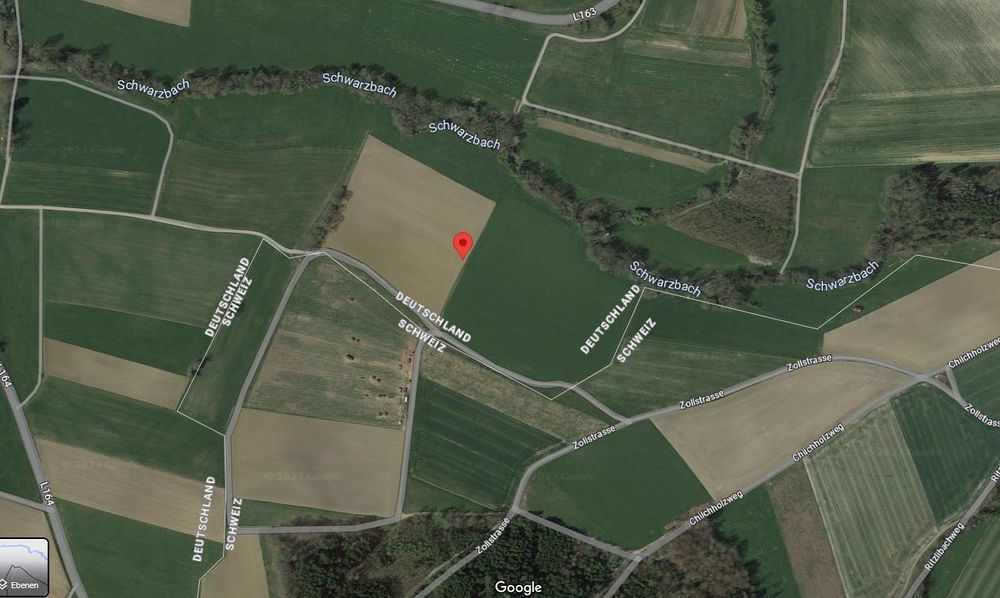
Located at the edge of a field between Bühl, Germany and Buchenloo, Switzerland
Participants
Plans
In this morning before work I wanted to visit this Hashpoint by motorcycle.
Expedition
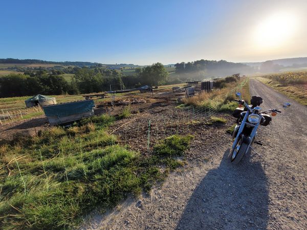
So i drove towards this geohash before work. The coordinates are about 25 meters from the German-Swiss border. So I earned the border-achievement, even though I can't provide any proof because I couldn't see any sign out in the middle of nowhere. Just the town sign of Buchenloo in Switzerland and that the coordinates are in Germany. So I must have walked across the border... :-) The unpaved road on which I then parked the motorcycle is also called "Zollstrasse". (= customs road)
A few pigs wallowed next to it in the morning sun. From there I walked the last few meters to the point and documented everything. Now I drove a different route to the office. And from there back home in the evening. Actually, I wanted to do the whole track as a Tron track. The bike did it all without having to ride a piece twice, however the few meters of walking from the bike to the geohash and back was the same path... Does this apply to the Tron achievement now? I don't know it.
Photos
Ribbons
globescorer earned the Border geohash achievement
|
globescorer earned the Consecutive geohash achievement
|
globescorer earned the Land geohash achievement
|


