Difference between revisions of "2023-10-13 39 -111"
From Geohashing
m (Location) |
m (subst-ing) |
||
| (One intermediate revision by one other user not shown) | |||
| Line 1: | Line 1: | ||
{{meetup graticule | {{meetup graticule | ||
| − | | lat= | + | | lat=39 |
| − | | lon= | + | | lon=-111 |
| − | | date= | + | | date=2023-10-13 |
}}<!-- edit as necessary --> | }}<!-- edit as necessary --> | ||
== Location == | == Location == | ||
| Line 23: | Line 23: | ||
[[Category:Expeditions]] | [[Category:Expeditions]] | ||
[[Category:Expeditions with photos]] | [[Category:Expeditions with photos]] | ||
| + | [[Category:Coordinates not reached]] | ||
[[Category:Not reached - No public access]] | [[Category:Not reached - No public access]] | ||
{{location|US|UT|EM}} | {{location|US|UT|EM}} | ||
Latest revision as of 21:08, 24 May 2024
| Fri 13 Oct 2023 in 39,-111: 39.1729592, -111.0440966 geohashing.info google osm bing/os kml crox |
Location
At the entrance to the Hunter Power Plant south of Castle Dale.
Participants
Expedition
This looked like an extremely easy hashpoint, just off the shoulder of a road a few hundred meters from a freeway exit. Unfortunately for me, it turns out that "Coal Haul Road" is only for, well, hauling coal. A steady procession of trucks come through to feed the power plant, which generates electricity. Access is closed to everybody else, so I was thwarted 140 meters out.
Photos
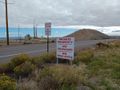
Thwarted.
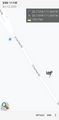
Evidence of absence.

