Difference between revisions of "2023-10-13 40 -111"
From Geohashing
m |
m (subst-ing) |
||
| (One intermediate revision by one other user not shown) | |||
| Line 8: | Line 8: | ||
And DON'T FORGET to add your expedition and the best photo you took to the gallery on the Main Page! We'd love to read your report, but that means we first have to discover it! :) | And DON'T FORGET to add your expedition and the best photo you took to the gallery on the Main Page! We'd love to read your report, but that means we first have to discover it! :) | ||
-->{{meetup graticule | -->{{meetup graticule | ||
| − | | lat= | + | | lat=40 |
| − | | lon= | + | | lon=-111 |
| − | | date= | + | | date=2023-10-13 |
}}<!-- edit as necessary --> | }}<!-- edit as necessary --> | ||
== Location == | == Location == | ||
| Line 25: | Line 25: | ||
== Photos == | == Photos == | ||
<gallery perrow="5"> | <gallery perrow="5"> | ||
| − | File:2023-10-13 40 -111 a.jpg| | + | File:2023-10-13 40 -111 a.jpg|Thwarted! |
File:2023-10-13 40 -111 b.jpg|Phooey. | File:2023-10-13 40 -111 b.jpg|Phooey. | ||
</gallery> | </gallery> | ||
Latest revision as of 21:08, 24 May 2024
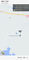
| Fri 13 Oct 2023 in 40,-111: 40.1729592, -111.0440966 geohashing.info google osm bing/os kml crox |
Location
In a residential development by Soldier Creek Bay.
Participants
Expedition
From the debacle at 2023-10-13 39 -111, I proceeded northeast and then back west to the debacle at 2023-10-13 40 -111. This hashpoint is in somebody's driveway in a development of houses overlooking a reservoir; since there's no town nearby, they are probably either vacation homes or for retirees.
Unfortunately, the area is gated, so I was thwarted 195 meters out. Phooey.
Photos
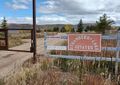
Thwarted!
Phooey.

