Difference between revisions of "2024-03-21 34 -118"
From Geohashing
(→Location: Added description) |
m (Location) |
||
| (6 intermediate revisions by 2 users not shown) | |||
| Line 19: | Line 19: | ||
<!-- who attended: If you link to your wiki user name in this section, your expedition will be picked up by the various statistics generated for geohashing. You may use three tildes ~ as a shortcut to automatically insert the user signature of the account you are editing with. | <!-- who attended: If you link to your wiki user name in this section, your expedition will be picked up by the various statistics generated for geohashing. You may use three tildes ~ as a shortcut to automatically insert the user signature of the account you are editing with. | ||
--> | --> | ||
| − | + | [[User:Bravissimo594|Bravissimo594]] ([[User talk:Bravissimo594|talk]]) | |
| − | |||
| − | |||
== Expedition == | == Expedition == | ||
| Line 28: | Line 26: | ||
*No luck. I left a poster on the front porch. -- [[User:Bravissimo594|Bravissimo594]] ([[User talk:Bravissimo594|talk]]) [https://openstreetmap.org/?mlat=34.13366540&mlon=-118.09757390&zoom=16 @34.1337,-118.0976] 16:16, 21 March 2024 (PDT) | *No luck. I left a poster on the front porch. -- [[User:Bravissimo594|Bravissimo594]] ([[User talk:Bravissimo594|talk]]) [https://openstreetmap.org/?mlat=34.13366540&mlon=-118.09757390&zoom=16 @34.1337,-118.0976] 16:16, 21 March 2024 (PDT) | ||
| − | |||
| − | |||
| − | |||
== Photos == | == Photos == | ||
<!-- Insert pictures between the gallery tags using the following format: | <!-- Insert pictures between the gallery tags using the following format: | ||
| Line 45: | Line 40: | ||
__NOTOC__ | __NOTOC__ | ||
| − | |||
| − | |||
| − | |||
| − | |||
| − | |||
| − | |||
| − | |||
| − | |||
| − | |||
| − | |||
| − | |||
| − | |||
| − | |||
| − | |||
[[Category:Expeditions]] | [[Category:Expeditions]] | ||
| − | |||
[[Category:Expeditions with photos]] | [[Category:Expeditions with photos]] | ||
| − | |||
| − | |||
| − | |||
| − | |||
| − | |||
| − | |||
| − | |||
| − | |||
| − | |||
[[Category:Coordinates not reached]] | [[Category:Coordinates not reached]] | ||
| − | |||
| − | |||
| − | |||
| − | |||
| − | |||
[[Category:Not reached - No public access]] | [[Category:Not reached - No public access]] | ||
| − | + | {{location|US|CA|LO}} | |
| − | |||
| − | |||
| − | |||
| − | |||
| − | |||
| − | |||
| − | |||
Latest revision as of 03:42, 30 March 2024
| Thu 21 Mar 2024 in 34,-118: 34.1340350, -118.0975891 geohashing.info google osm bing/os kml crox |
Location
On the property of a private residence in the northeastern corner of San Marino, CA
Participants
Expedition
- No luck. I left a poster on the front porch. -- Bravissimo594 (talk) @34.1337,-118.0976 16:16, 21 March 2024 (PDT)
Photos
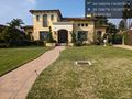
Hash point is somewhere within this house or possibly in its backyard @34.1337,-118.0976
