Difference between revisions of "2024-04-24 47 8"
From Geohashing
Globescorer (talk | contribs) (→Expedition) |
Globescorer (talk | contribs) (→Achievements) |
||
| (4 intermediate revisions by 2 users not shown) | |||
| Line 12: | Line 12: | ||
==Expedition== | ==Expedition== | ||
Nothing special. Lunchtime. | Nothing special. Lunchtime. | ||
| + | |||
I drove as close as possible to the coordinates. | I drove as close as possible to the coordinates. | ||
| + | |||
Then short walk to the Point -> Panorama + Proof | Then short walk to the Point -> Panorama + Proof | ||
| + | |||
View to the near village [https://de.wikipedia.org/wiki/Sch%C3%B6fflisdorf Schöfflisdorf] and another view in the other direction to [https://de.wikipedia.org/wiki/Regensberg Regensberg]. Regensberg is a really nice old little town on a hill with a castle... | View to the near village [https://de.wikipedia.org/wiki/Sch%C3%B6fflisdorf Schöfflisdorf] and another view in the other direction to [https://de.wikipedia.org/wiki/Regensberg Regensberg]. Regensberg is a really nice old little town on a hill with a castle... | ||
| + | |||
Went back to work... | Went back to work... | ||
| Line 23: | Line 27: | ||
File:2024-04-24 47 8 proof 1.jpg |The Proof | File:2024-04-24 47 8 proof 1.jpg |The Proof | ||
File:2024-04-24 47 8 Schöfflisdorf.jpg |view to Schöfflisdorf | File:2024-04-24 47 8 Schöfflisdorf.jpg |view to Schöfflisdorf | ||
| − | File:2024-04-24 47 8 Regensberg.jpg |view to Regensberg | + | File:2024-04-24 47 8 Regensberg.jpg |view to Regensberg (the one on top of the hill :-) |
File:2024-04-24 47 8 panorama.jpg |Panorama | File:2024-04-24 47 8 panorama.jpg |Panorama | ||
| Line 32: | Line 36: | ||
{{land geohash|date=2024-04-24|latitude=47|longitude=8|name=[[User:globescorer|globescorer]]|image=2024-04-24 47 8 Schöfflisdorf.jpg}} | {{land geohash|date=2024-04-24|latitude=47|longitude=8|name=[[User:globescorer|globescorer]]|image=2024-04-24 47 8 Schöfflisdorf.jpg}} | ||
{{consecutive geohash 2 | count = 2 | latitude = 47 | longitude = 8 | date = 2024-04-23 | name = globescorer }} | {{consecutive geohash 2 | count = 2 | latitude = 47 | longitude = 8 | date = 2024-04-23 | name = globescorer }} | ||
| + | {{Speedrun achievement | ||
| + | | latitude = 47 | ||
| + | | longitude = 8 | ||
| + | | date = 2024-04-24 | ||
| + | | minutes = 50 | ||
| + | | name = [[User:globescorer|globescorer]] | ||
| + | }} | ||
| − | + | __NOTOC__ | |
| + | [[Category:Expeditions]] | ||
| + | [[Category:Coordinates reached]] | ||
| + | [[Category:Expeditions with photos]] | ||
{{location|CH|ZH}} | {{location|CH|ZH}} | ||
Latest revision as of 07:58, 27 September 2024
| Wed 24 Apr 2024 in 47,8: 47.4960198, 8.4281382 geohashing.info google osm bing/os kml crox |
Location
This Geohash is located in a field or meadow near Schöfflisdorf (ZH).
Participants
Plans
going there in my lunchtime at approx. 12:30. I hope it's accessible...
Expedition
Nothing special. Lunchtime.
I drove as close as possible to the coordinates.
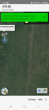
Then short walk to the Point -> Panorama + Proof
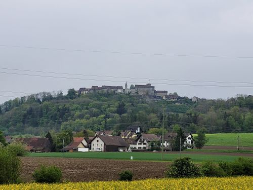
View to the near village Schöfflisdorf and another view in the other direction to Regensberg. Regensberg is a really nice old little town on a hill with a castle...
Went back to work...
Photos
Achievements
globescorer earned the Land geohash achievement
|
globescorer earned the Consecutive geohash achievement
|
globescorer earned the Speedrun achievement
|


