Difference between revisions of "2024-05-27 49 10"
([live picture]Proof) |
|||
| (5 intermediate revisions by 3 users not shown) | |||
| Line 1: | Line 1: | ||
| − | + | {{meetup graticule|date=2024-05-27|lat=49|lon=10}} | |
| + | == Location == | ||
| + | This Geohash is located in a forest near Laubendorf. | ||
| − | [[ | + | == Participants == |
| + | *[[User:Torodeas|Torodeas]] | ||
| − | + | == Expedition == | |
| − | + | Similar to some other expeditions, I always wanted to use the RB12 line, but I never had a reason to do so. | |
| + | This hash gives me a sufficient reason excuse, so I finally get to use it. | ||
| − | + | After work, I take the bus to Erlangen Central Station, to connect to the train south and finally to connect onto the RB12 towards Markt Erlbach in Fürth. I easily make all the connections and sit down in my train towards Laubendorf. | |
| − | |||
| − | |||
| − | |||
| − | + | For some reason, I am very exhausted and almost fall asleep during the RB12 train. I will have to use it again when I feel more energetic to be able to take in the route to its fullest. But I manage to depart the train in Laubendorf and start hunting for the hash. | |
| − | |||
| − | |||
| − | + | The hash is in a forest and very close to a path, so it's easy to reach. I record proof, take a few pictures, and then go home to rest. | |
| − | |||
| − | |||
| − | |||
| − | |||
== Tracklog == | == Tracklog == | ||
<!-- if your GPS device keeps a log, you may use Template:Tracklog, post a link here, or both --> | <!-- if your GPS device keeps a log, you may use Template:Tracklog, post a link here, or both --> | ||
| + | {{tracklog|Torodeas_20240527.gpx}} | ||
== Photos == | == Photos == | ||
| − | |||
| − | |||
| − | |||
<gallery perrow="5"> | <gallery perrow="5"> | ||
| − | |||
Image:2024-05-27_49_10_Torodeas_1716833847276.jpg|Laubendorf train station | Image:2024-05-27_49_10_Torodeas_1716833847276.jpg|Laubendorf train station | ||
| − | |||
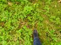
Image:2024-05-27_49_10_Torodeas_1716833847286.jpg|Proof | Image:2024-05-27_49_10_Torodeas_1716833847286.jpg|Proof | ||
| + | Image:2024-05-27_49_10_Torodeas_1716833847320.jpg|At the hash | ||
| + | Image:2024-05-27_49_10_Torodeas_1716833847349.jpg|View from hash | ||
</gallery> | </gallery> | ||
| Line 38: | Line 31: | ||
{{#vardefine:ribbonwidth|100%}} | {{#vardefine:ribbonwidth|100%}} | ||
<!-- Add any achievement ribbons you earned below, or remove this section --> | <!-- Add any achievement ribbons you earned below, or remove this section --> | ||
| + | {{land geohash | ||
| + | | date = 2024-05-27 | ||
| + | | latitude = 49 | ||
| + | | longitude = 10 | ||
| + | | name = Torodeas | ||
| + | }} | ||
| + | |||
| + | {{Public transport geohash | ||
| + | | date = 2024-05-27 | ||
| + | | latitude = 49 | ||
| + | | longitude = 10 | ||
| + | | name = Torodeas | ||
| + | | busline = 30, RE14, RB12 | ||
| + | }} | ||
__NOTOC__ | __NOTOC__ | ||
| − | |||
| − | |||
| − | |||
| − | |||
| − | |||
| − | |||
| − | |||
| − | |||
| − | |||
| − | |||
[[Category:Expeditions]] | [[Category:Expeditions]] | ||
| − | |||
[[Category:Expeditions with photos]] | [[Category:Expeditions with photos]] | ||
| − | |||
| − | |||
| − | |||
| − | |||
[[Category:Coordinates reached]] | [[Category:Coordinates reached]] | ||
| − | + | {{location|DE|BY|FÜ}} | |
| − | |||
| − | |||
| − | |||
| − | |||
| − | |||
| − | |||
| − | |||
| − | |||
| − | |||
| − | |||
| − | |||
| − | |||
| − | |||
Latest revision as of 06:12, 18 August 2024
| Mon 27 May 2024 in 49,10: 49.5018873, 10.7247090 geohashing.info google osm bing/os kml crox |
Location
This Geohash is located in a forest near Laubendorf.
Participants
Expedition
Similar to some other expeditions, I always wanted to use the RB12 line, but I never had a reason to do so. This hash gives me a sufficient reason excuse, so I finally get to use it.
After work, I take the bus to Erlangen Central Station, to connect to the train south and finally to connect onto the RB12 towards Markt Erlbach in Fürth. I easily make all the connections and sit down in my train towards Laubendorf.
For some reason, I am very exhausted and almost fall asleep during the RB12 train. I will have to use it again when I feel more energetic to be able to take in the route to its fullest. But I manage to depart the train in Laubendorf and start hunting for the hash.
The hash is in a forest and very close to a path, so it's easy to reach. I record proof, take a few pictures, and then go home to rest.
Tracklog
Photos

Laubendorf train station

Proof
At the hash
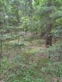
View from hash


Achievements
Torodeas earned the Land geohash achievement
|
Torodeas earned the Public transport geohash achievement
|