Difference between revisions of "2024-07-02 43 6"
(Created page with "{{graticule | lat=43 | lon=6 | date=2024-07-02 }} == Location == Under an electric pylon near Grasse, France == Participants == ShadowCat,User:...") |
(→Achievements) |
||
| (15 intermediate revisions by 3 users not shown) | |||
| Line 1: | Line 1: | ||
| − | {{graticule | + | {{meetup graticule |
| lat=43 | | lat=43 | ||
| lon=6 | | lon=6 | ||
| date=2024-07-02 | | date=2024-07-02 | ||
}} | }} | ||
| − | |||
== Location == | == Location == | ||
| Line 11: | Line 10: | ||
== Participants == | == Participants == | ||
| − | [[User:ShadowCat|ShadowCat]] | + | *[[User:ShadowCat|ShadowCat]] |
| + | *[[User:ShadowCat|ShadowCat]]'s mom and | ||
| + | *[[User:ShadowCat|ShadowCat]]'s brother who haven't made an account yet | ||
| − | == Plans == | + | == Plans (or how I decided to go to a random spot in the woods for the first time) == |
| − | I' | + | The planning part of the expedition went pretty much like this: |
| + | As finished everything I had to do in the morning, I opened geohashing.info to check if the hash was feasible, at first it looked pretty tough: it was 2 kilometres deep in some pretty thick woods, which would have been a lot for an unexperienced geohasher like me. But then I had a realization: "''There's a path!''". | ||
| + | |||
| + | The hash was near the base of an electrical pylon, which had a clear path leading to it, this instantly turned this into an easy expedition, perfect for my first ever geohash. | ||
== Expedition == | == Expedition == | ||
| + | {{clear}} | ||
| + | |||
| + | The first obstacle was met even before leaving the house: I had to convince my mother to let me venture to a random spot in a forest. But I managed to do that pretty easily, mostly because I need practice driving a real car, so she decided that we would go together. | ||
| + | |||
| + | And so, an hour later, me, my mum and my unwilling brother set out to go to the hash. After a 40-minute drive, we got to a spot near the beginning of the path. We parked the car and continued on foot. It all started off pretty normally, with me and my brother walking, running and singing the LotR theme. But everything changed when my brother stopped to look up the hill, and then this happened: | ||
| + | I asked: "What are you doing?" | ||
| + | My brother: "..." | ||
| + | Me, slightly louder: "What are you doing?" | ||
| + | My brother: "There's a ''stick''" | ||
| + | Five seconds later, we were running like before, but now carrying a 2-meter long stick. | ||
| − | + | A few hundreds of meters later, we even managed to find a use of the stick: we hung the bag pack with our water bottle inside on the stick, and then each of us grabbed an end of the stick to equally spread the load between the two of us (and mom was busy taking pictures). | |
| + | I was now <span style="text-decoration: line-through;">free</span> half-free from burden of a bag filled with a single water bottle, and could now run <span style="text-decoration: line-through;">much faster</span>, <span style="text-decoration: line-through;">slightly faster</span>, at the same speed but holding a stick with one arm. And after a few more hundreds of meters, the huge pylon was in sight. | ||
| + | But our journey wasn't over at the pylon, we now had to venture off the beaten path to find the hash. | ||
| + | Thankfully, it was only a 50 meter walk, so it really wasn't that bad. | ||
| − | + | I then had a realization: the tree I was sitting on looked very climbable, so I decided to try to get an achievement by climbing it. | |
| − | |||
| − | + | We then walked back to the car, <span style="text-decoration: line-through;">putting</span> throwing the stick back where we found it. | |
| + | |||
| + | == Photos == | ||
| + | <gallery mode="packed" heights="175px"> | ||
| + | File:RunningWithTheStick.jpg|thumb|Running with the stick | ||
| + | File:WalkingWithTheStick.jpg|thumb|It was a useful stick | ||
| + | File:MeAndThePylon.png|thumb|I am in this picture | ||
| + | </gallery> | ||
| + | <gallery mode="packed" heights="250px"> | ||
| + | File:Proof2024-07-02 43-6.jpg | Proof of the geohash using Geohash Droid | ||
| + | File:Multiple elevations1 2024-07-02 43-6.jpg | Does this counts for the multiple elevations achivement? | ||
| + | File:Multiple Elevations2 2024-07-02 43-6.jpg | And is this enough proof? | ||
| + | </gallery> | ||
== Achievements == | == Achievements == | ||
| − | + | {{land geohash | |
| + | |date=2024-07-02 | ||
| + | |latitude=43 | ||
| + | |longitude=6 | ||
| + | |name=[[User:ShadowCat|ShadowCat]] | ||
| + | |image= | ||
| + | }} | ||
| + | {{Multiple Elevations Team Achievement | latitude = 43 | longitude = 6 | date = 2024-07-02 | level = 2 | names = [[User:ShadowCat|ShadowCat]] }} | ||
| + | __NOTOC__ | ||
[[Category:Expeditions]] | [[Category:Expeditions]] | ||
[[Category:Expeditions with photos]] | [[Category:Expeditions with photos]] | ||
| + | [[Category:Coordinates reached]] | ||
| + | {{location|FR|06}} | ||
Latest revision as of 06:03, 4 July 2024
| Tue 2 Jul 2024 in 43,6: 43.7160763, 6.8140392 geohashing.info google osm bing/os kml crox |
Location
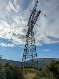
Under an electric pylon near Grasse, France
Participants
Plans (or how I decided to go to a random spot in the woods for the first time)
The planning part of the expedition went pretty much like this: As finished everything I had to do in the morning, I opened geohashing.info to check if the hash was feasible, at first it looked pretty tough: it was 2 kilometres deep in some pretty thick woods, which would have been a lot for an unexperienced geohasher like me. But then I had a realization: "There's a path!".
The hash was near the base of an electrical pylon, which had a clear path leading to it, this instantly turned this into an easy expedition, perfect for my first ever geohash.
Expedition
The first obstacle was met even before leaving the house: I had to convince my mother to let me venture to a random spot in a forest. But I managed to do that pretty easily, mostly because I need practice driving a real car, so she decided that we would go together.
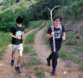
And so, an hour later, me, my mum and my unwilling brother set out to go to the hash. After a 40-minute drive, we got to a spot near the beginning of the path. We parked the car and continued on foot. It all started off pretty normally, with me and my brother walking, running and singing the LotR theme. But everything changed when my brother stopped to look up the hill, and then this happened: I asked: "What are you doing?" My brother: "..." Me, slightly louder: "What are you doing?" My brother: "There's a stick" Five seconds later, we were running like before, but now carrying a 2-meter long stick.
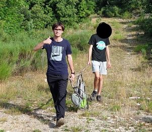
A few hundreds of meters later, we even managed to find a use of the stick: we hung the bag pack with our water bottle inside on the stick, and then each of us grabbed an end of the stick to equally spread the load between the two of us (and mom was busy taking pictures). I was now free half-free from burden of a bag filled with a single water bottle, and could now run much faster, slightly faster, at the same speed but holding a stick with one arm. And after a few more hundreds of meters, the huge pylon was in sight. But our journey wasn't over at the pylon, we now had to venture off the beaten path to find the hash. Thankfully, it was only a 50 meter walk, so it really wasn't that bad.
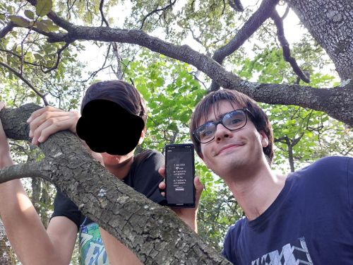
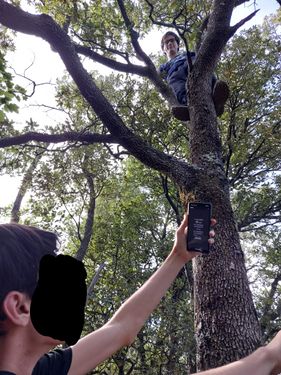
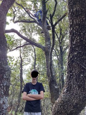
I then had a realization: the tree I was sitting on looked very climbable, so I decided to try to get an achievement by climbing it.
We then walked back to the car, putting throwing the stick back where we found it.
Photos
Achievements
ShadowCat earned the Land geohash achievement
|
ShadowCat earned the Level 2 Multiple elevations achievement (team)
|
