Difference between revisions of "2024-07-22 44 -123"
From Geohashing
(Created page with "{{subst:expedition}}") |
m (Location) |
||
| (3 intermediate revisions by 2 users not shown) | |||
| Line 1: | Line 1: | ||
| − | + | [[Image:2024-07-22 44 -123 geohasher.jpeg|thumb|left]] | |
| − | + | {{meetup graticule|date=2024-07-22|lat=44|lon=-123}} | |
| − | [[Image: | ||
| − | |||
| − | |||
| − | |||
| − | |||
| − | |||
| − | |||
== Location == | == Location == | ||
| − | + | Slightly off Southwest Plymouth Drive, in Philomath | |
== Participants == | == Participants == | ||
| − | + | * [[User:JesseFTW]]'s parents | |
| − | |||
== Plans == | == Plans == | ||
| − | + | I ([[User:JesseFTW]]) told them about the location around 2 PM; it would have been about a half hour walk for them, so they considered that, but decided to drive instead. | |
== Expedition == | == Expedition == | ||
| − | + | My mom provided the following report (slightly edited): | |
| + | : Around a mile from our hilltop oak forested home, a recently mowed field. The only building in sight is the church and nursery school across the street. Plymouth Dr is a popular way to avoid downtown Philomath to the north while the main street is under major overhaul. I am wearing my Dirt First tee shirt. | ||
| − | + | Sadly, they didn't quite get to the hashpoint, as it was too far from the road for them to feel comfortable trespassing. | |
| − | |||
== Photos == | == Photos == | ||
| − | |||
| − | |||
| − | |||
<gallery perrow="5"> | <gallery perrow="5"> | ||
| + | File:2024-07-22 44 -123 field.jpeg | The field, with hay bales in the distance. | ||
| + | File:2024-07-22 44 -123 church sign.jpeg | The church sign, opposite the hashpoint. | ||
| + | File:2024-07-22 44 -123 geohasher.jpeg | Geohasher, without Silly Grin due to not making it to the hashpoint. | ||
</gallery> | </gallery> | ||
| − | |||
| − | |||
| − | |||
| − | |||
__NOTOC__ | __NOTOC__ | ||
| − | |||
| − | |||
| − | |||
| − | |||
| − | |||
| − | |||
| − | |||
| − | |||
| − | |||
| − | |||
[[Category:Expeditions]] | [[Category:Expeditions]] | ||
| − | |||
[[Category:Expeditions with photos]] | [[Category:Expeditions with photos]] | ||
| − | |||
| − | |||
| − | |||
| − | |||
| − | |||
| − | |||
| − | |||
[[Category:Coordinates not reached]] | [[Category:Coordinates not reached]] | ||
| − | |||
| − | |||
| − | |||
| − | |||
| − | |||
[[Category:Not reached - No public access]] | [[Category:Not reached - No public access]] | ||
| − | + | {{location|US|OR|BE}} | |
| − | |||
| − | |||
| − | |||
| − | |||
Latest revision as of 12:42, 23 July 2024

| Mon 22 Jul 2024 in 44,-123: 44.5378810, -123.3136979 geohashing.info google osm bing/os kml crox |
Location
Slightly off Southwest Plymouth Drive, in Philomath
Participants
- User:JesseFTW's parents
Plans
I (User:JesseFTW) told them about the location around 2 PM; it would have been about a half hour walk for them, so they considered that, but decided to drive instead.
Expedition
My mom provided the following report (slightly edited):
- Around a mile from our hilltop oak forested home, a recently mowed field. The only building in sight is the church and nursery school across the street. Plymouth Dr is a popular way to avoid downtown Philomath to the north while the main street is under major overhaul. I am wearing my Dirt First tee shirt.
Sadly, they didn't quite get to the hashpoint, as it was too far from the road for them to feel comfortable trespassing.
Photos
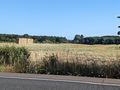
The field, with hay bales in the distance.
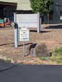
The church sign, opposite the hashpoint.
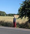
Geohasher, without Silly Grin due to not making it to the hashpoint.

