Difference between revisions of "2024-07-25 51 13"
From Geohashing
(→Plans) |
m (Location) |
||
| (3 intermediate revisions by one other user not shown) | |||
| Line 12: | Line 12: | ||
== Participants == | == Participants == | ||
| − | [[User:Oisín|Oisín]] | + | |
| + | [[User:Oisín|Oisín]] went by bike up the Grundstraße after work and shopping in the market at Schillerplatz | ||
== Plans == | == Plans == | ||
| − | The hash seems to be located on private ground but as [[User:Oisín|Oisín]] | + | The hash seems to be located on private ground but as [[User:Oisín|Oisín]] wants to go on a bike ride after work it might be worth a try anyway. |
== Expedition == | == Expedition == | ||
| − | |||
| − | == | + | === [[User:Oisín|Oisín]] === |
| − | + | ||
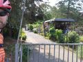
| + | After work I cycled to Schillerplatz to buy some locale fruits and vegetables at the market. I then took the Grundstraße climb up to Bühlau and continued to the hash point via Weißig. As I feared the hash point is located on private ground and was not accessible to the public. | ||
== Photos == | == Photos == | ||
| − | |||
| − | |||
| − | |||
<gallery perrow="5"> | <gallery perrow="5"> | ||
| + | Image:2024-07-25 51 13 Oisín Geohash Droid.jpg | 15m off :-( | ||
| + | Image:2024-07-25 51 13 Oisín.jpeg | stupid grin at the gate | ||
</gallery> | </gallery> | ||
| Line 35: | Line 35: | ||
__NOTOC__ | __NOTOC__ | ||
| − | |||
| − | |||
| − | |||
| − | |||
| − | |||
| − | |||
| − | |||
| − | |||
| − | |||
[[Category:Expeditions]] | [[Category:Expeditions]] | ||
| − | |||
[[Category:Expeditions with photos]] | [[Category:Expeditions with photos]] | ||
| − | |||
| − | |||
| − | |||
| − | |||
| − | |||
| − | |||
| − | |||
[[Category:Coordinates not reached]] | [[Category:Coordinates not reached]] | ||
| − | |||
| − | |||
| − | |||
| − | |||
| − | |||
[[Category:Not reached - No public access]] | [[Category:Not reached - No public access]] | ||
| − | + | {{location|DE|SN|DD}} | |
| − | |||
| − | |||
| − | |||
| − | |||
Latest revision as of 09:42, 26 July 2024
| Thu 25 Jul 2024 in 51,13: 51.0712023, 13.8783776 geohashing.info google osm bing/os kml crox |
Location
The hash is located in a small residential area in the far north east of the city of Dresden near the Dresdner Heide forest.
Participants
Oisín went by bike up the Grundstraße after work and shopping in the market at Schillerplatz
Plans
The hash seems to be located on private ground but as Oisín wants to go on a bike ride after work it might be worth a try anyway.
Expedition
Oisín
After work I cycled to Schillerplatz to buy some locale fruits and vegetables at the market. I then took the Grundstraße climb up to Bühlau and continued to the hash point via Weißig. As I feared the hash point is located on private ground and was not accessible to the public.
Photos

15m off :-(
stupid grin at the gate

