Difference between revisions of "2024-08-05 55 -3"
m |
m |
||
| (2 intermediate revisions by the same user not shown) | |||
| Line 1: | Line 1: | ||
{{meetup graticule|date=2024-08-05|lat=55|lon=-3}} | {{meetup graticule|date=2024-08-05|lat=55|lon=-3}} | ||
{{location|GB|SCT|NLK}} | {{location|GB|SCT|NLK}} | ||
| − | {{user categories|user=KerrMcF}} | + | {{user categories|user=KerrMcF|car=76.6|foot=2.3}} |
== Location == | == Location == | ||
| Line 17: | Line 17: | ||
== Expedition == | == Expedition == | ||
| + | === KerrMcF === | ||
| + | As planned, I drove to Cumbernauld, arriving shortly after 12:00pm. Gaelan was there waiting, so they got into the car, and we drove along a very twisty 60mph single-track road for 10 minutes or so until we reached Upperton, where we parked. We then walked along the old rail line that I had spotted when planning the expedition until turning off and walking along a sort of path towards the geohash. This path ended up being the wrong path, so we turned back, took a different one, and got to the geohash fairly easily. | ||
| + | |||
| + | After taking photos and proof, we decided it might be easier to leave the field via the road and walk along this back to Upperton, despite there being no "side-pavement". We made our way back to Upperton before I drove Gaelan back to Cumbernauld station - during which Google's navigation tried to make us take a slip road on the other side of the road(???) - so that she could get her train, and then left to drive back home. The rain on the drive home was the heaviest I've seen in months (thanks for the jinx, Gaelan) but there were no issues with the drive itself, other than dodgy drivers in front of me (one singular break light working? really?). Both the drive to the geohash and the drive back went past the geohash from two expeditions ago, which is now seeming a lot more common than it previously had when I mentioned it in my last report. | ||
| + | |||
| + | I forgot to record the route we walked on my watch, but it seems to think I walked for 2.3km. I've checked this against BRouter to the best of my ability, and it seems to agree that it's around that number, so I've used that for the user categories template. 'Upperton' also feels quite Tale of Two Hashes-y, so I've made a challenge for that. | ||
== Photos == | == Photos == | ||
| + | <gallery> | ||
| + | File:2024-08-05 55 -3 Proof1.jpg | At the geohash | ||
| + | File:2024-08-05 55 -3 Proof2.jpg | Wider view | ||
| + | File:2024-08-05 55 -3 Meetup.jpg | Successful meetup | ||
| + | File:2024-08-05 55 -3 Panorama.jpg | Panorama from the geohash | ||
| + | </gallery> | ||
== Achievements == | == Achievements == | ||
| − | + | {{land geohash | latitude = 55 | longitude = -3 | date = 2024-08-05 | name = KerrMcF and Gaelan}} | |
| − | {{land geohash | latitude = 55 | longitude = -3 | date = 2024-08-05 | name = KerrMcF}} | + | {{consecutive geohash 3 | hashcount = 2 | daycount = 2 | latitude = 55 | longitude = -3 | date = 2024-08-04 | name = KerrMcF}} |
| − | {{consecutive geohash 3 | hashcount = 2 | daycount = 2 | latitude = 55 | longitude = -3 | date = 2024-08-04 | name = KerrMcF}} | + | {{Meet-up | latitude = 55 | longitude = -3 | date = 2024-08-05 | name = KerrMcF and Gaelan | other = each other}} |
| − | {{Meet-up | latitude = 55 | longitude = -3 | date = 2024-08-05 | name = KerrMcF}} | + | {{A Tale of Two Hashes challenge | latitude = 55 | longitude = -3 | date = 2024-08-05 | place = Upperton | name = KerrMcF and Gaelan}} |
| − | {{ | ||
| − | |||
| − | |||
== Progress == | == Progress == | ||
{|class="wikitable" | {|class="wikitable" | ||
| Line 35: | Line 44: | ||
| North Lanarkshire || ML(6) || UKM84 || 99 || Meet-up achievement | | North Lanarkshire || ML(6) || UKM84 || 99 || Meet-up achievement | ||
|} | |} | ||
| − | |||
| − | |||
{{KerrMcF Nav | previous = 2024-08-04 55 -3}} | {{KerrMcF Nav | previous = 2024-08-04 55 -3}} | ||
| − | |||
| − | |||
| − | |||
| − | |||
| − | |||
| − | |||
| − | |||
| − | [[Category: | + | [[Category:Expeditions]] [[Category:Coordinates reached]] [[Category:Expeditions with photos]] |
Latest revision as of 17:31, 5 August 2024
| Mon 5 Aug 2024 in 55,-3: 55.9200070, -3.9197153 geohashing.info google osm bing/os kml crox |
Contents
Location
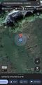
In a field near Upperton.
Participants
Plans
KerrMcF
I don't have any other plans this day, so I'll head out here sometime after lunch. The drive to the nearby village of Upperton seems relatively simple, and it looks like an old railway line leads from this village to the field containing the geohash, so I'll walk a short distance along this. It should be a relatively simple expedition, with the only potential issue being the accessibility of the field.
New plans! Gaelan and I are planning to head to this geohash together, meeting at the nearby town of Cumbernauld. I'll leave to drive there at 11:15am, arriving around 11:45am in time for Gaelan's train arriving. We'll then drive to Upperton together - only 10 minutes away - and walk to the geohash. Then we'll do the same in reverse.
Expedition
KerrMcF
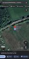
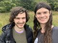
As planned, I drove to Cumbernauld, arriving shortly after 12:00pm. Gaelan was there waiting, so they got into the car, and we drove along a very twisty 60mph single-track road for 10 minutes or so until we reached Upperton, where we parked. We then walked along the old rail line that I had spotted when planning the expedition until turning off and walking along a sort of path towards the geohash. This path ended up being the wrong path, so we turned back, took a different one, and got to the geohash fairly easily.
After taking photos and proof, we decided it might be easier to leave the field via the road and walk along this back to Upperton, despite there being no "side-pavement". We made our way back to Upperton before I drove Gaelan back to Cumbernauld station - during which Google's navigation tried to make us take a slip road on the other side of the road(???) - so that she could get her train, and then left to drive back home. The rain on the drive home was the heaviest I've seen in months (thanks for the jinx, Gaelan) but there were no issues with the drive itself, other than dodgy drivers in front of me (one singular break light working? really?). Both the drive to the geohash and the drive back went past the geohash from two expeditions ago, which is now seeming a lot more common than it previously had when I mentioned it in my last report.
I forgot to record the route we walked on my watch, but it seems to think I walked for 2.3km. I've checked this against BRouter to the best of my ability, and it seems to agree that it's around that number, so I've used that for the user categories template. 'Upperton' also feels quite Tale of Two Hashes-y, so I've made a challenge for that.
Photos
At the geohash
Wider view
Successful meetup
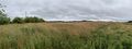
Panorama from the geohash


Achievements
KerrMcF and Gaelan earned the Land geohash achievement
|
KerrMcF earned the Consecutive geohash achievement
|
KerrMcF and Gaelan earned the Meet-up achievement
|

Progress
| Council Area | Postcode | NUTS | Centicule | New Achievements |
|---|---|---|---|---|
| North Lanarkshire | ML(6) | UKM84 | 99 | Meet-up achievement |
| Expedition Navigation | ||
|---|---|---|
| KerrMcF's expeditions | No Next Yet | |