Difference between revisions of "2024-08-06 49 8"
Coyotebush (talk | contribs) ([live picture]It's across the road [https://openstreetmap.org/?mlat=49.21847778&mlon=8.31842500&zoom=16 @49.2185,8.3184]) |
Coyotebush (talk | contribs) (→Achievements: consecutive) |
||
| (6 intermediate revisions by 2 users not shown) | |||
| Line 7: | Line 7: | ||
{{meetup graticule|date=2024-08-06|lat=49|lon=8}} | {{meetup graticule|date=2024-08-06|lat=49|lon=8}} | ||
== Location == | == Location == | ||
| − | + | Next to the L538 road, in the middle of the Bellheimer Wald near Germersheim. | |
== Participants == | == Participants == | ||
| − | *[[User:Coyotebush| | + | *[[User:Coyotebush|coyotebush]] |
== Plans == | == Plans == | ||
| Line 17: | Line 17: | ||
== Expedition == | == Expedition == | ||
| + | I used DB Navigator to plot a journey with a 1-hour stopover at Bellheim Bf - not Germersheim, which could have put me on a regional express train and thence a gravel road east-west through the forest. This started off great. | ||
| + | *Successful transfer at Karlsruhe Hbf -- [[User:Coyotebush|Coyotebush]] ([[User talk:Coyotebush|talk]]) [https://openstreetmap.org/?mlat=48.99325110&mlon=8.39880972&zoom=16 @48.9933,8.3988] 12:07, 6 August 2024 (GMT+02:00) | ||
| + | |||
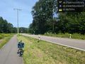
| + | I started riding from Bellheim and soon found the cycle path along L538. A few fields separated the town from the forest. | ||
| + | |||
| + | Garmin got me to the closest part of the path, then Geohash Droid pointed me across the road. Traffic was intermittent, so it was easy to dash across for some photos. Cell signal was too weak to re-load imagery or upload photos. | ||
| + | |||
| + | While Lingenfeld was slightly farther away, it would gain me about 20 minutes off the train, which still looked like enough time for lunch. I passed a cyclist-filled cafe next to the tracks in Westheim, then a fried chicken food truck in the Lingenfeld square, before deciding on a falafel wrap from the nearby döner shop. I took this to the station to eat, which avoided any anxiety about reaching the station (and the other side of the tracks in time). There I found a sheltered seat and plenty of time. | ||
| + | |||
| + | As I ate, DB notified me that I might miss rejoining an ICE in Mannheim, and I realized the planned journey had counted on a 5-minute transfer. By running, I made it barely on time... and then the overcrowded train didn't depart for another 20 minutes. At the next stop in Mainz, many of us were asked to leave to make room, and I ended up on a slow regional train for the rest of my travel day. | ||
| + | |||
| + | == Tracklog == | ||
| + | Bike ride: | ||
| + | {{tracklog|2024-08-06 49 8 bike.gpx}} | ||
| − | |||
== Photos == | == Photos == | ||
<!-- | <!-- | ||
| Line 31: | Line 44: | ||
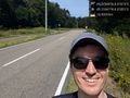
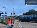
Image:2024-08-06_49_8_coyotebush_1722950619386.jpg|It's across the road [https://openstreetmap.org/?mlat=49.21847778&mlon=8.31842500&zoom=16 @49.2185,8.3184] | Image:2024-08-06_49_8_coyotebush_1722950619386.jpg|It's across the road [https://openstreetmap.org/?mlat=49.21847778&mlon=8.31842500&zoom=16 @49.2185,8.3184] | ||
| + | |||
| + | Image:2024-08-06_49_8_coyotebush_1722950647418.jpg|Grin [https://openstreetmap.org/?mlat=49.21840833&mlon=8.31850556&zoom=16 @49.2184,8.3185] | ||
| + | |||
| + | Image:2024-08-06_49_8_coyotebush_1722950688862.jpg|Location screenshot | ||
| + | |||
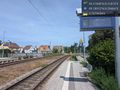
| + | Image:2024-08-06_49_8_coyotebush_1722950762842.jpg|Arriving at Lingenfeld Bahnhof [https://openstreetmap.org/?mlat=49.25189444&mlon=8.34933056&zoom=16 @49.2519,8.3493] | ||
</gallery> | </gallery> | ||
| Line 36: | Line 55: | ||
== Achievements == | == Achievements == | ||
{{#vardefine:ribbonwidth|100%}} | {{#vardefine:ribbonwidth|100%}} | ||
| + | {{consecutive geohash | ||
| + | |||
| + | | count = 3 | ||
| + | | latitude = 47 | ||
| + | | longitude = 7 | ||
| + | | date = 2024-08-04 | ||
| + | | name = [[User:coyotebush|coyotebush]] | ||
| + | |||
| + | }} | ||
__NOTOC__ | __NOTOC__ | ||
| − | |||
| − | |||
| − | |||
| − | |||
[[Category:Expeditions]] | [[Category:Expeditions]] | ||
| Line 47: | Line 71: | ||
[[Category:Coordinates reached]] | [[Category:Coordinates reached]] | ||
| − | + | {{location|DE|RP|GER}} | |
| − | |||
| − | |||
| − | |||
| − | |||
| − | |||
| − | |||
| − | |||
Latest revision as of 19:06, 21 August 2024
| Tue 6 Aug 2024 in 49,8: 49.2184830, 8.3187400 geohashing.info google osm bing/os kml crox |
Location
Next to the L538 road, in the middle of the Bellheimer Wald near Germersheim.
Participants
Plans
I'll be traveling north along the Rhine for the day, and may route this way via the S3 train and a bike ride (e.g. Bellheim to Lingenfeld).
Expedition
I used DB Navigator to plot a journey with a 1-hour stopover at Bellheim Bf - not Germersheim, which could have put me on a regional express train and thence a gravel road east-west through the forest. This started off great.
- Successful transfer at Karlsruhe Hbf -- Coyotebush (talk) @48.9933,8.3988 12:07, 6 August 2024 (GMT+02:00)
I started riding from Bellheim and soon found the cycle path along L538. A few fields separated the town from the forest.
Garmin got me to the closest part of the path, then Geohash Droid pointed me across the road. Traffic was intermittent, so it was easy to dash across for some photos. Cell signal was too weak to re-load imagery or upload photos.
While Lingenfeld was slightly farther away, it would gain me about 20 minutes off the train, which still looked like enough time for lunch. I passed a cyclist-filled cafe next to the tracks in Westheim, then a fried chicken food truck in the Lingenfeld square, before deciding on a falafel wrap from the nearby döner shop. I took this to the station to eat, which avoided any anxiety about reaching the station (and the other side of the tracks in time). There I found a sheltered seat and plenty of time.
As I ate, DB notified me that I might miss rejoining an ICE in Mannheim, and I realized the planned journey had counted on a 5-minute transfer. By running, I made it barely on time... and then the overcrowded train didn't depart for another 20 minutes. At the next stop in Mainz, many of us were asked to leave to make room, and I ended up on a slow regional train for the rest of my travel day.
Tracklog
Bike ride:
Photos
Bellheim Bahnhof @49.1891,8.2946
It's across the road @49.2185,8.3184
Grin @49.2184,8.3185
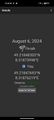
Location screenshot
Arriving at Lingenfeld Bahnhof @49.2519,8.3493


Achievements
coyotebush earned the Consecutive geohash achievement
|