Difference between revisions of "2024-08-06 53 -6"
Gefrierbrand (talk | contribs) (An expedition message sent via Geohash Droid for Android.) |
Gefrierbrand (talk | contribs) (→Expedition) |
||
| (7 intermediate revisions by 2 users not shown) | |||
| Line 1: | Line 1: | ||
| − | + | {{meetup graticule|date=2024-08-06|lat=53|lon=-6}} | |
| − | |||
| − | |||
| − | |||
| − | |||
| − | |||
| − | |||
| − | |||
| − | |||
== Location == | == Location == | ||
| − | + | In a heather field somewhere on Glassamucky Breaks south of Dublin. | |
== Participants == | == Participants == | ||
| − | + | * [[User:Gefrierbrand|Gefrierbrand]] | |
| − | + | * [[User:Santu|Santu]] | |
== Plans == | == Plans == | ||
| − | + | Fly to Ireland, get a rental car, drive around and see what's possible. | |
== Expedition == | == Expedition == | ||
| − | + | Thanks to the [[30W Time Zone Rule|30°W Rule]], we had already noticed the Geo-# location the day before we left for Ireland and decided to at least give it a go if the conditions would be favorable. The hash was close to our indented route after all. Thankfully, our flight went as scheduled and getting the rental car as well as supplies was without issues. | |
| − | + | Driving on the ''objectively'' wrong side of the road needed some getting used to, but we managed to safely get around Dublin and as soon as we entered the more rural areas it quickly stopped to matter since the roads where just narrowly bigger than our car anyways. | |
| − | + | ||
| + | We found an overtaking spot near the hash and parked there, greeted by some very well-behaved sheep. We then walked uphill through thick heather-like plants for about 100m before we reached the location. Luckily our initial fears of wet plants or hard to notice holes in the ground were unfounded and we made quick and dry progress. | ||
| + | |||
| + | Right after we had reached the hash and returned to our car, a very heavy rainstorm approached out of nowhere! However our timing was perfect and what would otherwise definitively have been a drowned rat geohash was only a "drive very slowly and carefully" adventure. | ||
| + | |||
| + | Shortly afterwards the rain was gone as quickly as it came and we continued our trip through this magnificently beautiful landscape. | ||
== Photos == | == Photos == | ||
| Line 29: | Line 26: | ||
--> | --> | ||
<gallery perrow="5"> | <gallery perrow="5"> | ||
| + | Image:2024-08-06_53_-6_Gefrierbrand_1722963823902.jpg|Santu ascending towards the hash | ||
| + | Image:2024-08-06_53_-6_Gefrierbrand_1722963577290.jpg|StupidGrin<sup>TM</sup> | ||
| + | Image:2024-08-06_53_-6_Gefrierbrand_1722963757020.jpg|Beautiful area with rain in the distance | ||
| + | Image:2024-08-06_53_-6_Gefrierbrand_1722963928170.jpg|Sheep blocking the bridge | ||
| + | Image:2024-08-06_53_-6_Gefrierbrand_1722963528287.jpg|proof | ||
</gallery> | </gallery> | ||
== Achievements == | == Achievements == | ||
{{#vardefine:ribbonwidth|100%}} | {{#vardefine:ribbonwidth|100%}} | ||
| − | + | {{land geohash | |
| + | |||
| + | | latitude = 53 | ||
| + | | longitude = -6 | ||
| + | | date = 2024-08-06 | ||
| + | | name = Santu & Gefierbrand | ||
| + | }} | ||
__NOTOC__ | __NOTOC__ | ||
| − | |||
| − | |||
| − | |||
| − | |||
| − | |||
| − | |||
| − | |||
| − | |||
| − | |||
| − | |||
[[Category:Expeditions]] | [[Category:Expeditions]] | ||
| − | |||
[[Category:Expeditions with photos]] | [[Category:Expeditions with photos]] | ||
| − | |||
| − | |||
| − | |||
| − | |||
[[Category:Coordinates reached]] | [[Category:Coordinates reached]] | ||
| − | + | {{location|IE|L|D}} | |
| − | |||
| − | |||
| − | |||
| − | |||
| − | |||
| − | |||
| − | |||
| − | |||
| − | |||
| − | |||
| − | |||
| − | |||
| − | |||
Latest revision as of 18:47, 6 August 2024
| Tue 6 Aug 2024 in 53,-6: 53.2184830, -6.3187400 geohashing.info google osm bing/os kml crox |
Location
In a heather field somewhere on Glassamucky Breaks south of Dublin.
Participants
Plans
Fly to Ireland, get a rental car, drive around and see what's possible.
Expedition
Thanks to the 30°W Rule, we had already noticed the Geo-# location the day before we left for Ireland and decided to at least give it a go if the conditions would be favorable. The hash was close to our indented route after all. Thankfully, our flight went as scheduled and getting the rental car as well as supplies was without issues.
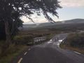
Driving on the objectively wrong side of the road needed some getting used to, but we managed to safely get around Dublin and as soon as we entered the more rural areas it quickly stopped to matter since the roads where just narrowly bigger than our car anyways.
We found an overtaking spot near the hash and parked there, greeted by some very well-behaved sheep. We then walked uphill through thick heather-like plants for about 100m before we reached the location. Luckily our initial fears of wet plants or hard to notice holes in the ground were unfounded and we made quick and dry progress.
Right after we had reached the hash and returned to our car, a very heavy rainstorm approached out of nowhere! However our timing was perfect and what would otherwise definitively have been a drowned rat geohash was only a "drive very slowly and carefully" adventure.
Shortly afterwards the rain was gone as quickly as it came and we continued our trip through this magnificently beautiful landscape.
Photos
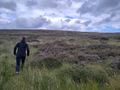
Santu ascending towards the hash
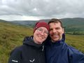
StupidGrinTM

Beautiful area with rain in the distance
Sheep blocking the bridge

proof


Achievements
Santu & Gefierbrand earned the Land geohash achievement
|