Difference between revisions of "2024-08-07 47 -122"
([live picture]Entrance [https://openstreetmap.org/?mlat=47.81352497&mlon=-122.28492400&zoom=16 @47.8135,-122.2849]) |
|||
| (3 intermediate revisions by the same user not shown) | |||
| Line 1: | Line 1: | ||
| − | + | {{meetup graticule|date=2024-08-07|lat=47|lon=-122| graticule_name=Seattle | |
| + | | graticule_link=Seattle, Washington }} | ||
| − | |||
| − | |||
| − | |||
| − | |||
| − | |||
| − | |||
| − | |||
== Location == | == Location == | ||
| − | + | Amidst some trees, near the freeway in Lynnwood WA | |
== Participants == | == Participants == | ||
| − | + | * [[User:Thomcat|Thomcat]] | |
| − | |||
== Plans == | == Plans == | ||
| − | + | Stop by after work | |
== Expedition == | == Expedition == | ||
| − | + | The point is fairly close to my commute path. Did some streetview investigation of the entrance to Ziply (a local broadband provider) and didn't see any signs, so I figured I'd give it a go. Shorts and sandals aren't the right wear for either traipsing into the woods or dealing with velociraptors, but I would cross that bridge when I came to it. | |
| + | |||
| + | Drove down a road I've been down before and took a right turn I hadn't, still looks good. Snapped a photo of the Ziply sign. Continued a little further and there is a likely-broken intercom next to an open gate... labeled with two types of No Trespassing signs. I briefly considered going further, but that's not what we do in geohashing. | ||
| + | |||
| + | Leaving the property, I took an immediate right and right again into the property next door. No signs, no restrictions, lots of younger folks. Labeled Zumiez, this is clearly not a retail location - but it does have a cool skate park out back, perhaps for product testing. I parked and walked across a nice lawn to the northeast corner of the property, where I found a protected greenspace sign. If the barbed wire of the previous entrance was anything to go by, I wasn't going to reach the point going this way either. | ||
== Tracklog == | == Tracklog == | ||
| Line 31: | Line 28: | ||
Image:2024-08-07_47_-122_thomcat_1723067399696.jpg|Entrance [https://openstreetmap.org/?mlat=47.81352497&mlon=-122.28492400&zoom=16 @47.8135,-122.2849] | Image:2024-08-07_47_-122_thomcat_1723067399696.jpg|Entrance [https://openstreetmap.org/?mlat=47.81352497&mlon=-122.28492400&zoom=16 @47.8135,-122.2849] | ||
| + | |||
| + | Image:2024-08-07_47_-122_thomcat_1723067492773.jpg|Harumph [https://openstreetmap.org/?mlat=47.81429597&mlon=-122.28549397&zoom=16 @47.8143,-122.2855] | ||
| + | |||
| + | Image:2024-08-07_47_-122_thomcat_1723067763035.jpg|Zumiez looks like a nice place to work [https://openstreetmap.org/?mlat=47.81533000&mlon=-122.28770697&zoom=16 @47.8153,-122.2877] | ||
| + | |||
| + | Image:2024-08-07_47_-122_thomcat_1723067793919.jpg|NE corner - probably no go [https://openstreetmap.org/?mlat=47.81575097&mlon=-122.28723200&zoom=16 @47.8158,-122.2872] | ||
</gallery> | </gallery> | ||
| Line 38: | Line 41: | ||
__NOTOC__ | __NOTOC__ | ||
| − | |||
| − | |||
| − | |||
| − | |||
| − | |||
| − | |||
| − | |||
| − | |||
| − | |||
| − | |||
[[Category:Expeditions]] | [[Category:Expeditions]] | ||
| − | |||
[[Category:Expeditions with photos]] | [[Category:Expeditions with photos]] | ||
| − | |||
| − | |||
| − | |||
| − | |||
| − | |||
| − | |||
| − | |||
[[Category:Coordinates not reached]] | [[Category:Coordinates not reached]] | ||
| − | |||
| − | |||
| − | |||
| − | |||
| − | |||
[[Category:Not reached - No public access]] | [[Category:Not reached - No public access]] | ||
| − | + | {{location|US|WA|SN}} | |
| − | |||
| − | |||
| − | |||
| − | |||
Latest revision as of 13:03, 8 August 2024
| Wed 7 Aug 2024 in Seattle: 47.8162321, -122.2857072 geohashing.info google osm bing/os kml crox |
Location
Amidst some trees, near the freeway in Lynnwood WA
Participants
Plans
Stop by after work
Expedition
The point is fairly close to my commute path. Did some streetview investigation of the entrance to Ziply (a local broadband provider) and didn't see any signs, so I figured I'd give it a go. Shorts and sandals aren't the right wear for either traipsing into the woods or dealing with velociraptors, but I would cross that bridge when I came to it.
Drove down a road I've been down before and took a right turn I hadn't, still looks good. Snapped a photo of the Ziply sign. Continued a little further and there is a likely-broken intercom next to an open gate... labeled with two types of No Trespassing signs. I briefly considered going further, but that's not what we do in geohashing.
Leaving the property, I took an immediate right and right again into the property next door. No signs, no restrictions, lots of younger folks. Labeled Zumiez, this is clearly not a retail location - but it does have a cool skate park out back, perhaps for product testing. I parked and walked across a nice lawn to the northeast corner of the property, where I found a protected greenspace sign. If the barbed wire of the previous entrance was anything to go by, I wasn't going to reach the point going this way either.
Tracklog
Photos
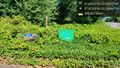
Entrance @47.8135,-122.2849
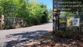
Harumph @47.8143,-122.2855
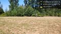
Zumiez looks like a nice place to work @47.8153,-122.2877
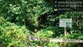
NE corner - probably no go @47.8158,-122.2872


