Difference between revisions of "2024-08-06 48 7"
From Geohashing
m |
m (→Photos: typo) |
||
| (One intermediate revision by the same user not shown) | |||
| Line 9: | Line 9: | ||
== Participants == | == Participants == | ||
* [[User:Baarde|Baarde]] | * [[User:Baarde|Baarde]] | ||
| + | |||
| + | == Expedition == | ||
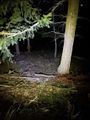
| + | I left home in the late evening and cycled to Bergheim. I left my bicycle at the bottom of a forest trail and hiked to the coordinates. After a little more than a kilometer, I exited the trail and bush-bashed about 150 meters in the dark between the trees. The coordinates were located a little bit downhill from the trail, near the stump of a chopped tree. | ||
| + | |||
| + | I recorded proof then went back toward the trail. I immediately came across a wide logging track that run parallel to the path I had taken, which made the ascent much easier than the descent. | ||
| + | |||
| + | == Photos == | ||
| + | <gallery> | ||
| + | File:2024-08-06 48 7 08.jpg | In Bergheim | ||
| + | File:2024-08-06 48 7 07.jpg | Leaving my bicycle | ||
| + | File:2024-08-06 48 7 02.jpg | Leaving the trail | ||
| + | File:2024-08-06 48 7 03.png | Coordinates reached | ||
| + | File:2024-08-06 48 7 04.jpg | Surroundings (North) | ||
| + | File:2024-08-06 48 7 05.jpg | Surroundings (South) | ||
| + | File:2024-08-06 48 7 06.jpg | Stupid grin | ||
| + | </gallery> | ||
| + | |||
| + | == Achievements == | ||
| + | {{#vardefine:ribbonwidth|100%}} | ||
| + | {{land geohash | ||
| + | | latitude = 48 | ||
| + | | longitude = 7 | ||
| + | | date = 2024-08-06 | ||
| + | | name = [[User:Baarde|Baarde]] | ||
| + | }} | ||
| + | {{bicycle geohash | ||
| + | | latitude = 48 | ||
| + | | longitude = 7 | ||
| + | | date = 2024-08-06 | ||
| + | | name = [[User:Baarde|Baarde]] | ||
| + | | distance = 31 km | ||
| + | | bothways = true | ||
| + | }} | ||
__NOTOC__ | __NOTOC__ | ||
| − | [[Category: | + | [[Category:Expeditions]] |
| + | [[Category:Expeditions with photos]] | ||
| + | [[Category:Coordinates reached]] | ||
{{location|FR|68}} | {{location|FR|68}} | ||
Latest revision as of 10:15, 13 August 2024
| Tue 6 Aug 2024 in 48,7: 48.2184830, 7.3187400 geohashing.info google osm bing/os kml crox |
Location
In the woods, on a mountain above Bergheim.
Participants
Expedition
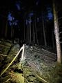
I left home in the late evening and cycled to Bergheim. I left my bicycle at the bottom of a forest trail and hiked to the coordinates. After a little more than a kilometer, I exited the trail and bush-bashed about 150 meters in the dark between the trees. The coordinates were located a little bit downhill from the trail, near the stump of a chopped tree.
I recorded proof then went back toward the trail. I immediately came across a wide logging track that run parallel to the path I had taken, which made the ascent much easier than the descent.
Photos

In Bergheim
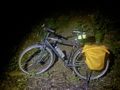
Leaving my bicycle
Leaving the trail
Coordinates reached
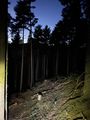
Surroundings (North)
Surroundings (South)
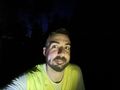
Stupid grin


Achievements
Baarde earned the Land geohash achievement
|
Baarde earned the Bicycle geohash achievement
|