Difference between revisions of "2024-08-20 52 8"
Coyotebush (talk | contribs) ([retro picture]handshake [https://openstreetmap.org/?mlat=52.22866667&mlon=8.92879444&zoom=16 @52.2287,8.9288]) |
Coyotebush (talk | contribs) m (→Ribbons: better match actual Multihash ribbon) |
||
| (9 intermediate revisions by the same user not shown) | |||
| Line 16: | Line 16: | ||
My train was going in the other direction, I took it via Herford to Osnabrück Central, where I started my expedition to [[2024-08-20 52 7]] in Hasbergen. | My train was going in the other direction, I took it via Herford to Osnabrück Central, where I started my expedition to [[2024-08-20 52 7]] in Hasbergen. | ||
| + | |||
| + | ===coyotebush=== | ||
| + | After attempting [[2024-08-20 52 5]], I took the IC train just from Apeldoorn to Osnabrück before transferring to the regional train. Once again, I wanted to complete this expedition in an hour in between trains. | ||
| + | |||
| + | My bike ride started by saying hello again to Fippe, who had hurried to the bus stop but was still waiting. I leapfrogged a bus a few times, presumably his, and briefly went the wrong way at a roundabout. Google Maps had prepared me for the elevation gain but not the steep grade - around 10% in places was a lot for a loaded 6-speed Brompton. Then there was an equally unexpected descent along the east-west path. | ||
| + | |||
| + | Fippe headed south up one stream bed until I noticed we needed to get farther west. I got a good GPS reading and took some photos while Fippe danced around a bit more. We returned north along another stream bed full of ferns. | ||
| + | |||
| + | On the downhill ride, a radar speed sign said my bike was slightly exceeding the speed limit - oops. I went partway across the Weserbrücke to photograph the surroundings then returned to the train station. | ||
| + | |||
| + | Great to meet you too, Fippe! | ||
==Photos== | ==Photos== | ||
| Line 25: | Line 36: | ||
2024-08-20 52 8 05 Site.jpg | The site of the Geohash | 2024-08-20 52 8 05 Site.jpg | The site of the Geohash | ||
2024-08-20 52 8 04 Surroundings.jpg | Surroundings | 2024-08-20 52 8 04 Surroundings.jpg | Surroundings | ||
| + | </gallery> | ||
| + | ===coyotebush=== | ||
| + | <gallery> | ||
Image:2024-08-20_52_8_coyotebush_1724263244856.jpg|climb the hill | Image:2024-08-20_52_8_coyotebush_1724263244856.jpg|climb the hill | ||
Image:2024-08-20_52_8_coyotebush_1724263261332.jpg|descend the path [https://openstreetmap.org/?mlat=52.23001111&mlon=8.93138333&zoom=16 @52.2300,8.9314] | Image:2024-08-20_52_8_coyotebush_1724263261332.jpg|descend the path [https://openstreetmap.org/?mlat=52.23001111&mlon=8.93138333&zoom=16 @52.2300,8.9314] | ||
| + | |||
| + | Image:2024-08-20_52_8_coyotebush_1724268903316.jpg|map screenshot | ||
Image:2024-08-20_52_8_coyotebush_1724263332131.jpg|handshake [https://openstreetmap.org/?mlat=52.22866667&mlon=8.92879444&zoom=16 @52.2287,8.9288] | Image:2024-08-20_52_8_coyotebush_1724263332131.jpg|handshake [https://openstreetmap.org/?mlat=52.22866667&mlon=8.92879444&zoom=16 @52.2287,8.9288] | ||
| + | |||
| + | Image:2024-08-20_52_8_coyotebush_1724263472816.jpg|view from bridge over the rails and the Weser [https://openstreetmap.org/?mlat=52.24177222&mlon=8.91875833&zoom=16 @52.2418,8.9188] | ||
| + | |||
</gallery> | </gallery> | ||
| Line 36: | Line 55: | ||
===Fippe=== | ===Fippe=== | ||
{{tracklog|2024-08-20 52 8 06 Tracklog.gpx}} | {{tracklog|2024-08-20 52 8 06 Tracklog.gpx}} | ||
| + | ===coyotebush('s bike)=== | ||
| + | {{tracklog|2024-08-20 52 8 coyotebush bike.gpx}} | ||
==Ribbons== | ==Ribbons== | ||
| Line 41: | Line 62: | ||
{{land geohash|date=2024-08-20|latitude=52|longitude=8|name=[[User:coyotebush|coyotebush]] and [[User:Fippe|Fippe]]|image=2024-08-20 52 8 03 Handshake.jpg}} | {{land geohash|date=2024-08-20|latitude=52|longitude=8|name=[[User:coyotebush|coyotebush]] and [[User:Fippe|Fippe]]|image=2024-08-20 52 8 03 Handshake.jpg}} | ||
{{meet-up|date=2024-08-20|latitude=52|longitude=8|name=[[User:coyotebush|coyotebush]] and [[User:Fippe|Fippe]]|other=each other|image=2024-08-20 52 8 03 Handshake.jpg}} | {{meet-up|date=2024-08-20|latitude=52|longitude=8|name=[[User:coyotebush|coyotebush]] and [[User:Fippe|Fippe]]|other=each other|image=2024-08-20 52 8 03 Handshake.jpg}} | ||
| + | {{Handshake littlefinger | ||
| + | |||
| + | | date = 2019-07-14 | ||
| + | | number = 5 | ||
| + | | name = [[User:coyotebush|coyotebush]] | ||
| + | |||
| + | }} | ||
| + | {{Radio Yerevan | ||
| + | | achievement = [[Multihash]] Achievement | ||
| + | | detail = at [[2024-08-20 52 5]] he ran out of time to go to the correct side of the fence | ||
| + | | date = 2024-08-20 | ||
| + | | latitude = 52 | ||
| + | | longitude = 8 | ||
| + | | user = [[User:coyotebush|coyotebush]] | ||
| + | }} | ||
__NOTOC__ | __NOTOC__ | ||
Latest revision as of 14:53, 22 August 2024
| Tue 20 Aug 2024 in 52,8: 52.2288004, 8.9292350 geohashing.info google osm bing/os kml crox |
Location
This Geohash is located in a forest in Porta Westfalica.
Participants
Expedition
Fippe
In the afternoon, I took the train eastwards. Coyotebush boarded the train one station after me, at Osnabrück Central, and we took the train to Porta Westfalica together. While we were in the train, the Dow Jones opened and tomorrow's coordinates dropped, which we promptly checked out. Since I did not bring a bike, I took the bus to Hausberge/Badezentrum and walked the rest of the distance, while coyotebush cycled up the hills.
Those modes of transportation turned out to be roughly equal in speed, so we met again at the spot where we would leave the main path to enter the forest. There was a semi-existing path that led us a bit uphill but at some point ceased to be a path. We stumbled through the forest for a bit until we located the coordinates on a different semi-existing path. We zeroed in, officially shook hands, and recorded proof.
Afterwards, we made our way back to the main path, which was considerably easier than the other way around. While I walked back to the station, coyotebush cycled back down to catch his train to Hannover. I was walking just quick enough to say good bye at the station, and the train to Hannover arrived. It was nice to meet you, coyotebush!
My train was going in the other direction, I took it via Herford to Osnabrück Central, where I started my expedition to 2024-08-20 52 7 in Hasbergen.
coyotebush
After attempting 2024-08-20 52 5, I took the IC train just from Apeldoorn to Osnabrück before transferring to the regional train. Once again, I wanted to complete this expedition in an hour in between trains.
My bike ride started by saying hello again to Fippe, who had hurried to the bus stop but was still waiting. I leapfrogged a bus a few times, presumably his, and briefly went the wrong way at a roundabout. Google Maps had prepared me for the elevation gain but not the steep grade - around 10% in places was a lot for a loaded 6-speed Brompton. Then there was an equally unexpected descent along the east-west path.
Fippe headed south up one stream bed until I noticed we needed to get farther west. I got a good GPS reading and took some photos while Fippe danced around a bit more. We returned north along another stream bed full of ferns.
On the downhill ride, a radar speed sign said my bike was slightly exceeding the speed limit - oops. I went partway across the Weserbrücke to photograph the surroundings then returned to the train station.
Great to meet you too, Fippe!
Photos
Fippe
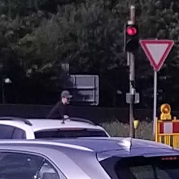
coyotebush being photographed by a creep on the bus, posted with permission

Proof

Shaking hands at the coordinates
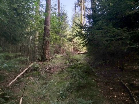
The site of the Geohash
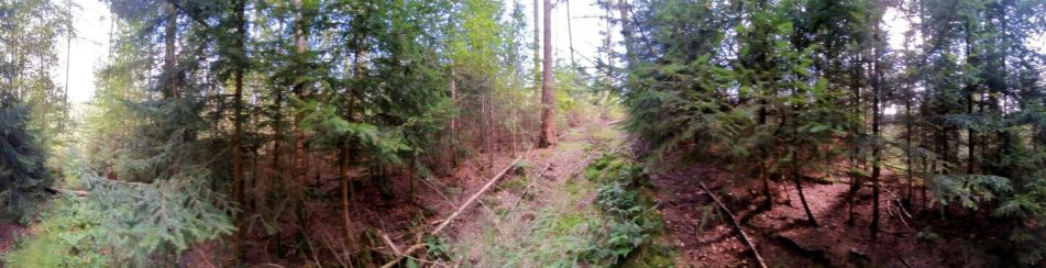
Surroundings


coyotebush
climb the hill
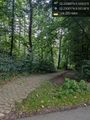
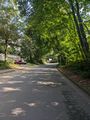
descend the path @52.2300,8.9314
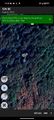
map screenshot
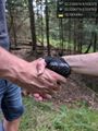
handshake @52.2287,8.9288
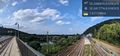
view from bridge over the rails and the Weser @52.2418,8.9188


Tracklog
Fippe
coyotebush('s bike)
Ribbons
coyotebush and Fippe earned the Land geohash achievement
|
coyotebush and Fippe earned the Meet-up achievement
|
coyotebush earned the Little Finger Handshake achievement
|
Is it true that coyotebush earned the Multihash Achievement?
|
- Meetup on 2024-08-20
- Meetup in 52 8
- Expeditions with tracklogs
- Land geohash achievement
- Meet-up achievement
- Handshake achievement
- Radio Yerevan
- Expeditions
- Coordinates reached
- Expeditions with photos
- Meetup in Kreis Minden-Lübbecke
- Expeditions by Fippe
- Fippe's expeditions by bus
- Fippe's expeditions on foot
- Fippe's expeditions by train