Difference between revisions of "2024-08-24 53 8"
Beardygrade (talk | contribs) (→Photos) |
Beardygrade (talk | contribs) (→Achievements) |
||
| (14 intermediate revisions by 3 users not shown) | |||
| Line 1: | Line 1: | ||
| − | + | {{meetup graticule|date=2024-08-24|lat=53|lon=8}} | |
| − | |||
| − | |||
| − | |||
| − | |||
| − | |||
| − | |||
| − | |||
| − | |||
== Location == | == Location == | ||
| − | + | The geohash was located in a wet, grassy rural landscape (Hiddigwardermoor) between Hude and the small river Ollen. It was more or less in the center of a field accessible from the road. | |
== Participants == | == Participants == | ||
| − | + | *[[User:Beardygrade|Beardygrade]] ([[User talk:Beardygrade|talk]]) | |
| − | |||
== Plans == | == Plans == | ||
| − | + | Since the geohash was located roughly in the middle between Oldenburg (where I live) and Bremen (where I had an appointment with a friend), I decided to take my bicycle on a train to Bremen and to make the return journey by bike. | |
== Expedition == | == Expedition == | ||
| − | + | We had a long, pleasant walk and ice cream in Bremens Bürgerpark, then I started riding. | |
| + | |||
| + | From Bremen through Delmenhost, Schierbrok and Bookholzberg I followed the train tracks quite doggedly, before swerving to the north towards Hiddigwardermoor. Since the field with the geohash had an open driveway and there were no unwelcoming beasts in sight, I walked right to the spot and took a shadowy selfie there. | ||
| + | |||
| + | Some 20 meters away was a toy balloon lying in the grass, undoubtedly the vehicle of some badass geohasher who had beaten me to the spot. | ||
| + | |||
| + | There were still some 25 kilometers to cover, so I once more rode into the evening sun. Inevitably, my route converged toward the train tracks again on my way from Hude to Oldenburg. | ||
| + | |||
| + | Before reaching Oldenburg, I could observe an impressive wall of dark clouds building up just ahead. On the last kilometers heavy wind gusts tried to stop me and a light rain started, but I managed to avoid the full onslaught. | ||
== Tracklog == | == Tracklog == | ||
| − | + | [[File:map20240824.png|400px]] | |
| + | |||
| + | This tracklog was created semi-manually using openrouteservice.org because I didn't have a tracker running. | ||
== Photos == | == Photos == | ||
| − | |||
| − | |||
| − | |||
<gallery perrow="5"> | <gallery perrow="5"> | ||
Image:2024-08-24_53_8_beardygrade_1724538425515.jpg|Proof of reaching the geohash. | Image:2024-08-24_53_8_beardygrade_1724538425515.jpg|Proof of reaching the geohash. | ||
| + | |||
| + | Image:2024-08-24_53_8_beardygrade_1724712681639.jpg|The wet, grassy field underlying the geohash. | ||
| + | |||
| + | Image:2024-08-24_53_8_beardygrade_1724713324776.jpg|Perhaps some airborne geohasher reached the spot prior to me? | ||
| + | |||
| + | Image:2024-08-24_53_8_beardygrade_1724713417826.jpg|Beardygrade at the right spot. | ||
| + | |||
| + | Image:2024-08-24_53_8_beardygrade_1724713519752.jpg|Some serious wheather looming ahead. | ||
</gallery> | </gallery> | ||
| Line 36: | Line 42: | ||
{{#vardefine:ribbonwidth|100%}} | {{#vardefine:ribbonwidth|100%}} | ||
<!-- Add any achievement ribbons you earned below, or remove this section --> | <!-- Add any achievement ribbons you earned below, or remove this section --> | ||
| − | + | {{land geohash|date=2024-08-24|latitude=53|longitude=8|name=[[User:Beardygrade|Beardygrade]]|image=}} | |
__NOTOC__ | __NOTOC__ | ||
| − | |||
| − | |||
| − | |||
| − | |||
| − | |||
| − | |||
| − | |||
| − | |||
| − | |||
| − | |||
[[Category:Expeditions]] | [[Category:Expeditions]] | ||
| − | |||
[[Category:Expeditions with photos]] | [[Category:Expeditions with photos]] | ||
| − | |||
| − | |||
| − | |||
| − | |||
[[Category:Coordinates reached]] | [[Category:Coordinates reached]] | ||
| − | + | {{location|DE|NI|BRA}} | |
| − | |||
| − | |||
| − | |||
| − | |||
| − | |||
| − | |||
| − | |||
| − | |||
| − | |||
| − | |||
| − | |||
| − | |||
| − | |||
Latest revision as of 14:18, 28 August 2024
| Sat 24 Aug 2024 in 53,8: 53.1421114, 8.4906792 geohashing.info google osm bing/os kml crox |
Location
The geohash was located in a wet, grassy rural landscape (Hiddigwardermoor) between Hude and the small river Ollen. It was more or less in the center of a field accessible from the road.
Participants
Plans
Since the geohash was located roughly in the middle between Oldenburg (where I live) and Bremen (where I had an appointment with a friend), I decided to take my bicycle on a train to Bremen and to make the return journey by bike.
Expedition
We had a long, pleasant walk and ice cream in Bremens Bürgerpark, then I started riding.
From Bremen through Delmenhost, Schierbrok and Bookholzberg I followed the train tracks quite doggedly, before swerving to the north towards Hiddigwardermoor. Since the field with the geohash had an open driveway and there were no unwelcoming beasts in sight, I walked right to the spot and took a shadowy selfie there.
Some 20 meters away was a toy balloon lying in the grass, undoubtedly the vehicle of some badass geohasher who had beaten me to the spot.
There were still some 25 kilometers to cover, so I once more rode into the evening sun. Inevitably, my route converged toward the train tracks again on my way from Hude to Oldenburg.
Before reaching Oldenburg, I could observe an impressive wall of dark clouds building up just ahead. On the last kilometers heavy wind gusts tried to stop me and a light rain started, but I managed to avoid the full onslaught.
Tracklog

This tracklog was created semi-manually using openrouteservice.org because I didn't have a tracker running.
Photos

Proof of reaching the geohash.
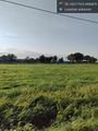
The wet, grassy field underlying the geohash.
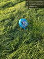
Perhaps some airborne geohasher reached the spot prior to me?
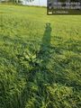
Beardygrade at the right spot.
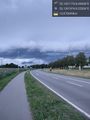
Some serious wheather looming ahead.


Achievements
Beardygrade earned the Land geohash achievement
|