Difference between revisions of "2024-08-25 65 30"
| (5 intermediate revisions by 2 users not shown) | |||
| Line 9: | Line 9: | ||
== Expedition == | == Expedition == | ||
| − | + | Finally, an accessible point for me in this difficult graticule! There is only a 1.9% probability that a random point in it hits a part of Finland that is not border zone, which means that there are on average about seven accessible hashpoints per year. Only three of them are expected to be on days when I could realistically have an expedition without skipping work (Friday to Sunday), and half of the time it is snowy season when access to terrain is difficult but getting to lakes may be easier. Therefore, I can expect about two doable hashpoints per year, and this happened to be a lucky day since it was a summer Sunday. | |
| − | + | After I noticed this hashpoint on Friday, Fiancée and I had a discussion and decided to do an ex tempore visit to her parents in Kuusamo. We drove there on Saturday, and I went adventuring on Sunday forenoon after breakfast. Getting to the hashpoint would require driving about 60 kilometers and walking a few kilometres. There was a road that went much closer than that, but it would likely be a private road with access forbidden for outsiders. | |
| + | |||
| + | I drove from Kuusamo to Lämsänkylä and Tammela. | ||
| + | It turned out that the last road (Suurijärventie) was indeed off limits, | ||
| + | so I had to find a place by Tammelantie road where I could leave the car. | ||
| + | There were many small paths and tracks branching off the road, | ||
| + | but all of them led to houses, some obviously abandoned, | ||
| + | but I still did not want to block the driveways. | ||
| + | I eventually found a track that was not drawn in the map and led to only forest, | ||
| + | so I chose to reverse and park there. | ||
| + | I then walked about 2.3 kilometres, | ||
| + | first on the roads, then in the forest, | ||
| + | until I reached the hashpoint with little difficulty. | ||
| + | The terrain was quite varied, | ||
| + | being hilly and swampy in places, | ||
| + | but overall fairly easy to traverse. | ||
| + | There were plenty of ripe berries in the forest, and I ate a lot of them as I went. | ||
| − | + | I followed pretty much the same route back to the car and drove back to Kuusamo. | |
| + | Out of curiosity, I made a short detour to the currently closed border crossing point | ||
| + | just to see how it looked like. | ||
| + | I could not go beyond the parking area, and there was not really anything to see there, so I turned back soon. | ||
| + | During the drive back to Kuusamo it started to rain fairly heavily, and I was very glad to have avoided getting wet. | ||
| + | I believed it would only rain in the evening (and it did), | ||
| + | though I should already know better than to have too much faith in weather forecasts. | ||
| + | According to the GPS receiver, the length of the trip was about 130 kilometres, | ||
| + | of which I walked 4.6 kilometres. | ||
| + | We drove back to Oulu later in the evening. | ||
== Tracklog == | == Tracklog == | ||
| − | < | + | <span style="color:#0000ff">Blue = driving</span>, |
| + | <span style="color:#ff0000">red = walking</span>. | ||
| + | |||
| + | {{tracklog|2024-08-25 65 30 tracklog.gpx}} | ||
== Photos == | == Photos == | ||
| − | |||
| − | |||
| − | |||
<gallery perrow="15"> | <gallery perrow="15"> | ||
| − | Image:2024-08-25_65_30_01-car1.jpg | I could not continue this way with the car. | + | Image:2024-08-25_65_30_01-car1.jpg | I could not continue this way with the car, so I had to park somewhere else and start walking. |
| − | Image:2024-08-25_65_30_02-gate.jpg | The gate and the traffic sign. “Vehicles prohibited; Private road; Driving allowed with permission from the road cooperative” | + | Image:2024-08-25_65_30_02-gate.jpg | The gate and the traffic sign. “Vehicles prohibited; Private road; Driving allowed with permission from the road cooperative.” |
Image:2024-08-25_65_30_03-car2.jpg | Where I parked the car and continued on foot. | Image:2024-08-25_65_30_03-car2.jpg | Where I parked the car and continued on foot. | ||
Image:2024-08-25_65_30_04-mushroom.jpg | Fly agaric (''Amanita muscaria''), a common poisonous mushroom, with nearly ripe lingonberries (''Vaccinium vitis-idaea''). | Image:2024-08-25_65_30_04-mushroom.jpg | Fly agaric (''Amanita muscaria''), a common poisonous mushroom, with nearly ripe lingonberries (''Vaccinium vitis-idaea''). | ||
| Line 32: | Line 57: | ||
Image:2024-08-25_65_30_08-lake.jpg | View to lake Peurajärvi. | Image:2024-08-25_65_30_08-lake.jpg | View to lake Peurajärvi. | ||
Image:2024-08-25_65_30_09-clearing1.jpg | A mossy clearing in the forest. | Image:2024-08-25_65_30_09-clearing1.jpg | A mossy clearing in the forest. | ||
| − | Image:2024-08-25_65_30_10-selfie.jpg | Selfie at the hashpoint. My tongue | + | Image:2024-08-25_65_30_10-selfie.jpg | Selfie at the hashpoint. My tongue was purple from the bilberries that I had eaten. |
Image:2024-08-25_65_30_11-gpsr1.jpg | Proof of location. | Image:2024-08-25_65_30_11-gpsr1.jpg | Proof of location. | ||
Image:2024-08-25_65_30_12-gpsr2.jpg | Proof of date and time. | Image:2024-08-25_65_30_12-gpsr2.jpg | Proof of date and time. | ||
| − | Image:2024-08-25_65_30_13-clearing2.jpg | Another beautiful clearing. | + | Image:2024-08-25_65_30_13-clearing2.jpg | Another beautiful little clearing. |
| − | Image:2024-08-25_65_30_14-deerked.jpg | A deer ked (''Lipoptena cervi'') that ended up on my skin. | + | Image:2024-08-25_65_30_14-deerked.jpg | A deer ked (''Lipoptena cervi'') that ended up on my skin. These are more common in southern Finland. |
| − | Image:2024-08-25_65_30_15-road.jpg | A nice view from | + | Image:2024-08-25_65_30_15-road.jpg | A nice view from Tammelantie road. |
</gallery> | </gallery> | ||
== Achievements == | == Achievements == | ||
| − | {{Land geohash | name = Kripakko | latitude = 65 | longitude = 30 | date = 2024-08-25}} | + | {{Land geohash | name = [[User:Kripakko|Kripakko]] | latitude = 65 | longitude = 30 | date = 2024-08-25}} |
| − | {{Graticule unlocked | name = Kripakko | latitude = 65 | longitude = 30 | date = 2024-08-25}} | + | {{Graticule unlocked | name = [[User:Kripakko|Kripakko]] | latitude = 65 | longitude = 30 | date = 2024-08-25}} |
| + | {{Hunter gatherer achievement | name = [[User:Kripakko|Kripakko]] | latitude = 65 | longitude = 30 | date = 2024-08-25 | food = bilberries and crowberries | ||
| + | }} | ||
__NOTOC__ | __NOTOC__ | ||
| − | |||
| − | |||
| − | |||
| − | |||
| − | |||
| − | |||
| − | |||
| − | |||
| − | |||
[[Category:Expeditions]] | [[Category:Expeditions]] | ||
| − | |||
[[Category:Expeditions with photos]] | [[Category:Expeditions with photos]] | ||
| − | |||
| − | |||
| − | |||
| − | |||
[[Category:Coordinates reached]] | [[Category:Coordinates reached]] | ||
| − | + | {{location|FI|14}} | |
| − | |||
| − | |||
| − | |||
| − | |||
| − | |||
| − | |||
| − | |||
| − | |||
| − | |||
| − | |||
| − | |||
| − | |||
| − | |||
Latest revision as of 07:56, 31 August 2024
| Sun 25 Aug 2024 in 65,30: 65.7538654, 30.0136727 geohashing.info google osm bing/os kml crox |
Location
In a forest near lake Peurajärvi, Kuusamo.
The point on a topographic map: [1]
Participants
Expedition
Finally, an accessible point for me in this difficult graticule! There is only a 1.9% probability that a random point in it hits a part of Finland that is not border zone, which means that there are on average about seven accessible hashpoints per year. Only three of them are expected to be on days when I could realistically have an expedition without skipping work (Friday to Sunday), and half of the time it is snowy season when access to terrain is difficult but getting to lakes may be easier. Therefore, I can expect about two doable hashpoints per year, and this happened to be a lucky day since it was a summer Sunday.
After I noticed this hashpoint on Friday, Fiancée and I had a discussion and decided to do an ex tempore visit to her parents in Kuusamo. We drove there on Saturday, and I went adventuring on Sunday forenoon after breakfast. Getting to the hashpoint would require driving about 60 kilometers and walking a few kilometres. There was a road that went much closer than that, but it would likely be a private road with access forbidden for outsiders.
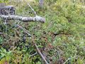
I drove from Kuusamo to Lämsänkylä and Tammela. It turned out that the last road (Suurijärventie) was indeed off limits, so I had to find a place by Tammelantie road where I could leave the car. There were many small paths and tracks branching off the road, but all of them led to houses, some obviously abandoned, but I still did not want to block the driveways. I eventually found a track that was not drawn in the map and led to only forest, so I chose to reverse and park there. I then walked about 2.3 kilometres, first on the roads, then in the forest, until I reached the hashpoint with little difficulty. The terrain was quite varied, being hilly and swampy in places, but overall fairly easy to traverse. There were plenty of ripe berries in the forest, and I ate a lot of them as I went.
I followed pretty much the same route back to the car and drove back to Kuusamo. Out of curiosity, I made a short detour to the currently closed border crossing point just to see how it looked like. I could not go beyond the parking area, and there was not really anything to see there, so I turned back soon. During the drive back to Kuusamo it started to rain fairly heavily, and I was very glad to have avoided getting wet. I believed it would only rain in the evening (and it did), though I should already know better than to have too much faith in weather forecasts. According to the GPS receiver, the length of the trip was about 130 kilometres, of which I walked 4.6 kilometres. We drove back to Oulu later in the evening.
Tracklog
Blue = driving, red = walking.
Photos
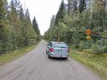
I could not continue this way with the car, so I had to park somewhere else and start walking.
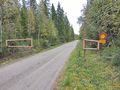
The gate and the traffic sign. “Vehicles prohibited; Private road; Driving allowed with permission from the road cooperative.”
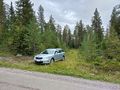
Where I parked the car and continued on foot.
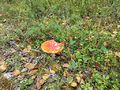
Fly agaric (Amanita muscaria), a common poisonous mushroom, with nearly ripe lingonberries (Vaccinium vitis-idaea).
Someone's driveway with a funny American “Bear crossing” sign. I did not see any bears anywhere.
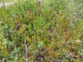
Ripe and delicious bilberries (Vaccinium myrtillus).
Nice and juicy crowberries (Empetrum nigrum).
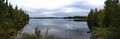
View to lake Peurajärvi.
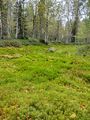
A mossy clearing in the forest.
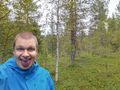
Selfie at the hashpoint. My tongue was purple from the bilberries that I had eaten.
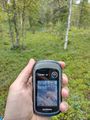
Proof of location.
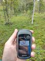
Proof of date and time.
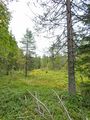
Another beautiful little clearing.
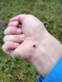
A deer ked (Lipoptena cervi) that ended up on my skin. These are more common in southern Finland.
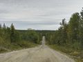
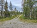
A nice view from Tammelantie road.


Achievements
Kripakko earned the Land geohash achievement
|
Kripakko earned the Graticule Unlocked Achievement
|
Kripakko earned the Hunter gatherer achievement
|