Difference between revisions of "2024-08-23 51 4"
MyrtleGlacy (talk | contribs) |
(Categories) |
||
| (One intermediate revision by one other user not shown) | |||
| Line 10: | Line 10: | ||
===MyrtleGlacy=== | ===MyrtleGlacy=== | ||
| − | + | We grabbed a train early in the morning so we could combine this expedition with a walk in the forest here. We’d never been to Bergen op Zoom so it was great to discover a new place like this. | |
| + | |||
| + | After having reached Bergen op Zoom, we immediately went east towards the hash, away from the city center. We walked through a residential area but before we left the city, we had to find a bathroom. A slight detour was made towards a couple of shops where we could make our pit-stop at the Salvation Army. Well, not the Salvation Army apparently because we went in the wrong door and instead walked in at an organization called [https://vivboz.nl/ Vrouwen Integratie Vandaag] (Women integrate today) an organization aimed at helping women who are new to the Netherlands and have trouble with integration do so. They were very friendly, and it sounded like a great cause. | ||
| + | |||
| + | Continuing our path, we decided to follow our originally planned route backwards, which I suppose doesn’t make much of a difference. The edge of the forest was crowded with small restaurants, an climbing forest and a hostel amongst other things. We found our path into the actual forest and found started navigating. It was still kind of early in the day, so there were not a lot of other people around. | ||
| + | |||
| + | The most interesting part about this expedition was a part of this forest called [https://landgoedzoomland.yolasite.com/de-zeezuiper.php the Zeezuiper]. It is a swampy area that is seemingly the reason for the town name of Bergen op Zoom. This type of swamp used to be called a Sooma (watery area) and I hope that the leap from Sooma to Zoom doesn’t sound too far-fetched. It wasn’t as watery as we thought it would be, but we (of course) did not enter the area as it had been very well fenced off, so maybe it was worse than it looked. We first saw it from the south and the east, but from the north and the west, the water was way more obvious. | ||
| + | |||
| + | Just past the Zeezuiper, I went about 60 meters off-path into the forest to grab the hash. There were a lot of ferns, thorny plants and rotting tree logs, but the hash was still easy to reach. I’m amazing that I found no ticks on my body afterwards. | ||
| + | |||
| + | After the hash, we continued our walk, deciding to loop back to the restaurants at the edge of the forest to grab some lunch. We then walked back to the train station, briefly shopping in Bergen op Zoom, but we didn’t see much of the city sadly. | ||
| + | |||
| + | All in all an expedition in an area where I have never been. Pretty cool :) | ||
| + | |||
== Photos == | == Photos == | ||
| Line 19: | Line 32: | ||
2024-08-23_51_4_Selfie.jpeg|Nice selfie right? | 2024-08-23_51_4_Selfie.jpeg|Nice selfie right? | ||
</gallery> | </gallery> | ||
| − | |||
__NOTOC__ | __NOTOC__ | ||
| − | [[Category: | + | [[Category:Expeditions]] |
| + | [[Category:Coordinates reached]] | ||
{{location|NL|NB}} | {{location|NL|NB}} | ||
Latest revision as of 08:04, 26 August 2024
| Fri 23 Aug 2024 in 51,4: 51.4988125, 4.3351287 geohashing.info google osm bing/os kml crox |
Location
In a forest east of Bergen op Zoom
Participants
- MyrtleGlacy
- MyrtleGlacy's Girlfriend
Plans
MyrtleGlacy
We grabbed a train early in the morning so we could combine this expedition with a walk in the forest here. We’d never been to Bergen op Zoom so it was great to discover a new place like this.
After having reached Bergen op Zoom, we immediately went east towards the hash, away from the city center. We walked through a residential area but before we left the city, we had to find a bathroom. A slight detour was made towards a couple of shops where we could make our pit-stop at the Salvation Army. Well, not the Salvation Army apparently because we went in the wrong door and instead walked in at an organization called Vrouwen Integratie Vandaag (Women integrate today) an organization aimed at helping women who are new to the Netherlands and have trouble with integration do so. They were very friendly, and it sounded like a great cause.
Continuing our path, we decided to follow our originally planned route backwards, which I suppose doesn’t make much of a difference. The edge of the forest was crowded with small restaurants, an climbing forest and a hostel amongst other things. We found our path into the actual forest and found started navigating. It was still kind of early in the day, so there were not a lot of other people around.
The most interesting part about this expedition was a part of this forest called the Zeezuiper. It is a swampy area that is seemingly the reason for the town name of Bergen op Zoom. This type of swamp used to be called a Sooma (watery area) and I hope that the leap from Sooma to Zoom doesn’t sound too far-fetched. It wasn’t as watery as we thought it would be, but we (of course) did not enter the area as it had been very well fenced off, so maybe it was worse than it looked. We first saw it from the south and the east, but from the north and the west, the water was way more obvious.
Just past the Zeezuiper, I went about 60 meters off-path into the forest to grab the hash. There were a lot of ferns, thorny plants and rotting tree logs, but the hash was still easy to reach. I’m amazing that I found no ticks on my body afterwards.
After the hash, we continued our walk, deciding to loop back to the restaurants at the edge of the forest to grab some lunch. We then walked back to the train station, briefly shopping in Bergen op Zoom, but we didn’t see much of the city sadly.
All in all an expedition in an area where I have never been. Pretty cool :)
Photos
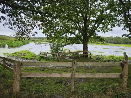
A very pretty swamp
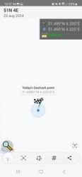
Expedition successful!
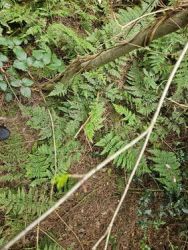
Not much to say. A lot of forest in this forest
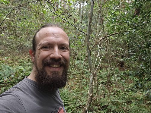
Nice selfie right?


