Difference between revisions of "2024-10-02 47 -122"
(An expedition message sent via Geohash Droid for Android.) |
m |
||
| (5 intermediate revisions by the same user not shown) | |||
| Line 1: | Line 1: | ||
| − | + | {{meetup graticule|date=2024-10-02|lat=47|lon=-122| graticule_name=Seattle | |
| − | + | | graticule_link=Seattle, Washington }} | |
| − | |||
| − | |||
| − | |||
| − | |||
| − | |||
| − | |||
| − | |||
== Location == | == Location == | ||
| − | + | On a side road in east Redmond WA | |
== Participants == | == Participants == | ||
| − | + | * [[User:Thomcat|Thomcat]] | |
| − | |||
== Plans == | == Plans == | ||
| − | + | Drive by on the way back to the office from a doctor's appointment | |
== Expedition == | == Expedition == | ||
| − | + | Appointment went well, headed north on 405 and almost forgot to hang a right to Redmond. Cut east on 85th and almost didn't need the GPS to get me to the neighborhood, and a certain famous [https://kingcountylocalblog.com/2024/04/08/unique-roads-of-king-county-196th-avenue-ne-red-brick-road brick road]. | |
| + | |||
| + | Here is some more information about the greater [https://www.craigmagnuson.com/yellowstone.htm Yellowstone Trail], including a black and white photo of the area around the geohashpoint. If I had been around then, I could have walked right to the point, but in our modern implementation, it was behind a fence, complete with barbed wire and no trespassing sign. | ||
| + | |||
| + | An interesting expedition, not far out of my way, but no success this time. I celebrated by getting a much-needed car wash nearby! | ||
== Tracklog == | == Tracklog == | ||
| Line 29: | Line 25: | ||
--> | --> | ||
<gallery perrow="5"> | <gallery perrow="5"> | ||
| + | |||
| + | Image:2024-10-02_47_-122_thomcat_1727888769440.jpg|red brick highway [https://openstreetmap.org/?mlat=47.65806500&mlon=-122.07881600&zoom=16 @47.6581,-122.0788] | ||
| + | |||
| + | Image:2024-10-02_47_-122_thomcat_1727888850008.jpg|geohasher [https://openstreetmap.org/?mlat=47.65803100&mlon=-122.07875300&zoom=16 @47.6580,-122.0788] | ||
| + | |||
| + | Image:2024-10-02_47_-122_thomcat_1727888938613.jpg|sign of the times [https://openstreetmap.org/?mlat=47.65863097&mlon=-122.07832397&zoom=16 @47.6586,-122.0783] | ||
| + | |||
| + | Image:2024-10-02_47_-122_thomcat_1727889777675.jpg|need car wash [https://openstreetmap.org/?mlat=47.67673400&mlon=-122.10647197&zoom=16 @47.6767,-122.1065] | ||
</gallery> | </gallery> | ||
| Line 36: | Line 40: | ||
__NOTOC__ | __NOTOC__ | ||
| − | |||
| − | |||
| − | |||
| − | |||
| − | |||
| − | |||
| − | |||
| − | |||
| − | |||
| − | |||
[[Category:Expeditions]] | [[Category:Expeditions]] | ||
| − | |||
[[Category:Expeditions with photos]] | [[Category:Expeditions with photos]] | ||
| − | |||
| − | |||
| − | |||
| − | |||
| − | |||
| − | |||
| − | |||
[[Category:Coordinates not reached]] | [[Category:Coordinates not reached]] | ||
| − | |||
| − | |||
| − | |||
| − | |||
| − | |||
[[Category:Not reached - No public access]] | [[Category:Not reached - No public access]] | ||
| − | + | {{location|US|WA|KN}} | |
| − | |||
| − | |||
| − | |||
| − | |||
Latest revision as of 22:31, 2 October 2024
| Wed 2 Oct 2024 in Seattle: 47.6580562, -122.0785881 geohashing.info google osm bing/os kml crox |
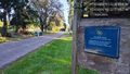
Location
On a side road in east Redmond WA
Participants
Plans
Drive by on the way back to the office from a doctor's appointment
Expedition
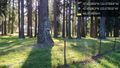
Appointment went well, headed north on 405 and almost forgot to hang a right to Redmond. Cut east on 85th and almost didn't need the GPS to get me to the neighborhood, and a certain famous brick road.
Here is some more information about the greater Yellowstone Trail, including a black and white photo of the area around the geohashpoint. If I had been around then, I could have walked right to the point, but in our modern implementation, it was behind a fence, complete with barbed wire and no trespassing sign.
An interesting expedition, not far out of my way, but no success this time. I celebrated by getting a much-needed car wash nearby!
Tracklog
Photos
red brick highway @47.6581,-122.0788

geohasher @47.6580,-122.0788
sign of the times @47.6586,-122.0783
need car wash @47.6767,-122.1065


