Difference between revisions of "2024-10-17 48 11"
From Geohashing
| Line 31: | Line 31: | ||
{{land geohash | latitude = 48 | longitude = 11 | date = 2024-10-17 | name = [[User:Iqui|Iqui]] | image = 2024-10-17 48 11 location.jpeg }} | {{land geohash | latitude = 48 | longitude = 11 | date = 2024-10-17 | name = [[User:Iqui|Iqui]] | image = 2024-10-17 48 11 location.jpeg }} | ||
{{Bicycle geohash | latitude = 48 | longitude = 11 | date = 2024-10-17 | name = [[User:Iqui|Iqui]] | distance = 57,2 km | bothways = true | image = 2024-10-17 48 11 view of location.jpeg }} | {{Bicycle geohash | latitude = 48 | longitude = 11 | date = 2024-10-17 | name = [[User:Iqui|Iqui]] | distance = 57,2 km | bothways = true | image = 2024-10-17 48 11 view of location.jpeg }} | ||
| − | |||
| − | |||
__NOTOC__ | __NOTOC__ | ||
Latest revision as of 20:16, 18 October 2024
| Thu 17 Oct 2024 in 48,11: 48.4794262, 11.6197414 geohashing.info google osm bing/os kml crox |
Location
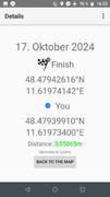
In a field in Schweitenkirchen
Participants
Expedition
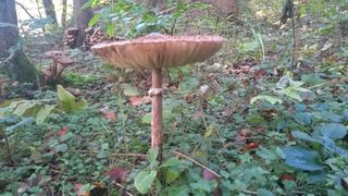
- Iqui: The hash was more accessible than it looks on the photos, because there was a small path leading almost directly to the location. The bike ride was amazing, as the weather felt more like summer than fall, and the coloured leaves were a nice touch.
Photos
Tracklog
Achievements
Iqui earned the Land geohash achievement
|
Iqui earned the Bicycle geohash achievement
|


