Difference between revisions of "2024-10-14 50 8"
(Test) |
m (Replacing ribbon with template) |
||
| (4 intermediate revisions by one other user not shown) | |||
| Line 1: | Line 1: | ||
| − | |||
| − | |||
| − | |||
{{meetup graticule | {{meetup graticule | ||
| lat=50 | | lat=50 | ||
| Line 8: | Line 5: | ||
}} | }} | ||
== Location == | == Location == | ||
| − | On a river called ''Hengstenbach'' surrounded by trees, at the eastern town limit of Dreieichenhain (suburb of Dreieich), in Offenbach district, Hesse, Germany. | + | On a <s>stream</s> <strong>river</strong> called ''Hengstenbach'' surrounded by trees, at the eastern town limit of Dreieichenhain (suburb of Dreieich), in Offenbach district, Hesse, Germany. |
This day’s weather: overcast with a hint of sunshine – it started raining between 16:00 and 17:00 (<abbr title="Central European Summer Time">CEST</abbr>). | This day’s weather: overcast with a hint of sunshine – it started raining between 16:00 and 17:00 (<abbr title="Central European Summer Time">CEST</abbr>). | ||
| Line 149: | Line 146: | ||
| waterhazard = river that was incorrectly mapped as a (passable) <code>waterway=[https://wiki.openstreetmap.org/wiki/Tag:waterway=stream stream]</code> in OpenStreetMap | | waterhazard = river that was incorrectly mapped as a (passable) <code>waterway=[https://wiki.openstreetmap.org/wiki/Tag:waterway=stream stream]</code> in OpenStreetMap | ||
}} | }} | ||
| − | {{ | + | {{Sightseeing achievement |
| − | | | + | | latitude = 50 |
| − | | | + | | longitude = 8 |
| − | | | + | | date = 2024-10-14 |
| − | | | + | | wikipage = de:Burg Hayn |
| − | + | | name = [[User:Green guy!|Green guy!]] | |
}} | }} | ||
Latest revision as of 19:40, 12 November 2024
| Mon 14 Oct 2024 in 50,8: 50.0036423, 8.7160791 geohashing.info google osm bing/os kml crox |
Location
On a stream river called Hengstenbach surrounded by trees, at the eastern town limit of Dreieichenhain (suburb of Dreieich), in Offenbach district, Hesse, Germany.
This day’s weather: overcast with a hint of sunshine – it started raining between 16:00 and 17:00 (CEST).
Participants
- Green guy! (talk)
- Green guy!’s mother
- Green guy!’s father
- GeorgDerReisende
Plans
Green guy!
Due to this day being a Monday, unfortunately, many delightful restaurants are closed, leaving just a single option!
- Drive towards Dreieichenhain and have lunch at the restaurant of the sports center Turnverein 1880 Dreieichenhain (it closes at 14:00)
- Drive into Dreieichenhain and park next to the castle Burg Hayn in der Dreieich
- Go on a walk to visit the hashpoint
- note for GeorgDerReisende: An earlier time is not possible for us, mainly due to restaurant planning and my mother having an appointment in the forenoon.
- Walk around the castle
- Drive back home
GeorgDerReisende
For me it seems that the stream flows some meters north of the hash, but it looks all as private and closed area. But I will try it. I leave Kassel at 8:23, and will arrive at the bus stop Burg Hayn at 11:55. From there are some meters to the hash area. Look out for a man in yellow and black!
Expedition
Green guy!
A nice expedition, but we couldn’t reach the coordinates – a combination of a bit No Trespassing (many barriers) with mainly My Kingdom for a Boat (as the supposed stream turned out to be a river of several meters in width) made this unfeasible.
The way there
First of all, my father and I picked up my mother from her appointment. From there, we drove to Dreieichenhain with the intention of eating since it was already noon.
Having lunch at the restaurant
Upon arriving at the sports center Turnverein 1880 Dreieichenhain, my mother was concerned at first about the restaurant being closed as the shutters were down on some windows, but it was open. The eatery turned out to be a lot more noble than I expected (I was thinking of something more akin to a canteen or bistro, forgetting about another sports center that is located close to our home and also has a high-quality restaurant). However, there was a slight smell of smoke transpiring from the walls, which is actually a residue from 20+ years ago when smoking indoors was still allowed. We solved this issue by nestling in a semi-separated area not affected by the smell. In this place, I ate a tasty Viennese schnitzel (pork meat) with french fries and a side salad.

Reaching the coordinates
After lunch, we tried visiting the hashpoint: We parked our car on the public parking lot next to Burg Hayn and walked towards the hashpoint.
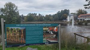
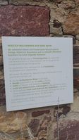
Looking at the Burgweiher and a sign informing about its guardrails
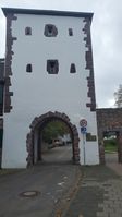
Entrance to Dreieichenhain’s historic center
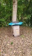
“A beautiful place knows no waste.”
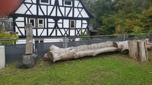
“Babble bench”, a place to sit down and talk in Hessian
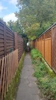
Under the trees


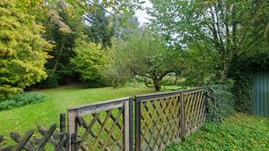
At the closest possible point to the coordinates, we couldn’t continue due to fences, gates and signs denoting private property (no trespassing).
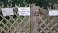
“Entering the private property is only allowed with explicit consent of the owner”, better known as No Trespassing
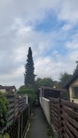
A tall conifer sticking out of the residential scape
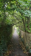
Roof of leaves


As we reached a bridge that crosses over the supposed “stream” the hashpoint lies on (Hengstenbach translates to “Stallion’s Stream” after all, plus OpenStreetMap had it mapped as stream), it turned out to be a river of several meters in width with a considerable current and steep banks, earning me the My Kingdom for a Boat achievement.
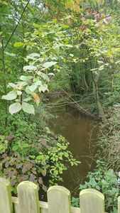
The Hengstenbach, looking away from the hashpoint (against the flow direction)
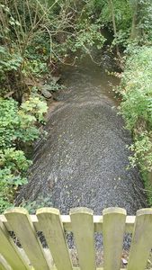
Looking towards the coordinates – you definitely can’t easily reach the hashpoint!


Despite not reaching the coordinates, we had a relaxing time walking around the area. On our way back, at one point, we walked on a street called Am Gebück. My mother misread that street’s sign as “Im Gebäck” (translation: “In the Pastries”), causing us to have a short laugh.
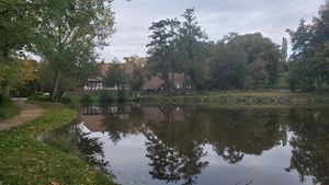
Lulls turn lakes into lovely mirrors.
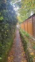
Another place of no access
Im Gebäck? Am Gebäck? No, the sign reads Am Gebück!


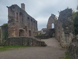
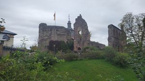
Visiting Burg Hayn
After not reaching the coordinates, we walked around and inside the yard of Burg Hayn, a castle remnant from the Middle Ages. On the historical premises, a few youngsters (in the transitioning age from children to teenagers) were eagerly playing tag with each other, zanily squeaking while frantically running about. One interesting sight (and read), found in the remnants of the castle’s residential quarters, was a big stone block with almost a thousand years old (!) Latin text chiseled into it.
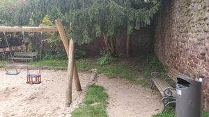
Dark corner of the playground
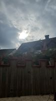
Sunny, not rainy!
Without a license, you’re not allowed to take commercial photos on the castle site. Fortunately, this wiki is non-commercial as far as I know.
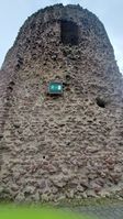
The donjon of Burg Hayn
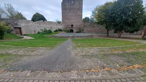
The open-air theater
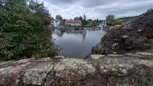
Beautiful look at the Burgweiher from inside the castle walls
The castle’s residential quarters – my attempt at replicating the photo from German Wikipedia’s Burg Hayn article
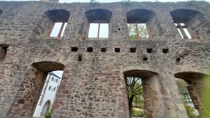
Windows, but not made by Microsoft
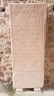
Potesne legere Latine?
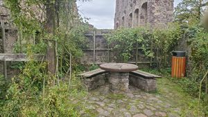
The rosarium
Site plan of Burg Hayn
One final, beautiful look at the castle site


The way back home
Finally, we drove home. While driving on a rural road, my father decided to steer a bit to the right so the tires would start rubbing against the road’s edge marking, causing a droning sound. He asked me to determine the musical pitches of the droning using my absolute hearing. (I determined piano notes from F4 to A4 – faster driving meant higher tone frequency.) We all had a really good laugh from the tires’ tunes and my determination of tones!
Final verdict
During all of the expedition, the weather was way better than expected, with the sun shining through the cloud cover at one moment! Let’s be honest: I had worried waaay too much about rain!
Also, my parents were delighted about the fact that they would have never seen these castle remnants of Burg Hayn if it hadn’t been for the geohash coordinates!
GeorgDerReisende
Arrived in time, walked to the entrance of the hash area, found a gate, walked around the whole area, looked again to the gate, walked around the village, didn't see a group of three. A stopover of one hour.
Tracklog
Green guy!: Walking to the hashpoint, then visiting Burg Hayn
- Direction: starting in the southeast, going north towards the hashpoint, then northwest, finally going towards the castle and back southeast
- GPS accuracy: medium (lower accuracy near building and castle walls)
- Markers show all locations where I took photos – many of them are taken for OpenStreetMap surveying and not uploaded here.
GeorgDerReisende
Pictures
GeorgDerReisende

the gate

.jpg)
Achievements
Green guy!
First-time
I earned these for the first time from this geohash.
Green guy! earned the My kingdom for a boat consolation prize
|
Green guy! earned the Sightseeing achievement
|
Recurring
I already earned these from an earlier geohash, but fulfilled the conditions again on this one.
Green guy! earned the No trespassing consolation prize
|
I’m not sure if this actually counts as No Trespassing since the river itself would have likely prevented us from reaching the hashpoint even without the presence of barriers and signs.