Difference between revisions of "2008-09-20 34 -117"
imported>SouthLAMike |
imported>FippeBot m (Location) |
||
| Line 27: | Line 27: | ||
[[Category:Expeditions with photos]] | [[Category:Expeditions with photos]] | ||
[[Category:Coordinates reached]] | [[Category:Coordinates reached]] | ||
| + | {{location|US|CA|LO}} | ||
Latest revision as of 07:01, 7 August 2019
| Sat 20 Sep 2008 in 34,-117: 34.5939233, -117.8365649 geohashing.info google osm bing/os kml crox |
This geohash was in a residential neighborhood in the desert town of Lake Los Angeles. It was easy to reach, since it was at the intersection of 164th and Jubilee Trail. Mike got there about 4:30 and snapped a couple of pictures of the house where the has was located. I didn't actually go in the yard or knock on the door, so I guess I just got within 20 feet of the spot.
Lake Los Angeles is a classic desert town in the Antelope Valley, near Saddleback Butte.
I only waited at the location for a couple of minutes, because I was sure that no one else would show. Afterward, I headed back down Ave O toward the 14. I did come across a circling police helicopter. To the best that I could tell, it looked like boy had been hurt.
From there, I hit up a 7-11 and then went back over the pass into Los Angeles.
- Images of Lake Los Angeles
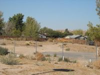
The location of the geohash.
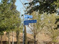
Street signs
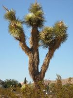
A Joshua tree near to the geohash location.

Mike looking wind-blown.


