Difference between revisions of "2008-11-03 32 -110"
imported>KarMann (add photos; add crazy conspiracy theories of government surveillance) |
imported>KarMann m (→Photos: watch note) |
||
| Line 24: | Line 24: | ||
<gallery> | <gallery> | ||
Image:2008-11-03 32 -110 1904-1024.jpg|GPS showing geohash, with map printout | Image:2008-11-03 32 -110 1904-1024.jpg|GPS showing geohash, with map printout | ||
| − | Image:2008-11-03 32 -110 1905-1024.jpg|GPS and my watch, with the date | + | Image:2008-11-03 32 -110 1905-1024.jpg|GPS and my watch, with the date (yes, I need to sync my watch more often) |
Image:2008-11-03 32 -110 1909-1024.jpg|View of the backyard containing the actual, proper geohash | Image:2008-11-03 32 -110 1909-1024.jpg|View of the backyard containing the actual, proper geohash | ||
Image:2008-11-03 32 -110 1911-1024.jpg|My ride back: The bus stop | Image:2008-11-03 32 -110 1911-1024.jpg|My ride back: The bus stop | ||
Revision as of 08:51, 4 November 2008
| Mon 3 Nov 2008 in 32,-110: 32.1967967, -110.9206633 geohashing.info google osm bing/os kml crox |
About
Monday's geohash was located in a walled-in backyard in a residential neighbourhood within Tucson itself. The alley behind the property was judged to be the closest accessible point.
After being dropped off in the vicinity, I made a short trip by foot through stravenue and alley to the geohash. I finished my cigarette and surveyed the rather unremarkable area, took a few pictures, and headed out for the bus stop. I only took the bus on the way out, so haven't got the Public Transport Geohash achievement yet.
People
One person showed up around 3:45 PM.
Achievements
KarMann earned the Consecutive geohash achievement
|
Conspiracy theories
On my way to the geohash, as I was getting close, I was buzzed by an U.S. Air Force C-130 Hercules, flying quite low, with suspicious-looking bulges near the tail. After the geohash, two F-16 Fighting Falcons came around. I suspect that the U.S. government is conducting surveillance of geohashing activities, using aerial reconnaissance and surveillance assets. Furthermore, at the geohash the night before, I was harassed by some kind of raptor (!!), likely an owl. It was probably carrying some ultra-miniaturized camera, possibly infrared or low-light gear, keeping tabs on any passing geohashers.
Photos
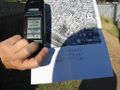
GPS showing geohash, with map printout
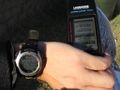
GPS and my watch, with the date (yes, I need to sync my watch more often)
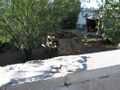
View of the backyard containing the actual, proper geohash
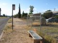
My ride back: The bus stop
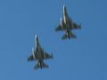
F-16 Falcons conducting surveillance
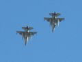
F-16 Falcons conducting surveillance
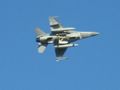
One of them makes another pass; note camera pods under wings.
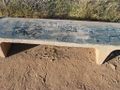
This bench looked likely to bear an xkcd marker, but came up empty.


