Difference between revisions of "2009-01-03 36 -77"
From Geohashing
imported>Ncbears |
imported>Ncbears (→Geological Features) |
||
| Line 14: | Line 14: | ||
==Geological Features== | ==Geological Features== | ||
| − | Rolling farmland (mostly corn and cotton). Geohash was located ~ | + | Rolling farmland (mostly corn and cotton). Geohash was located ~10 meters inside wooded area. About 375 meters from Lake Gaston, North Carolina and 4.0 miles/6.5 km south of the Virginia border. Open field between Geohash and road was used for corn crop. See Google Earth screenshot below. |
==Wildlife Encounters== | ==Wildlife Encounters== | ||
Revision as of 01:38, 4 January 2009
| Sat 3 Jan 2009 in 36,-77: 36.4861055, -77.9410178 geohashing.info google osm bing/os kml crox |
Contents
Report
Participants
Eisen & Bear - NCBears
Geological Features
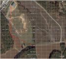
Rolling farmland (mostly corn and cotton). Geohash was located ~10 meters inside wooded area. About 375 meters from Lake Gaston, North Carolina and 4.0 miles/6.5 km south of the Virginia border. Open field between Geohash and road was used for corn crop. See Google Earth screenshot below.
Wildlife Encounters
- White-tail deer prints in field
- Eastern Gray squirrel along road
- Heard Red-Tailed hawk cry (always cool)
Weather
52°F/11°C, clear skies
Pictures

NCBears at N36 W77 Meetup near Lake Gaston, NC
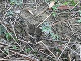
The deer beat us to the geohash again
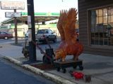
Geooink
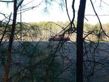
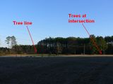
Geohash was just inside the treeline
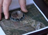
Orienting the map
How I triangulated using a map and compass
For the No Batteries Geohash Achievement


