Difference between revisions of "2009-01-03 36 -77"
imported>Ncbears (→Report) |
imported>Ncbears (→Report) |
||
| Line 6: | Line 6: | ||
}} | }} | ||
==Report== | ==Report== | ||
| − | We decided to conquer this virgin graticule because the N36 W77 geohash would take us to Lake Gaston, | + | We decided to conquer this virgin graticule because the N36 W77 geohash would take us to Lake Gaston, which is an area we seldom visit. There was freezing rain last night, but by the time we started our trek, the roads were drying off. We first went to our cabin to thank our kind-hearted and hard-working neighbors who repaired the washed-out road in the neighborhood. We did some target practice with our handguns then drove east to the geohash. |
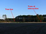
We navigated the old-fashioned...well, 20th Century way, using only the state road map. We drove an hour and arrived at the geohash parking area at about 1540. We were amazed that the area looked relatively unchanged from the Google Earth image. We guesstimated the geohash point using the map. We oriented the map and moved further back into the woods so we were aligned with the northern triangulation point - the bluish-green storage building (now two of them) almost directly north. Since the woods were thinned out and there was a lack of foliage, we could see the three triangulation points clearly. We then shifted south until we were aligned with the second triangulation point - the trees and the intersection just SSE of us. Since the tree line to the SE matched up, we knew we were right on the geohash point. | We navigated the old-fashioned...well, 20th Century way, using only the state road map. We drove an hour and arrived at the geohash parking area at about 1540. We were amazed that the area looked relatively unchanged from the Google Earth image. We guesstimated the geohash point using the map. We oriented the map and moved further back into the woods so we were aligned with the northern triangulation point - the bluish-green storage building (now two of them) almost directly north. Since the woods were thinned out and there was a lack of foliage, we could see the three triangulation points clearly. We then shifted south until we were aligned with the second triangulation point - the trees and the intersection just SSE of us. Since the tree line to the SE matched up, we knew we were right on the geohash point. | ||
Revision as of 02:10, 4 January 2009
| Sat 3 Jan 2009 in 36,-77: 36.4861055, -77.9410178 geohashing.info google osm bing/os kml crox |
Contents
Report
We decided to conquer this virgin graticule because the N36 W77 geohash would take us to Lake Gaston, which is an area we seldom visit. There was freezing rain last night, but by the time we started our trek, the roads were drying off. We first went to our cabin to thank our kind-hearted and hard-working neighbors who repaired the washed-out road in the neighborhood. We did some target practice with our handguns then drove east to the geohash.
We navigated the old-fashioned...well, 20th Century way, using only the state road map. We drove an hour and arrived at the geohash parking area at about 1540. We were amazed that the area looked relatively unchanged from the Google Earth image. We guesstimated the geohash point using the map. We oriented the map and moved further back into the woods so we were aligned with the northern triangulation point - the bluish-green storage building (now two of them) almost directly north. Since the woods were thinned out and there was a lack of foliage, we could see the three triangulation points clearly. We then shifted south until we were aligned with the second triangulation point - the trees and the intersection just SSE of us. Since the tree line to the SE matched up, we knew we were right on the geohash point.
We photographed our success and looked for signs of wildlife. After waiting 15 minutes for other XKCDers, we gathered up our hashing equipment and panda bear. We brought trash bags prepared to do some geotrash collection, but the area was spotless. A credit to the residents of Timber Lodge.
Participants
Eisen & Bear - NCBears
Geological Features
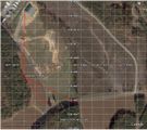
Rolling farmland (mostly corn and cotton). Geohash was located ~10 meters inside wooded area. About 375 meters from Lake Gaston and 4.0 miles/6.5 km south of the Virginia border. Open field between Geohash and road was used for corn crop. See Google Earth screenshot below.
Wildlife Encounters
- White-tail deer prints in field
- Eastern Gray squirrel along road
- Heard Red-Tailed hawk cry (always cool)
Weather
52°F/11°C, clear skies
Pictures

NCBears at N36 W77 Meetup near Lake Gaston, NC
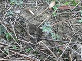
The deer beat us to the geohash again
Geooink
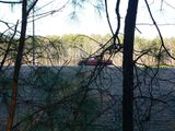
Geohash was just inside the treeline
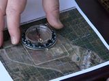
Orienting the map
How I triangulated using a map and compass
For the No Batteries Geohash Achievement


