Difference between revisions of "2009-02-15 41 -88"
imported>Shandd |
imported>Ekorren (Restoring destroyed content. Please create a new page when reporting a new expedition. New expedition content has been moved to 2010-03-19_41_-88.) |
||
| Line 1: | Line 1: | ||
{{meetup graticule | {{meetup graticule | ||
| − | | map=<map lat="41" lon="-88" date=" | + | | map=<map lat="41" lon="-88" date="2009-02-15" /> |
| lat=41 | | lat=41 | ||
| lon=-88 | | lon=-88 | ||
| − | | date= | + | | date=2009-02-15 |
| graticule_name=Aurora | | graticule_name=Aurora | ||
| graticule_link=Aurora, Illinois}} | | graticule_link=Aurora, Illinois}} | ||
== About == | == About == | ||
| − | + | Once again, it's February in rural Illinois. If you guessed "harvested corn field", you're correct! | |
| − | |||
== Expedition == | == Expedition == | ||
| − | [[User: | + | [[User:Excellentdude|excellentdude]]: [[2009-02-15 41 -89|...and now the conclusion]]. I was still on my way home from [[Kirksville, Missouri|northeast Missouri]] to [[Lansing, Michigan|mid-Michigan]]. Having just completed a [[2009-02-15 41 -89|hash]] in the [[Sterling, Illinois|graticule to the west]] and getting a photo or two of the very slight beginnings of sunset, the race was on to get to this potential hash before it was too dark to see and take pictures, not to mention get awesome pictures of the sunset. As I went, the sun went farther and farther down. Upon approaching the hash, it was clear that this one was even closer to I-80 than the previous one. I exited the interstate and went approximately two miles to the hash site. I was able to park at the base of a conveniently located relay tower. Once stopped, I quickly jumped out of my car and snapped a picture of the sunset from the base of the tower since it was beginning to fade. While there, I also took a picture of the tower for later reference to the distance to the hash. |
| − | + | I began to walk east down the road until I achieved the correct longitude. At that point, there was no fence and no houses relatively nearby, so I proceeded under the cover of slight darkness into the harvested corn field. The hash was quickly reached from there! When I arrived, I got the obligatory photos, another couple photos of the sunset for beauty and the tower for reference, and a shot of the nearest house. As I headed back to my car, I was able to get a couple photos to show just how close I-80 (my route home) was. If you look in the two photos below, you can see the headlights move along the interstate. | |
| − | + | The rest of the drive home was pleasant and uneventful. Yea road trip multihash! :-) | |
| − | |||
| − | |||
| − | |||
| − | |||
| − | |||
| − | |||
| − | |||
| − | |||
| − | |||
== Achievements == | == Achievements == | ||
| Line 31: | Line 21: | ||
| latitude = 41 | | latitude = 41 | ||
| longitude = -88 | | longitude = -88 | ||
| − | | date = | + | | date = 2009-02-15 |
| − | | name = | + | | name = excellentdude |
| + | }}{{Frozen Geohash | ||
| + | | latitude = 41 | ||
| + | | longitude = -88 | ||
| + | | date = 2009-02-15 | ||
| + | | name = excellentdude | ||
| + | }}{{Multihash | ||
| + | | latitude1 = 41 | ||
| + | | longitude1 = -89 | ||
| + | | latitude2 = 41 | ||
| + | | longitude2 = -88 | ||
| + | | date = 2009-02-15 | ||
| + | | name = excellentdude | ||
}} | }} | ||
| + | |||
| + | == Photos == | ||
| + | <gallery perrow="4"> | ||
| + | Image:2009-02-15 41 -88 First Sunset.jpg|Sunset upon arrival | ||
| + | Image:2009-02-15 41 -88 Tower For Reference.jpg|Tower below which I parked | ||
| + | Image:2009-02-15 41 -88 Clear Tower Sunset Portrait.jpg|Tower and sunset from hash | ||
| + | Image:2009-02-15 41 -88 Tower Sunset Landscape Alpha.jpg|Ditto | ||
| + | Image:2009-02-15 41 -88 The Hash.jpg|The hash itself | ||
| + | Image:2009-02-15 41 -88 Nearest House Portrait.jpg|Nearest house | ||
| + | Image:2009-02-15 41 -88 I-80 Alpha.jpg|I-80 | ||
| + | Image:2009-02-15 41 -88 I-80 Beta.jpg|Ditto | ||
| + | Image:2009-02-15 41 -88 GPS.png|I made it! | ||
| + | Image:2009-02-15 41 -88 Bad Hair Grin.jpg|Bad hair goofy grin | ||
| + | </gallery> | ||
[[Category:Expeditions]] | [[Category:Expeditions]] | ||
[[Category:Expeditions with photos]] | [[Category:Expeditions with photos]] | ||
[[Category:Coordinates reached]] | [[Category:Coordinates reached]] | ||
| + | [[Category:Meetup on 2009-02-15]] | ||
| + | [[Category:Meetup in 41 -88]] | ||
Revision as of 00:30, 20 March 2010
| Sun 15 Feb 2009 in Aurora: 41.3692524, -88.5834935 geohashing.info google osm bing/os kml crox |
Contents
About
Once again, it's February in rural Illinois. If you guessed "harvested corn field", you're correct!
Expedition
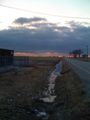
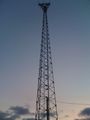
excellentdude: ...and now the conclusion. I was still on my way home from northeast Missouri to mid-Michigan. Having just completed a hash in the graticule to the west and getting a photo or two of the very slight beginnings of sunset, the race was on to get to this potential hash before it was too dark to see and take pictures, not to mention get awesome pictures of the sunset. As I went, the sun went farther and farther down. Upon approaching the hash, it was clear that this one was even closer to I-80 than the previous one. I exited the interstate and went approximately two miles to the hash site. I was able to park at the base of a conveniently located relay tower. Once stopped, I quickly jumped out of my car and snapped a picture of the sunset from the base of the tower since it was beginning to fade. While there, I also took a picture of the tower for later reference to the distance to the hash.
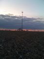
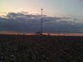
I began to walk east down the road until I achieved the correct longitude. At that point, there was no fence and no houses relatively nearby, so I proceeded under the cover of slight darkness into the harvested corn field. The hash was quickly reached from there! When I arrived, I got the obligatory photos, another couple photos of the sunset for beauty and the tower for reference, and a shot of the nearest house. As I headed back to my car, I was able to get a couple photos to show just how close I-80 (my route home) was. If you look in the two photos below, you can see the headlights move along the interstate.
The rest of the drive home was pleasant and uneventful. Yea road trip multihash! :-)
Achievements
excellentdude earned the Land geohash achievement
|
excellentdude earned the Frozen Geohash Achievement
|
excellentdude earned the Multihash Achievement
|
Photos
Sunset upon arrival
Tower below which I parked
Tower and sunset from hash
Ditto
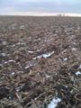
The hash itself
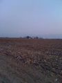
Nearest house
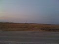
I-80
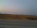
Ditto
I made it!

Bad hair goofy grin


