Difference between revisions of "2009-04-11 50 10"
imported>Manu m |
imported>Reinhard |
||
| Line 6: | Line 6: | ||
}} | }} | ||
| − | + | Due to the wonderful sunny weather on Holy Saturday [[user:Manu|Manu]] and Reinhard decided to go on a bike trip to the 2009-04-11 hash at 50,10 near Themar which would be about 20 km one way. Soon the trip got interesting, when a historical steam engine crossed our road and 2 km later bushes were burning beside the rails. Of course, a sequence of fire engines were about to come next. | |
| + | Arriving at the hash was less spectacular, getting as close as a few hundred meters to our destination we decided to leave the paved road and continue on a gravel path, which usually isn't too comfortable on the road bike I was riding. The last 60 metres we had to leave even this path and pushed our bikes uphill on a stubble field. | ||
| + | We've been there on time at 4 pm for the official meet-up, but noone else arrived, so we continued our way enjoying the ascent of [http://www.quaeldich.de/paesse/keulroder-berg/ Keulroder mountain] from where we coasted down on a idyllic road to Fischbach that hadn't yet been tracked for the [http://tourenplaner.quaeldich.de/?Aktion=GPS-Upload quaeldich.de GPS project] at that time. | ||
| + | After 42 km we were back home on this beautiful Saturday afternoon. | ||
| − | ---[[User: | + | ---[[User:Reinhard|Reinhard]] |
<gallery caption="Photo Gallery" widths="200px" heights="200px" perrow="2"> | <gallery caption="Photo Gallery" widths="200px" heights="200px" perrow="2"> | ||
Revision as of 17:53, 14 April 2009
| Sat 11 Apr 2009 in 50,10: 50.5143502, 10.6418935 geohashing.info google osm bing/os kml crox |
Due to the wonderful sunny weather on Holy Saturday Manu and Reinhard decided to go on a bike trip to the 2009-04-11 hash at 50,10 near Themar which would be about 20 km one way. Soon the trip got interesting, when a historical steam engine crossed our road and 2 km later bushes were burning beside the rails. Of course, a sequence of fire engines were about to come next.
Arriving at the hash was less spectacular, getting as close as a few hundred meters to our destination we decided to leave the paved road and continue on a gravel path, which usually isn't too comfortable on the road bike I was riding. The last 60 metres we had to leave even this path and pushed our bikes uphill on a stubble field.
We've been there on time at 4 pm for the official meet-up, but noone else arrived, so we continued our way enjoying the ascent of Keulroder mountain from where we coasted down on a idyllic road to Fischbach that hadn't yet been tracked for the quaeldich.de GPS project at that time.
After 42 km we were back home on this beautiful Saturday afternoon.
---Reinhard
- Photo Gallery
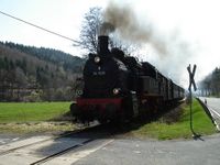
Steam engine we met on our way.
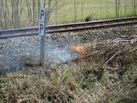
Fire at railroad embankment.
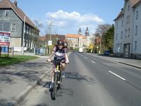
Manu cycling through Schleusingen.
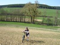
Reaching the geo hash.
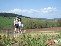
Manu and Reinhard at hash point.
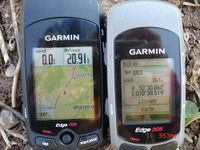
Proof of date and location (4 pm!).
XKCD.


