Difference between revisions of "2009-04-25 50 -118"
imported>Juventas (added some) |
imported>Juventas (drive and more pics, brain is now off) |
||
| Line 9: | Line 9: | ||
==Location== | ==Location== | ||
| − | Near the trailhead of Monashee Provincial Park | + | Near the trailhead of Monashee Provincial Park. |
==Participants== | ==Participants== | ||
| Line 23: | Line 23: | ||
==Expedition== | ==Expedition== | ||
===The Drive=== | ===The Drive=== | ||
| + | Highway 6 was a pleasure to drive as always. Sugar Lake Road was clear like I expected. I didn't see any vehicles in either direction until I got to the hydroelectric dam. There were military officers there, which was alarming, but they didn't indicate I should stop, so I continued through. | ||
| + | |||
| + | When I reached the turnoff for Monashee Provincial Park, my heart sank. It was covered in deep snow--not what I expected. I was surprised that one road was so well maintained, while the one for the park was not. | ||
| + | |||
| + | I had left earlier than usual, but it would not help when I was this far back. I decided to make the best of it. | ||
| + | |||
===The Hike=== | ===The Hike=== | ||
<gallery> | <gallery> | ||
image:2009-04-25_redcedar.jpg | image:2009-04-25_redcedar.jpg | ||
| + | image:2009-04-25_shuswap_river.jpg | ||
image:2009-04-25_snow_hole.jpg | image:2009-04-25_snow_hole.jpg | ||
| + | image:2009-04-25_feline_tracks.jpg | ||
image:2009-04-25_this_way.jpg | image:2009-04-25_this_way.jpg | ||
image:2009-04-25_rainbow_falls.jpg | image:2009-04-25_rainbow_falls.jpg | ||
</gallery> | </gallery> | ||
| + | |||
===Conclusions=== | ===Conclusions=== | ||
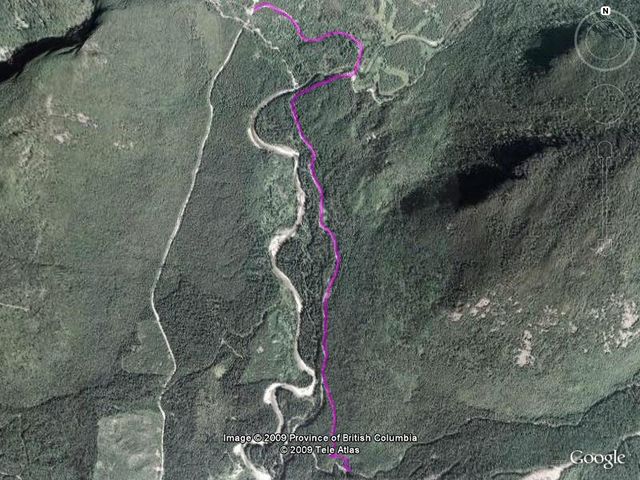
A 10.03km hike (round-trip) ending 6.61km from the coordinates. | A 10.03km hike (round-trip) ending 6.61km from the coordinates. | ||
| Line 37: | Line 46: | ||
==Lessons Learned== | ==Lessons Learned== | ||
| − | *Even popular areas have periods of inaccessibility | + | *Even popular areas have periods of relative inaccessibility. |
*As with forest service roads, park roads are not always maintained year-round. | *As with forest service roads, park roads are not always maintained year-round. | ||
*My boots need more wax. | *My boots need more wax. | ||
Revision as of 08:14, 28 April 2009
| Sat 25 Apr 2009 in Mabel Lake, British Columbia: 50.4809778, -118.3527699 geohashing.info google osm bing/os kml crox |
Contents
Location
Near the trailhead of Monashee Provincial Park.
Participants
Planning
The route I will need to drive is the same used to get to the primary trailhead of Monashee Provincial Park (a park with no road access). The elevation stays under 900m (should be under the current snow line) and should be well-maintained.
The road happens to end exactly at the base of mountain I will need to climb, a trek of two and half kilometers and a rise of 800m with no trail.
Expedition
The Drive
Highway 6 was a pleasure to drive as always. Sugar Lake Road was clear like I expected. I didn't see any vehicles in either direction until I got to the hydroelectric dam. There were military officers there, which was alarming, but they didn't indicate I should stop, so I continued through.
When I reached the turnoff for Monashee Provincial Park, my heart sank. It was covered in deep snow--not what I expected. I was surprised that one road was so well maintained, while the one for the park was not.
I had left earlier than usual, but it would not help when I was this far back. I decided to make the best of it.
The Hike
Conclusions
A 10.03km hike (round-trip) ending 6.61km from the coordinates.
Lessons Learned
- Even popular areas have periods of relative inaccessibility.
- As with forest service roads, park roads are not always maintained year-round.
- My boots need more wax.
Achievements
- Pushed myself a little harder.


