Difference between revisions of "2009-06-11 33 -84"
From Geohashing
imported>NWoodruff m (→Gallery) |
imported>NWoodruff (→Gallery) |
||
| Line 26: | Line 26: | ||
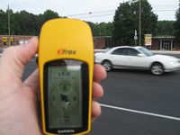
Image:2009061133-84NW01.JPG| 69 feet to go onto a major road. | Image:2009061133-84NW01.JPG| 69 feet to go onto a major road. | ||
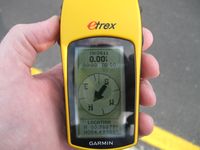
Image:2009061133-84NW02.JPG| 0.00 feet to go. The exact spot. | Image:2009061133-84NW02.JPG| 0.00 feet to go. The exact spot. | ||
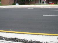
| − | Image:2009061133-84NW03.JPG| | + | Image:2009061133-84NW03.JPG| The actual Geohash spot. No marker here. There wasn't enough time between cars zooming past to leave anything. |
Image:2009061133-84NW04.JPG| | Image:2009061133-84NW04.JPG| | ||
</gallery> | </gallery> | ||
Revision as of 19:59, 12 June 2009
| Thu 11 Jun 2009 in Atlanta: 33.7887655, -84.4993303 geohashing.info google osm bing/os kml crox |
Graticule
About
Expedition
NWoodruff
The hash point ended up being right off the median in the center of the road. I reached it with 0.00 feet to go. Google maps has the hash point in the center of the south bound lane. I was worried that I would not be able to get to the actual hash point for the traffic in the 6pm rush hour. I did get a few cars and one large truck to honk at me as I was trying to get to 0.00 feet.
Gallery
- Photo Gallery
Achievements
NWoodruff earned the Land geohash achievement
|


